Bu fayl "Vikimedia Commons"dadır və digər layihələrdə istifadə edilə bilər.
təsvir səhifəsi
Faylın təsvir səhifəsinə get
Xülasə
İzahIron Curtain map.svg
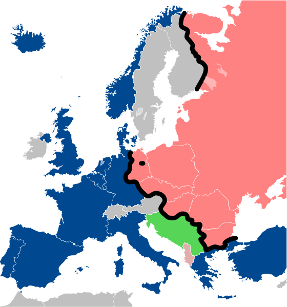
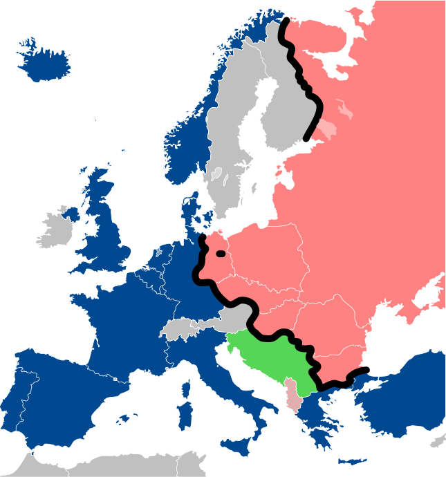
Deutsch: Karte des Eisernen Vorhangs in Europa.
NATO
Warschauer Pakt
Eiserner Vorhang
Neutrale Staaten
Blockfreie Staaten
English: Map of the Iron Curtain in Europe.
NATO
Warsaw Pact
Albania
Iron Curtain
Neutral countries
Non-Aligned
Español: Mapa del Cortina de Hierro en Europa.
es:OTAN
es:Pacto de Varsovia
es:Telón de acero
País neutral
es:Países no alineados
Français : Carte du rideau de fer en Europe.
OTAN
Pacte de Varsovie
Albanie
rideau de fer
Pays Neutre
Non-alignés
Italiano: Mappa della cortina di ferro in Europa.
NATO
Patto di Varsavia
cortina di ferro
Paesi neutrali
Paesi non allineati
Lëtzebuergesch: Kaart vum Westen an dem Ostblock an Europa während dem Kale Krich.
NATO
Warschauer Pakt
"Eise Rido"
Neutral Länner
Net-alignéiert
Polski: Mapa Żelaznej kurtyny w Europie.
NATO
Układ Warszawski
Żelazna kurtyna
Państwa neutralne
Ruch Państw Niezaangażowanych
Slovenščina: Zemljevid železne zavese v Evropi.
NATO
Varšavski pakt
Albanija
železna zavesa
Nevtralne države
Neuvrščeni
Русский: Карта Железного занавеса в Европе.
НАТО
Организация Варшавского договора
Железный занавес
Нейтральные страны
Движение неприсоединения
Українська: Карта Залізної завіси в Європі.
НАТО
Варшавський договір
Залізна завіса
Нейтральні країни
Рух неприєднання
Tarix
Mənbə
Travail personnel (own work). Sources:
Image:Blank_map_of_Europe_cropped.svg by Revolus under licence CC-BY-SA 2.5, itfself from Image:Europe countries.svg by Júlio Reis alias Tintazul, under licence CC-BY-SA 2.5
Image:Cold war europe military alliances map.png by San Jose under licence GFDL
Image:Iron Curtain Final.svg by Vernes Seferovic alias Kseferovic under licence GFDL & CC-BY-SA
Müəllif
Sémhur
Digər versiyalar
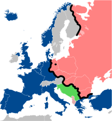
File:Iron Curtain map alternative.svg (Same, but with Yugoslavia on the Eastern side of the Iron Curtain.)
This W3C-unspecified vector image was created with Inkscape…important .
This SVG file contains embedded text that can be translated into your language, using any capable SVG editor, text editor or the SVG Translate tool. For more information see: About translating SVG files.
Graphic Lab
InfoField
Bu xəritə Qrafik emalatxanada (fr) yaradılmışdır. Siz həmçinin təsvirin yaxşılaşması ilə bağlı müraciət edə bilərsiniz.
Camera location
52° 30′ 00″ N, 13° 24′ 00″ E
View this and other nearby images on: OpenStreetMap
52.500000; 13.400000
Lisenziya
I, the copyright holder of this work, hereby publish it under the following licenses:
Copyleft: This work of art is free; you can redistribute it and/or modify it according to terms of the Free Art License. You will find a specimen of this license on the Copyleft Attitude site as well as on other sites. http://artlibre.org/licence/lal/enFALFree Art Licensefalsetrue
This file is licensed under the Creative Commons Attribution-Share Alike 4.0 International, 3.0 Unported, 2.5 Generic, 2.0 Generic and 1.0 Generic license.
Azadsınız:
paylaşmaq – əsəri köçürmək, paylamaq və ötürmək üçün
remiks etmək – əsəri adaptasiya etmək
Aşağıdakı şərtlərə riayət etməklə:
istinad – Müvafiq kredit verməlisiniz, lisenziyaya bir keçid verməlisiniz və dəyişikliklərin olub olmadığını bildirməlisiniz. Bunu hər hansı bir ağlabatan şəkildə edə bilərsiniz, ancaq lisenziyalaşdırıcının sizi və ya istifadənizi təsdiqləməsini təklif edən bir şəkildə deyil.
bənzər paylaşma – Əsəri remix edirsinizsə, dəyişdirirsinizsə və ya üzərində iş aparırsınızsa, öz töhfələrinizi orijinalda olduğu kimi eyni və ya uyğun lisenziya altında yayımlamalısınız.
Extend the Iron Curtain eastwards of Yugoslavia. Even though Yugoslavia was not really considered part of the West, the currenet map gives the false impression that there was a huge gap in the Iron Curtain, which wasn't the case.
{{Information |Description={{en|1=Map of the Iron Curtain in Europe.}} {{fr|1=Carte du rideau de fer en Europe.}} {{es|1=Mapa del Telón de Acero en Europa.}} |Source=Travail personnel (ow
Bu faylda fotoaparat və ya skanerlə əlavə olunmuş məlumatlar var. Əgər fayl sonradan redaktə olunubsa, bəzi parametrlər bu şəkildə göstərilənlərdən fərqli ola bilər.
Genişlik
645
Hündürlük
690
Oktyabr 05, 2023
fayl, iron, curtain, fayl, faylın, tarixçəsi, fayl, keçidləri, faylın, qlobal, istifadəsi, metaməlumatlarbu, faylın, formatındakı, görünüşünün, ölçüsü, piksel, digər, ölçülər, piksel, piksel, piksel, piksel, piksel, piksel, faylın, orijinalı, 8206, faylı, nomi. Fayl Faylin tarixcesi Fayl kecidleri Faylin qlobal istifadesi MetamelumatlarBu SVG faylin PNG formatindaki bu gorunusunun olcusu 560 599 piksel Diger olculer 224 240 piksel 449 480 piksel 718 768 piksel 957 1 024 piksel 1 914 2 048 piksel 645 690 piksel Faylin orijinali 8206 SVG fayli nominal olaraq 645 690 piksel faylin olcusu 322 KB Bu fayl Vikimedia Commons dadirve diger layihelerde istifade edile biler tesvir sehifesi Faylin tesvir sehifesine get Xulase IzahIron Curtain map svg Deutsch Karte des Eisernen Vorhangs in Europa nbsp NATO nbsp Warschauer Pakt nbsp Eiserner Vorhang nbsp Neutrale Staaten nbsp Blockfreie StaatenEnglish Map of the Iron Curtain in Europe nbsp NATO nbsp Warsaw Pact Albania nbsp Iron Curtain nbsp Neutral countries nbsp Non AlignedEspanol Mapa del Cortina de Hierro en Europa nbsp es OTAN nbsp es Pacto de Varsovia nbsp es Telon de acero nbsp Pais neutral nbsp es Paises no alineadosFrancais Carte du rideau de fer en Europe nbsp OTAN nbsp Pacte de Varsovie Albanie nbsp rideau de fer nbsp Pays Neutre nbsp Non alignesItaliano Mappa della cortina di ferro in Europa nbsp NATO nbsp Patto di Varsavia nbsp cortina di ferro nbsp Paesi neutrali nbsp Paesi non allineatiLetzebuergesch Kaart vum Westen an dem Ostblock an Europa wahrend dem Kale Krich nbsp NATO nbsp Warschauer Pakt nbsp Eise Rido nbsp Neutral Lanner nbsp Net aligneiertPolski Mapa Zelaznej kurtyny w Europie nbsp NATO nbsp Uklad Warszawski nbsp Zelazna kurtyna nbsp Panstwa neutralne nbsp Ruch Panstw NiezaangazowanychSlovenscina Zemljevid zelezne zavese v Evropi nbsp NATO nbsp Varsavski pakt Albanija nbsp zelezna zavesa nbsp Nevtralne drzave nbsp NeuvrsceniRusskij Karta Zheleznogo zanavesa v Evrope nbsp NATO nbsp Organizaciya Varshavskogo dogovora nbsp Zheleznyj zanaves nbsp Nejtralnye strany nbsp Dvizhenie neprisoedineniyaUkrayinska Karta Zaliznoyi zavisi v Yevropi nbsp NATO nbsp Varshavskij dogovir nbsp Zalizna zavisa nbsp Nejtralni krayini nbsp Ruh nepriyednannya Tarix 31 may 2008 Menbe Travail personnel own work Sources Image Blank map of Europe cropped svg by Revolus under licence CC BY SA 2 5 itfself from Image Europe countries svg by Julio Reis alias Tintazul under licence CC BY SA 2 5 Image Cold war europe military alliances map png by San Jose under licence GFDL Image Iron Curtain Final svg by Vernes Seferovic alias Kseferovic under licence GFDL amp CC BY SA Muellif Semhur Diger versiyalar File Iron Curtain map alternative svg Same but with Yugoslavia on the Eastern side of the Iron Curtain Istinad required by the license InfoField c Semhur nbsp nbsp Wikimedia Commons nbsp nbsp CC BY SA 4 0 or Free Art LicenseInfoField c Semhur nbsp nbsp Wikimedia Commons SVGInfoField nbsp W3C validity not checked nbsp This W3C unspecified vector image was created with Inkscape important This SVG file contains embedded text that can be translated into your language using any capable SVG editor text editor or the SVG Translate tool For more information see About translating SVG files Graphic LabInfoFieldBu xerite Qrafik emalatxanada fr yaradilmisdir Siz hemcinin tesvirin yaxsilasmasi ile bagli muraciet ede bilersiniz Camera location52 nbsp 30 nbsp 00 nbsp N 13 nbsp 24 nbsp 00 nbsp E nbsp View this and other nearby images on OpenStreetMap52 500000 13 400000 Lisenziya I the copyright holder of this work hereby publish it under the following licenses Copyleft This work of art is free you can redistribute it and or modify it according to terms of the Free Art License You will find a specimen of this license on the Copyleft Attitude site as well as on other sites http artlibre org licence lal en FAL Free Art License false trueThis file is licensed under the Creative Commons Attribution Share Alike 4 0 International 3 0 Unported 2 5 Generic 2 0 Generic and 1 0 Generic license Azadsiniz paylasmaq eseri kocurmek paylamaq ve oturmek ucun remiks etmek eseri adaptasiya etmek Asagidaki sertlere riayet etmekle istinad Muvafiq kredit vermelisiniz lisenziyaya bir kecid vermelisiniz ve deyisikliklerin olub olmadigini bildirmelisiniz Bunu her hansi bir aglabatan sekilde ede bilersiniz ancaq lisenziyalasdiricinin sizi ve ya istifadenizi tesdiqlemesini teklif eden bir sekilde deyil benzer paylasma Eseri remix edirsinizse deyisdirirsinizse ve ya uzerinde is aparirsinizsa oz tohfelerinizi orijinalda oldugu kimi eyni ve ya uygun lisenziya altinda yayimlamalisiniz https creativecommons org licenses by sa 4 0 CC BY SA 4 0 Creative Commons Attribution Share Alike 4 0 true trueIstediyiniz lisenziyani sece bilersiniz CaptionsazerbaycancaAdd a one line explanation of what this file representsingilisMap showing the political division of Europe after World War II ended up until the end of the Cold War polyakZelazna kurtyna w EuropieItems portrayed in this filetesvir ediryaradicisome valueURL https commons wikimedia org wiki user S C3 A9mhurWikimedia username nbsp ingilis Semhurobyektin rolu fotoqrafmuellifin qisa adi Semhurcopyright status nbsp ingiliscopyrighted nbsp ingilislisenziyaFree Art License nbsp ingilisCreative Commons Attribution ShareAlike 2 5 Generic nbsp ingilisCreative Commons Attribution ShareAlike 1 0 Generic nbsp ingilisCreative Commons Attribution ShareAlike 4 0 International nbsp ingilisCreative Commons Attribution ShareAlike 3 0 Unported nbsp ingilisCreative Commons Attribution ShareAlike 2 0 Generic nbsp ingilisyaranma tarixi31 may 2008coordinates of the point of view nbsp ingilis52 30 N 13 24 EMIME type nbsp ingilisimage svg xml Faylin tarixcesi Faylin evvelki versiyasini gormek ucun gun tarix bolmesindeki tarixlere klikleyin Tarix VaxtKicik sekilOlculerIstifadeciSerh indiki13 26 15 dekabr 2022645 690 322 KB PhotographyEditsExtend the Iron Curtain eastwards of Yugoslavia Even though Yugoslavia was not really considered part of the West the currenet map gives the false impression that there was a huge gap in the Iron Curtain which wasn 039 t the case 00 56 23 iyul 2022645 690 321 KB KwamikagamiNATO blue 004990 20 30 30 mart 2019645 690 321 KB SemhurReverted to version as of 07 07 27 May 2014 UTC Albania leaves the Waras Pack in middle of cold war this is why it 039 s shown wtih stripes 09 18 24 mart 2019512 548 123 KB HakuliAlbania leaves the Waras Pack in middle of cold war 07 07 27 may 2014645 690 321 KB SemhurValid SVG 13 51 16 noyabr 2010645 690 321 KB SemhurAdded Iron Curtain between Bulgaria and Greece amp Turkey 16 57 27 sentyabr 2008645 690 321 KB SemhurCorrecting mistake Austria wasn 039 t in NATO 10 51 31 may 2008645 690 330 KB Semhur Information Description en 1 Map of the Iron Curtain in Europe fr 1 Carte du rideau de fer en Europe es 1 Mapa del Telon de Acero en Europa Source Travail personnel ow Fayl kecidleri Bu sekile olan kecidler Demir perde Faylin qlobal istifadesi Bu fayl asagidaki vikilerde istifade olunur af wikipedia org layihesinde istifadesi Ystergordyn als wikipedia org layihesinde istifadesi Europa Westeuropa ar wikipedia org layihesinde istifadesi تاريخ أوروبا ast wikipedia org layihesinde istifadesi Pautu de Varsovia Cortina de Fierro azb wikipedia org layihesinde istifadesi اوروپا تاریخی باتی اوروپا bar wikipedia org layihesinde istifadesi Eiserner Vorhang ba wikipedia org layihesinde istifadesi Evropa be tarask wikipedia org layihesinde istifadesi Varshayskaya damova be wikipedia org layihesinde istifadesi Zhaleznaya zaslona bg wikipedia org layihesinde istifadesi Zhelyazna zavesa br wikipedia org layihesinde istifadesi Brezel Yen bs wikipedia org layihesinde istifadesi Zeljezna zavjesa Historija Njemacke 1945 1990 ca wikipedia org layihesinde istifadesi Guerra Freda Telo d acer cs wikipedia org layihesinde istifadesi Evropa Vychodni blok Socialisticka federativni republika Jugoslavie Zapadni blok cy wikipedia org layihesinde istifadesi Y Llen Haearn da wikipedia org layihesinde istifadesi Kommunisme Jerntaeppet Vesteuropa de wikipedia org layihesinde istifadesi 1946 Westeuropa Ostblock Bewegung der Blockfreien Staaten Eiserner Vorhang Himmeroder Denkschrift Sozialistische Foderative Republik Jugoslawien Diskussion Annexion der Krim 2014 Archiv 002 el wikipedia org layihesinde istifadesi Sidhroyn parapetasma el wiktionary org layihesinde istifadesi sidhroyn parapetasma en wikipedia org layihesinde istifadesi Warsaw Pact Iron Curtain 1946 in the United States Wikipedia Graphics Lab Map workshop Archive Oct 2011 Talk Iron Curtain Archive 1 German refugee policy en wikiquote org layihesinde istifadesi Winston Churchill Joseph Stalin en wiktionary org layihesinde istifadesi Iron Curtain zelezna opona Cuirtear Iarainn jernteppet jarnteppet eo wikipedia org layihesinde istifadesi Fera Kurteno Bu faylin qlobal istifadesine baxin Metamelumatlar Bu faylda fotoaparat ve ya skanerle elave olunmus melumatlar var Eger fayl sonradan redakte olunubsa bezi parametrler bu sekilde gosterilenlerden ferqli ola biler Genislik645Hundurluk690 Menbe https az wikipedia org wiki Fayl Iron Curtain map svg, wikipedia, oxu, kitab, kitabxana, axtar, tap, hersey,
ne axtarsan burda
, en yaxsi meqale sayti, meqaleler, kitablar, oyrenmek, wiki, bilgi, tarix, seks, porno, indir, yukle, sex, azeri sex, azeri, seks yukle, sex yukle, izle, seks izle, porno izle, mobil seks, telefon ucun, chat, azeri chat, tanisliq, tanishliq, azeri tanishliq, sayt, medeni, medeni saytlar, chatlar, mekan, tanisliq mekani, mekanlari, yüklə, pulsuz, pulsuz yüklə, mp3, video, mp4, 3gp, jpg, jpeg, gif, png, şəkil, muisiqi, mahnı, kino, film, kitab, oyun, oyunlar.