Von der Autonomen Region Kurdistans beanspruchte und besetzte Gebiete
Von der Autonomen Region Kurdistans beanspruchte Gebiete
Der Rest des Iraks
Grenzen der Autonomen Region Kurdistans (inkl. der eingegliederten Gebiete)
Grenze vor 2014
English: Location of Kurdistan in Iraq
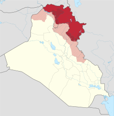
Borders of the Kurdistan Region (disputed)
Pre-2014 borders
Recognised territory of the Kurdistan Region
Disputed territory incorporated into the Kurdistan Region
Other territory claimed and controlled by the Kurdistan Regional Government (approximate)
Other territory claimed by the Kurdistan Regional Government
Rest of Iraq
Español : Ubicación de Kurdistan Iraquí
Fronteras oficiales de la región.
Territorio ocupado por el Kurdistan Iraquí
Territorio reclamado por el Kurdistan Iraquí.
El resto de Irak.
Français : Le Kurdistan irakien en Irak
Frontières officielles du Kurdistan irakien
Territoire incorporé par le Kurdistan irakien
Territoire revendiqué par le Kurdistan irakien
Reste de l'Irak
Magyar: Iraki Kurdisztán területe Irakon belül
Iraki Kurdisztán hivatalos területe
a kurdok által elfoglalt terület (nem hivatalos)
Iraki Kurdisztán által igényelt és elfoglalt terület
Iraki Kurdisztán által igényelt terület
Irak maradék területe
Kurdisztáni Autonóm Régió határa
A határ 2014 előtt
Nederlands: Ligging van Koerdistan in Irak
Officiële grondgebied van Iraaks-Koerdistan
Gebied ingelijfd door Iraaks-Koerdistan
Gebied opgeëist door Iraaks-Koerdistan
Overig Irak
Suomi: Kurdistanin sijainti Irakissa
Irakin Kurdistanin autonominen alue
Irakin Kurdistaniin kuuluvat alueet
Irakin Kurdistanin vaatimat alueet
Irakin valtion hallitsemat alueet
Русский: Курдистан на карте Ирака
Официальные границы автономного региона Иракский Курдистан
Территория, контролируемая силами Иракского Курдистана
Территория, на которую претендует Иракский Курдистан
Прочие территории Ирака
日本語: イラク領クルド人自治区 イラク
イラク中央政府が公式に定めたクルド人自治区の領域
イラク・クルド自治政府が併合し実効支配している領域
イラク・クルド自治政府が領有を主張する領域
その他のイラク国土
中文: 伊拉克的庫德自治區位置 伊拉克
伊拉克庫德自治區的官方邊界
伊拉克庫德自治區的合併領土
伊拉克庫德自治區宣稱所有的領土
伊拉克其餘地區
فارسی : اقلیم کردستان عراق
منطقهٔ رسمی کردستان عراق (در دست دولت کردستان)
بخشهای اشغالشده توسط کردستان عراق
دیگر بخشهای موردادعای کردستان عراق (در دست دولت مرکزی یا در اشغال داعش)
دیگر منطقههای عراق
Tarix
Mənbə
This SVG _?_ includes elements that have been taken or adapted from this _?_:
Iraq location map2.svg (by NordNordWest).
This SVG _?_ includes elements that have been taken or adapted from this _?_:
Southern and western kurdistan.png (by NordNordWest).
.
Müəllif
Spesh531, TUBS
Digər versiyalar
This SVG map is part of a locator map series applying the widespread location map scheme. Please see root category to browse for more.
More ▼
Afrika
Algeria • Angola • Benin • Botswana • Burkina Faso • Burundi • Cameroon • Cape Verde • Central African Republic • Chad • Comoros • Côte d'Ivoire • Democratic Republic of the Congo • Republic of the Congo • Djibouti • Egypt • Equatorial Guinea • Eritrea • Eswatini • Ethiopia • Gabon • Gambia • Ghana • Guinea-Bissau • Guinea • Kenya • Lesotho • Liberia • Libya • Madagascar • Malawi • Mali • Mauritania • Mauritius • Morocco • Mozambique • Namibia • Niger • Nigeria • Rwanda • (Sahrawi Arab Democratic Republic) • Senegal • Seychelles • Sierre Leone • Somalia • Somaliland • South Africa • South Sudan • Sudan • São Tomé and Príncipe • Tanzania • Togo • Tunisia • Uganda • Yemen • Zambia • Zimbabwe
Asiya
(Abkhazia) • Afghanistan • Armenia • Azerbaijan • Bahrain • Bangladesh • Bhutan • Brunei • Cambodia • China • Republic of China • Cyprus • East Timor • Egypt • Georgia • India • Indonesia • Iran • Iraq • Israel • Japan • Jordan • Kazakhstan • Kuwait • Kyrgyzstan • Laos • Lebanon • Malaysia • Maldives • Mongolia • Myanmar • Nepal • North Korea • (Northern Cyprus) • Oman • Pakistan • (Palestine) • Papua New Guinea • Philippines • Qatar • Russia • Saudi Arabia • Singapore • South Korea • (South Ossetia) • Sri Lanka • Syria • Tajikistan • Thailand • Turkey • Turkmenistan • United Arab Emirates • Uzbekistan • Vietnam • Yemen
Avropa
(European Union) • (Abkhazia) • Albania • Andorra • Armenia • Austria • Azerbaijan • Belarus • Belgium • Bosnia and Herzegovina • Bulgaria • Czech Republic • Croatia • Cyprus • Denmark • Estonia • Finland • France • Georgia • Germany • Greece • (Guernsey) • Hungary • Iceland • Ireland • Italy • (Jersey) • Kazakhstan • (Kosovo) • Latvia • Liechtenstein • Lithuania • Luxembourg • Malta • (Isle of Man) • Moldova • Monaco • Montenegro • Netherlands • North Macedonia • (Northern Cyprus) • Norway • Poland • Portugal • Romania • Russia • San Marino • Serbia • Slovakia • Slovenia • (South Ossetia) • Spain • Sweden • Switzerland • Turkey • Ukraine • United Kingdom • Vatican City
Şimali Amerika
Antigua and Barbuda • Bahamas • Barbados • Belize • Canada • Costa Rica • Cuba • Dominica • Dominican Republic • El Salvador • Grenada • Guatemala • Haiti • Honduras • Iceland • Jamaica • Mexico • Nicaragua • Panama • Saint Kitts and Nevis • Saint Lucia • Saint Vincent and the Grenadines • Trinidad and Tobago • United States
Okeaniya
Australia • (Cook Islands) • Fiji • Indonesia • Kiribati • Marshall Islands • Micronesia • Nauru • New Zealand • (Niue) • Palau • Papua New Guinea • Samoa • Solomon Islands • Tonga • Tuvalu • Vanuatu
Cənubi Amerika
Argentina • Bolivia • Brazil • Chile • Colombia • Ecuador • Guyana • Panama • Paraguay • Peru • Suriname • Trinidad and Tobago • Uruguay • Venezuela
Antarktida
-
Locator maps design recommendations ▼
Principles
Design Guidelines are based on ▸location map design of the German map shop (in German). It's preferable to derive new locator maps from existing location maps. Please keep both size and ratio in this case. Thus the new locator maps may still be applied as location map (▸Guide). Marker color is supposed to be darkred. Waterbodies may be transparent, to show other objects better. Please be aware that this guide is only a recommendation. It’s not an inevitable law!
Color template
Template toolbox
Other optional map elements
Subdivision of a country
Country within an international organization
Country without context projected on the globe
Country without context
Highlight small areas
Marker
Merged markers
“Glowing” edges
Zoom
Zoom
Zoom
“Remote” areas and mini maps
Mini maps show where the depicted area actually is situated. Check out ▸Vorlage:Positionskarte+ (in German) and ▸Modèle:Carte en coin (in French) of how to insert a mini map in virtually every map.
Small maps apply different scales
Small map applies same scale as main map
Mini map with box
Depicted continent dark grey
Zoomed box on a world map also showing the remote part of country
Disputed areas
rest of Serbia: foreign or the same country?
Kosovo: part of Serbia?
Whether South Ossetia or Abkhazia form a part of Georgia is disputed. The marked Georgian administrative region however is partly under Georgian control (solid red) while other parts are part break-away "country" South Ossetia (hatched).
India claims some northern areas (hatched) while other areas are controlled by India but challenged by other countries. India claims all of Kashmir (red areas), while it controls only the southern part of it (cf. broad red stripes vs. narrow red stripes).
Western Sahara: part of Morocco?
Like above. However, the map differentiates whether the disputed area is controlled by Morocco or not.
Locator map of Taiwan in China. Map hatches all areas that are claimed but not controlled by China. Hence, highlighted Taiwan is also hatched grey/red.
Greyed special objects
Glaciers
Urbanized areas
Backgrounds
Relief
Relief (like before, but outlines highlighted)
Satellite view
Land cover
Relief
Corresponding imagemaps ▼
Afrika
Algeria • Angola • Benin • Botswana • Burkina Faso • Burundi • Cameroon • Cape Verde • Central African Republic • Chad • Comoros • Côte d'Ivoire • Democratic Republic of the Congo • Repbulic of the Congo • Djibouti • Egypt • Equatorial Guinea • Eritrea • Ethiopia • Gabon • Gambia • Ghana • Guinea-Bissau • Guinea • Kenya • Lesotho • Liberia • Libya • Madagascar • Malawi • Mali • Mauritania • Mauritius • Morocco • Mozambique • Namibia • Niger • Nigeria • Rwanda • (Sahrawi Arab Democratic Republic) • Senegal • Seychelles • Sierre Leone • Somalia • South Africa • South Sudan • Sudan • Swaziland • São Tomé and Príncipe • Tanzania • Togo • Tunisia • Uganda • Yemen • Zambia • Zimbabwe
Asiya
(Abkhazia) • Afghanistan • Armenia • Azerbaijan • Bahrain • Bangladesh • Bhutan • Brunei • Cambodia • China• Republic of China • Cyprus • East Timor • Egypt • Georgia • India • Indonesia • Iran • Iraq • Israel • Japan • Jordan • Kazakhstan • Kuwait • Kyrgyzstan • Laos • Lebanon • Malaysia • Maldives • Mongolia • Myanmar • Nepal • North Korea • (Northern Cyprus) • Oman • Pakistan • (Palestine) • Papua New Guinea• Philippines • Qatar • Russia • Saudi Arabia • Singapore • South Korea • (South Ossetia) • Sri Lanka • Syria • Tajikistan • Thailand • Turkey • Turkmenistan• United Arab Emirates • Uzbekistan • Vietnam • Yemen
Avropa
(Abkhazia) • Albania • Andorra • Armenia • Austria • Azerbaijan • Belarus • Belgium • Bosnia and Herzegovina • Bulgaria • Czech Republic • Croatia • Cyprus • Denmark • Estonia • Finland • France • Georgia • Germany • Greece • (Guernsey) • Hungary • Iceland • Ireland • Italy • (Jersey) • Kazakhstan • (Kosovo) • Latvia • Liechtenstein • Lithuania • Luxembourg • Macedonia • Malta • (Isle of Man) • Moldova • Monaco • Montenegro • Netherlands • (Northern Cyprus) • Norway • Poland • Portugal • Romania • Russia • San Marino • Serbia • Slovakia • Slovenia • (South Ossetia) • Spain • Sweden • Switzerland • Turkey • Ukraine • United Kingdom • Vatican City
Şimali Amerika
Antigua and Barbuda • Bahamas • Barbados • Belize • Canada • Costa Rica • Cuba • Dominica • Dominican Republic • El Salvador • Grenada • Guatemala • Haiti • Honduras • Iceland • Jamaica • Mexico • Nicaragua • Panama • Saint Kitts and Nevis • Saint Lucia • Saint Vincent and the Grenadines • Trinidad and Tobago • United States
Okeaniya
Australia • Brunei • (Cook Islands) • East Timor • Fiji • Indonesia • Kiribati • Marshall Islands • Micronesia • Nauru • New Zealand • (Niue) • Palau • Papua New Guinea • Samoa • Solomon Islands • Tonga • Tuvalu • Vanuatu
Cənubi Amerika
Argentina • Bolivia • Brazil • Chile • Colombia • Ecuador • Guyana • Panama • Paraguay • Peru • Suriname • Trinidad and Tobago • Uruguay • Venezuela
Other
Antarktida
World map
Qlobus
SVG genesis
InfoField
The source code of this SVG is invalid due to 4 errors.
This W3C-invalid locator map was created with Inkscape…important by NordNordWest.
Lisenziya
Bu fayl Creative Commons Attribution-Share Alike 3.0 Sinqapur lisenziyası altında yayımlanır.
Azadsınız:
paylaşmaq – əsəri köçürmək, paylamaq və ötürmək üçün
remiks etmək – əsəri adaptasiya etmək
Aşağıdakı şərtlərə riayət etməklə:
istinad – Müvafiq kredit verməlisiniz, lisenziyaya bir keçid verməlisiniz və dəyişikliklərin olub olmadığını bildirməlisiniz. Bunu hər hansı bir ağlabatan şəkildə edə bilərsiniz, ancaq lisenziyalaşdırıcının sizi və ya istifadənizi təsdiqləməsini təklif edən bir şəkildə deyil.
bənzər paylaşma – Əsəri remix edirsinizsə, dəyişdirirsinizsə və ya üzərində iş aparırsınızsa, öz töhfələrinizi orijinalda olduğu kimi eyni və ya uyğun lisenziya altında yayımlamalısınız.
The town of Makhmur was taken over by Iraqi forces last year. Also the frontier in Kirkuk likely corresponds to the 2003 green line, not the administrative border, since Iraq only requested the Kurdish forces withdraw to the green line.
Update following Peshmerga withdrawal from a number of areas. Note Kurdish militias (eg PKK, YBS, etc.) have not withdrew from all areas, but they are not under KRG control. Approximate area, will need to be updated.
Bu faylda fotoaparat və ya skanerlə əlavə olunmuş məlumatlar var. Əgər fayl sonradan redaktə olunubsa, bəzi parametrlər bu şəkildə göstərilənlərdən fərqli ola bilər.
Genişlik
1240.813
Hündürlük
1264.1963
Dekabr 31, 2022
fayl, iraqi, kurdistan, iraq, facto, disputed, hatched, fayl, faylın, tarixçəsi, istifadə, edilən, səhifələr, faylın, qlobal, istifadəsi, metaməlumatlarbu, faylın, formatındakı, görünüşünün, ölçüsü, piksel, digər, ölçülər, piksel, piksel, piksel, piksel, pikse. Fayl Faylin tarixcesi Istifade edilen sehifeler Faylin qlobal istifadesi MetamelumatlarBu SVG faylin PNG formatindaki bu gorunusunun olcusu 589 600 piksel Diger olculer 236 240 piksel 471 480 piksel 754 768 piksel 1 005 1 024 piksel 2 011 2 048 piksel 1 241 1 264 piksel Faylin orijinali 8206 SVG fayli nominal olaraq 1 241 1 264 piksel faylin olcusu 545 KB Bu fayl Vikimedia Commons dadirve diger layihelerde istifade edile biler Faylin tesvir sehifesine get Xulase IzahIraqi Kurdistan in Iraq de facto and disputed hatched svg Ban lam gu Kurdistan ti Iraq e ui ti Iraq koaⁿ hong teng e Kurdistan Te he k Iraq Kurdistan khong che e tho te Iraq Kurdistan chu tiuⁿ e tho te Iraq ki tha pō hunCatala Kurdistan Iraqui Limits oficials de la regio kurda Territori controlat pel Kurdistan Iraqui Territory reivindicat pel Kurdistan IraquiDansk Kort over Irakisk Kurdistan i Irak Officielle graenser for Regionen Irakisk Kurdistan Andre omrader kontrolleret af Irakisk Kurdistan Territorier som Irakisk Kurdistan gor krav pa Ovrige IrakDeutsch Die Lage Kurdistans im Irak Offizielles Gebiet der Autonomen Region Kurdistan Eingegliederte Gebiete nicht offiziell anerkannt Von der Autonomen Region Kurdistans beanspruchte und besetzte GebieteVon der Autonomen Region Kurdistans beanspruchte Gebiete Der Rest des Iraks Grenzen der Autonomen Region Kurdistans inkl der eingegliederten Gebiete Grenze vor 2014English Location of Kurdistan in Iraq Borders of the Kurdistan Region disputed Pre 2014 borders Recognised territory of the Kurdistan Region Disputed territory incorporated into the Kurdistan Region Other territory claimed and controlled by the Kurdistan Regional Government approximate Other territory claimed by the Kurdistan Regional Government Rest of IraqEspanol Ubicacion de Kurdistan Iraqui Fronteras oficiales de la region Territorio ocupado por el Kurdistan Iraqui Territorio reclamado por el Kurdistan Iraqui El resto de Irak Francais Le Kurdistan irakien en Irak Frontieres officielles du Kurdistan irakien Territoire incorpore par le Kurdistan irakien Territoire revendique par le Kurdistan irakien Reste de l IrakMagyar Iraki Kurdisztan terulete Irakon belul Iraki Kurdisztan hivatalos terulete a kurdok altal elfoglalt terulet nem hivatalos Iraki Kurdisztan altal igenyelt es elfoglalt teruletIraki Kurdisztan altal igenyelt terulet Irak maradek terulete Kurdisztani Autonom Regio hatara A hatar 2014 elottNederlands Ligging van Koerdistan in Irak Officiele grondgebied van Iraaks Koerdistan Gebied ingelijfd door Iraaks Koerdistan Gebied opgeeist door Iraaks Koerdistan Overig IrakSuomi Kurdistanin sijainti Irakissa Irakin Kurdistanin autonominen alue Irakin Kurdistaniin kuuluvat alueet Irakin Kurdistanin vaatimat alueet Irakin valtion hallitsemat alueetRusskij Kurdistan na karte Iraka Oficialnye granicy avtonomnogo regiona Irakskij Kurdistan Territoriya kontroliruemaya silami Irakskogo Kurdistana Territoriya na kotoruyu pretenduet Irakskij Kurdistan Prochie territorii Iraka日本語 イラク領クルド人自治区 イラク イラク中央政府が公式に定めたクルド人自治区の領域 イラク クルド自治政府が併合し実効支配している領域 イラク クルド自治政府が領有を主張する領域 その他のイラク国土中文 伊拉克的庫德自治區位置 伊拉克 伊拉克庫德自治區的官方邊界 伊拉克庫德自治區的合併領土 伊拉克庫德自治區宣稱所有的領土 伊拉克其餘地區فارسی اقلیم کردستان عراق منطقه رسمی کردستان عراق در دست دولت کردستان بخش های اشغال شده توسط کردستان عراق دیگر بخش های موردادعای کردستان عراق در دست دولت مرکزی یا در اشغال داعش دیگر منطقه های عراقTarix 28 iyun 2014Menbe This SVG includes elements that have been taken or adapted from this Iraq location map2 svg by NordNordWest This SVG includes elements that have been taken or adapted from this Southern and western kurdistan png by NordNordWest Muellif Spesh531 TUBSDiger versiyalar This SVG map is part of a locator map series applying the widespread location map scheme Please see root category to browse for more More AfrikaAlgeria Angola Benin Botswana Burkina Faso Burundi Cameroon Cape Verde Central African Republic Chad Comoros Cote d Ivoire Democratic Republic of the Congo Republic of the Congo Djibouti Egypt Equatorial Guinea Eritrea Eswatini Ethiopia Gabon Gambia Ghana Guinea Bissau Guinea Kenya Lesotho Liberia Libya Madagascar Malawi Mali Mauritania Mauritius Morocco Mozambique Namibia Niger Nigeria Rwanda Sahrawi Arab Democratic Republic Senegal Seychelles Sierre Leone Somalia Somaliland South Africa South Sudan Sudan Sao Tome and Principe Tanzania Togo Tunisia Uganda Yemen Zambia ZimbabweAsiya Abkhazia Afghanistan Armenia Azerbaijan Bahrain Bangladesh Bhutan Brunei Cambodia China Republic of China Cyprus East Timor Egypt Georgia India Indonesia Iran Iraq Israel Japan Jordan Kazakhstan Kuwait Kyrgyzstan Laos Lebanon Malaysia Maldives Mongolia Myanmar Nepal North Korea Northern Cyprus Oman Pakistan Palestine Papua New Guinea Philippines Qatar Russia Saudi Arabia Singapore South Korea South Ossetia Sri Lanka Syria Tajikistan Thailand Turkey Turkmenistan United Arab Emirates Uzbekistan Vietnam YemenAvropa European Union Abkhazia Albania Andorra Armenia Austria Azerbaijan Belarus Belgium Bosnia and Herzegovina Bulgaria Czech Republic Croatia Cyprus Denmark Estonia Finland France Georgia Germany Greece Guernsey Hungary Iceland Ireland Italy Jersey Kazakhstan Kosovo Latvia Liechtenstein Lithuania Luxembourg Malta Isle of Man Moldova Monaco Montenegro Netherlands North Macedonia Northern Cyprus Norway Poland Portugal Romania Russia San Marino Serbia Slovakia Slovenia South Ossetia Spain Sweden Switzerland Turkey Ukraine United Kingdom Vatican CitySimali AmerikaAntigua and Barbuda Bahamas Barbados Belize Canada Costa Rica Cuba Dominica Dominican Republic El Salvador Grenada Guatemala Haiti Honduras Iceland Jamaica Mexico Nicaragua Panama Saint Kitts and Nevis Saint Lucia Saint Vincent and the Grenadines Trinidad and Tobago United StatesOkeaniyaAustralia Cook Islands Fiji Indonesia Kiribati Marshall Islands Micronesia Nauru New Zealand Niue Palau Papua New Guinea Samoa Solomon Islands Tonga Tuvalu VanuatuCenubi AmerikaArgentina Bolivia Brazil Chile Colombia Ecuador Guyana Panama Paraguay Peru Suriname Trinidad and Tobago Uruguay VenezuelaAntarktida Locator maps design recommendations Principles Design Guidelines are based on location map design of the German map shop in German It s preferable to derive new locator maps from existing location maps Please keep both size and ratio in this case Thus the new locator maps may still be applied as location map Guide Marker color is supposed to be darkred Waterbodies may be transparent to show other objects better Please be aware that this guide is only a recommendation It s not an inevitable law Color template Template toolbox Other optional map elements Subdivision of a country Country within an international organization Country without context projected on the globe Country without contextHighlight small areas Marker Merged markers Glowing edges Zoom Zoom Zoom Remote areas and mini maps Mini maps show where the depicted area actually is situated Check out Vorlage Positionskarte in German and Modele Carte en coin in French of how to insert a mini map in virtually every map Small maps apply different scales Small map applies same scale as main map Mini map with box Depicted continent dark grey Zoomed box on a world map also showing the remote part of countryDisputed areas rest of Serbia foreign or the same country Kosovo part of Serbia Whether South Ossetia or Abkhazia form a part of Georgia is disputed The marked Georgian administrative region however is partly under Georgian control solid red while other parts are part break away country South Ossetia hatched India claims some northern areas hatched while other areas are controlled by India but challenged by other countries India claims all of Kashmir red areas while it controls only the southern part of it cf broad red stripes vs narrow red stripes Western Sahara part of Morocco Like above However the map differentiates whether the disputed area is controlled by Morocco or not Locator map of Taiwan in China Map hatches all areas that are claimed but not controlled by China Hence highlighted Taiwan is also hatched grey red Greyed special objects Glaciers Urbanized areasBackgrounds Relief Relief like before but outlines highlighted Satellite view Land cover ReliefCorresponding imagemaps AfrikaAlgeria Angola Benin Botswana Burkina Faso Burundi Cameroon Cape Verde Central African Republic Chad Comoros Cote d Ivoire Democratic Republic of the Congo Repbulic of the Congo Djibouti Egypt Equatorial Guinea Eritrea Ethiopia Gabon Gambia Ghana Guinea Bissau Guinea Kenya Lesotho Liberia Libya Madagascar Malawi Mali Mauritania Mauritius Morocco Mozambique Namibia Niger Nigeria Rwanda Sahrawi Arab Democratic Republic Senegal Seychelles Sierre Leone Somalia South Africa South Sudan Sudan Swaziland Sao Tome and Principe Tanzania Togo Tunisia Uganda Yemen Zambia ZimbabweAsiya Abkhazia Afghanistan Armenia Azerbaijan Bahrain Bangladesh Bhutan Brunei Cambodia China Republic of China Cyprus East Timor Egypt Georgia India Indonesia Iran Iraq Israel Japan Jordan Kazakhstan Kuwait Kyrgyzstan Laos Lebanon Malaysia Maldives Mongolia Myanmar Nepal North Korea Northern Cyprus Oman Pakistan Palestine Papua New Guinea Philippines Qatar Russia Saudi Arabia Singapore South Korea South Ossetia Sri Lanka Syria Tajikistan Thailand Turkey Turkmenistan United Arab Emirates Uzbekistan Vietnam YemenAvropa Abkhazia Albania Andorra Armenia Austria Azerbaijan Belarus Belgium Bosnia and Herzegovina Bulgaria Czech Republic Croatia Cyprus Denmark Estonia Finland France Georgia Germany Greece Guernsey Hungary Iceland Ireland Italy Jersey Kazakhstan Kosovo Latvia Liechtenstein Lithuania Luxembourg Macedonia Malta Isle of Man Moldova Monaco Montenegro Netherlands Northern Cyprus Norway Poland Portugal Romania Russia San Marino Serbia Slovakia Slovenia South Ossetia Spain Sweden Switzerland Turkey Ukraine United Kingdom Vatican CitySimali AmerikaAntigua and Barbuda Bahamas Barbados Belize Canada Costa Rica Cuba Dominica Dominican Republic El Salvador Grenada Guatemala Haiti Honduras Iceland Jamaica Mexico Nicaragua Panama Saint Kitts and Nevis Saint Lucia Saint Vincent and the Grenadines Trinidad and Tobago United StatesOkeaniyaAustralia Brunei Cook Islands East Timor Fiji Indonesia Kiribati Marshall Islands Micronesia Nauru New Zealand Niue Palau Papua New Guinea Samoa Solomon Islands Tonga Tuvalu VanuatuCenubi AmerikaArgentina Bolivia Brazil Chile Colombia Ecuador Guyana Panama Paraguay Peru Suriname Trinidad and Tobago Uruguay VenezuelaOtherAntarktida World map QlobusSVG genesisInfoField The source code of this SVG is invalid due to 4 errors This W3C invalid locator map was created with Inkscape important by NordNordWest Lisenziya Bu fayl Creative Commons Attribution Share Alike 3 0 Sinqapur lisenziyasi altinda yayimlanir Azadsiniz paylasmaq eseri kocurmek paylamaq ve oturmek ucun remiks etmek eseri adaptasiya etmek Asagidaki sertlere riayet etmekle istinad Muvafiq kredit vermelisiniz lisenziyaya bir kecid vermelisiniz ve deyisikliklerin olub olmadigini bildirmelisiniz Bunu her hansi bir aglabatan sekilde ede bilersiniz ancaq lisenziyalasdiricinin sizi ve ya istifadenizi tesdiqlemesini teklif eden bir sekilde deyil benzer paylasma Eseri remix edirsinizse deyisdirirsinizse ve ya uzerinde is aparirsinizsa oz tohfelerinizi orijinalda oldugu kimi eyni ve ya uygun lisenziya altinda yayimlamalisiniz https creativecommons org licenses by sa 3 0 CC BY SA 3 0 Creative Commons Attribution Share Alike 3 0 true true References Official territory and governorate borders http www krso net Default aspx page article amp id 1142 http www economist com images 20070908 CMA980 gifClaimed territory http www aina org reports pcok pdf page 13 http www economist com images 20070908 CMA980 gif http photos1 blogger com blogger 6564 131 1600 Kurdistan july05 claimed 767346 jpg http images fastcompany com magazine 144 feature 84 Kurdistan OilMap pop jpg http news bbcimg co uk media images 76876000 gif 76876578 iraq kurdistan 624 gifCaptionsazerbaycancaAdd a one line explanation of what this file representsItems portrayed in this filetesvir edircopyright status ingiliscopyrighted ingilislisenziyaCreative Commons Attribution ShareAlike 3 0 Unported ingilisyaranma tarixi28 iyun 2014MIME type ingilisimage svg xml Faylin tarixcesi Faylin evvelki versiyasini gormek ucun gun tarix bolmesindeki tarixlere klikleyin en yeni en evvelki Goster 10 daha yeni 10 daha kohne 10 20 50 100 250 500 Tarix VaxtKicik sekilOlculerIstifadeciSerh indiki23 01 19 iyul 20181 241 1 264 545 KB Rob984dashed official KRG border on the basis that it 039 s disputed by Baghdad 19 05 19 iyul 20181 241 1 264 548 KB Rob984Also Iraqi forces took Khanaqin in October as well 18 12 19 iyul 20181 241 1 264 549 KB Rob984The town of Makhmur was taken over by Iraqi forces last year Also the frontier in Kirkuk likely corresponds to the 2003 green line not the administrative border since Iraq only requested the Kurdish forces withdraw to the green line 22 34 26 yanvar 20181 241 1 264 549 KB 0ali1Update 26 01 2018 minor fixes 23 55 24 oktyabr 20171 241 1 264 549 KB Rob984Federal government has reassumed control over most if not all of the Kirkuk province 16 03 24 oktyabr 20171 241 1 264 549 KB Rob984Scaled back changes around Machmur Peshmerga have not withdrawn from the town despite earlier reports suggesting so 12 26 20 oktyabr 20171 241 1 264 549 KB Rob984Update following Peshmerga withdrawal from a number of areas Note Kurdish militias eg PKK YBS etc have not withdrew from all areas but they are not under KRG control Approximate area will need to be updated 20 20 12 oktyabr 20171 241 1 264 555 KB Spesh531Update now that ISIS is no longer on the Iraqi Kurdish Iraqi proper border 14 28 28 sentyabr 20171 241 1 264 555 KB Rob984another minor fix 13 20 28 sentyabr 20171 241 1 264 555 KB Rob984minor fix en yeni en evvelki Goster 10 daha yeni 10 daha kohne 10 20 50 100 250 500 Istifade edilen sehifeler Bu sekile olan kecidler Kurdustanin musteqilliyi uzre referendum 2017 Iraq Kurdustani Erbile raket hucumu 2021 Faylin qlobal istifadesi Bu fayl asagidaki vikilerde istifade olunur als wikipedia org layihesinde istifadesi Autonome Region Kurdistan ar wikipedia org layihesinde istifadesi العراق كردستان العراق المناطق المتنازع عليها في العراق كوردستان العراق استفتاء انفصال كردستان العراق 2017 arz wikipedia org layihesinde istifadesi كردستان العراق azb wikipedia org layihesinde istifadesi عراق کوردوستانی قوزئی عیراق سالدیریسی ۲۰۱۴ ba wikipedia org layihesinde istifadesi Kurdistan Tobәk Hokүmәte bcl wikipedia org layihesinde istifadesi Rona nin Iraking Kurdistan be tarask wikipedia org layihesinde istifadesi Iracki Kurdystan be wikipedia org layihesinde istifadesi Irakski Kurdystan bg wikipedia org layihesinde istifadesi Irakski Kyurdistan bn wikipedia org layihesinde istifadesi ইর ক ক র দ স ত ন br wikipedia org layihesinde istifadesi Kurdistan Irak bs wikipedia org layihesinde istifadesi Iracki Kurdistan ceb wikipedia org layihesinde istifadesi Kurdistan ckb wikipedia org layihesinde istifadesi ھەرێمی کوردستان مێژووی کورد داڕێژە Location map Iraqi Kurdistan de facto دەروازە کوردستان لێدوانی دەروازە ڕووداوە بەردەوامەکان ڕێفراندۆمی سەربەخۆییی باشووری کوردستان ٢٠١٧ دەروازە کوردستان وتاری ھەڵبژێردراو دەروازە کوردستان وتاری ھەڵبژێردراو ٢ cs wikipedia org layihesinde istifadesi Iracky Kurdistan cy wikipedia org layihesinde istifadesi Cyrdistan Iracaidd da wikipedia org layihesinde istifadesi Kurdistan Irak de wikipedia org layihesinde istifadesi Autonome Region Kurdistan Wikipedia Kartenwerkstatt Archiv 2016 07 Umstrittene Gebiete des Nordiraks diq wikipedia org layihesinde istifadesi Kurdkerdis el wikipedia org layihesinde istifadesi Irakino Koyrdistan Irakino Koyrdiko dhmopshfisma ane3arthsias 2017 el wikivoyage org layihesinde istifadesi Irakino Koyrdistan en wikipedia org layihesinde istifadesi Iraqi Kurdistan Kurdistan Region Minorities in Iraq 2008 Turkish incursion into northern Iraq List of active separatist movements in Asia Disputed territories of Northern Iraq Northern Iraq offensive June 2014 Talk Iraqi Kurdistan Archive 2 COVID 19 pandemic in the Kurdistan Region eo wikipedia org layihesinde istifadesi Aŭtonoma Regiono Kurdistano es wikipedia org layihesinde istifadesi Kurdistan iraqui Referendum de independencia del Kurdistan iraqui de 2017 et wikipedia org layihesinde istifadesi Iraagi Kurdistan fa wikipedia org layihesinde istifadesi اقلیم کردستان عراق Bu faylin qlobal istifadesine baxin Metamelumatlar Bu faylda fotoaparat ve ya skanerle elave olunmus melumatlar var Eger fayl sonradan redakte olunubsa bezi parametrler bu sekilde gosterilenlerden ferqli ola biler Genislik1240 813Hundurluk1264 1963 Menbe https az wikipedia org wiki Fayl Iraqi Kurdistan in Iraq de facto and disputed hatched svg, wikipedia, oxu, kitab, kitabxana, axtar, tap, hersey,
ne axtarsan burda
, en yaxsi meqale sayti, meqaleler, kitablar, oyrenmek, wiki, bilgi, tarix, seks, porno, indir, yukle, sex, azeri sex, azeri, seks yukle, sex yukle, izle, seks izle, porno izle, mobil seks, telefon ucun, chat, azeri chat, tanisliq, tanishliq, azeri tanishliq, sayt, medeni, medeni saytlar, chatlar, mekan, tanisliq mekani, mekanlari, yüklə, pulsuz, pulsuz yüklə, mp3, video, mp4, 3gp, jpg, jpeg, gif, png, şəkil, muisiqi, mahnı, kino, film, kitab, oyun, oyunlar.
.svg.html)