Bu fayl "Vikimedia Commons"dadır və digər layihələrdə istifadə edilə bilər.
Faylın təsvir səhifəsinə get
Xülasə
İzahIceberg A22A, South Atlantic Ocean.jpg
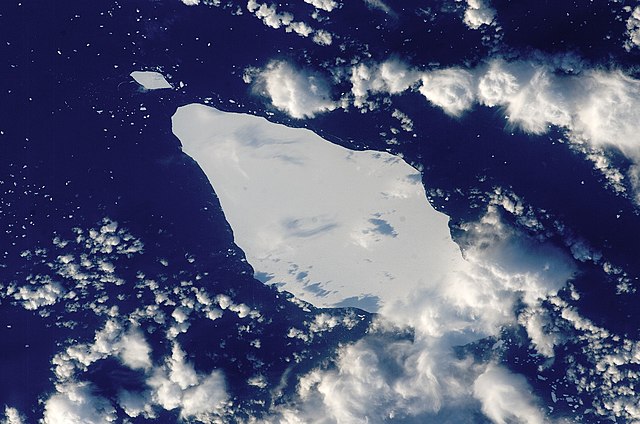
English: This astronaut photograph illustrates the remains of a giant iceberg—designated A22A— that broke off Antarctica in 2002. The iceberg was photographed at a location of 49.9 degrees south latitude, 23.8 degrees west longitude, which is about a third of the distance from South America towards Cape Town, South Africa. A22A is one of the largest icebergs to drift as far north as 50 degrees south latitude, bringing it beneath the daylight path of the International Space Station (ISS). Crew members aboard the ISS were able to locate the ice mass and photograph it, despite the great masses of clouds that often accompany winter storms in the Southern Ocean. The crew’s viewing angle was oblique (not looking straight down) from a point to the west of the berg, and the time of day was early afternoon, as shown by the orientation of the cloud shadows. Dimensions of A22A in early June were 49.9 by 23.4 kilometres, giving it an area of 622 square kilometres, or seven times the area of Manhattan Island.
ISS Crew Earth Observations: ISS015-E-10125
Identification
Mission
ISS015 (Expedition 15)
Roll
E
Frame
10125
Country or Geographic Name
ATLANTIC OCEAN
Features
A22A ICEBERG, SMALL ICEBERGS
Center Point Latitude
-48.8° N
Center Point Longitude
-24.0° E
Camera
Camera Tilt
43°
Camera Focal Length
180 mm
Camera
Kodak DCS760C Electronic Still Camera
Film
3060 x 2036 pixel CCD, RGBG array.
Quality
Percentage of Cloud Cover
26-50%
Nadir What is Nadir?
Date
2007-05-30
Time
14:46:44
Nadir Point Latitude
-50.5° N
Nadir Point Longitude
-21.8° E
Nadir to Photo Center Direction
Northwest
Sun Azimuth
340°
Spacecraft Altitude
181 nautical miles (335 km)
Sun Elevation Angle
16°
Orbit Number
799
Tarix
Mənbə
{{URL|example.com|optional display text}}
Müəllif
Image provided by the ISS Crew Earth Observations experiment and the Image Science & Analysis Laboratory, NASA - Johnson Space Center.
Object location
48° 48′ 00″ S, 24° 00′ 00″ W
View this and other nearby images on: OpenStreetMap
-48.800000; -24.000000
This image or video was catalogued by Johnson Space Center of the United States National Aeronautics and Space Administration (NASA) under Photo ID: ISS015-E-10125.
This tag does not indicate the copyright status of the attached work. A normal copyright tag is still required.See Commons:Licensing.العربية ∙ беларуская (тарашкевіца) ∙ български ∙ català ∙ čeština ∙ dansk ∙ Deutsch ∙ English ∙ español ∙ فارسی ∙ français ∙ galego ∙ magyar ∙ հայերեն ∙ Bahasa Indonesia ∙ italiano ∙ 日本語 ∙ македонски ∙ മലയാളം ∙ Nederlands ∙ polski ∙ português ∙ русский ∙ sicilianu ∙ Türkçe ∙ українська ∙ 简体中文 ∙ 繁體中文 ∙ +/−
Lisenziya
Public domainPublic domainfalsefalse
Captions
Add a one-line explanation of what this file represents
Items portrayed in this file
təsvir edir
copyright status ingilis
ictimai varidat
determination method ingilis: work of the federal government of the United States ingilis
yaranma tarixi
18 iyun 2007
coordinates of depicted place ingilis
48°48'S, 24°0'W
kataloq kodu
ISS015-E-10125
kataloq: Media catalogue of the Johnson Space Center ingilis
əhəmiyyətli hadisə
Expedition 15 ingilis
Faylın tarixçəsi
Faylın əvvəlki versiyasını görmək üçün gün/tarix bölməsindəki tarixlərə klikləyin.
{{Information |Description={{en|1=This astronaut photograph illustrates the remains of a giant iceberg—designated A22A— that broke off Antarctica in 2002. The iceberg was photographed at a location of 49.9 degrees south latitude, 23.8 degrees west lon
Scienze della Terra per le superiori/I movimenti delle acque oceaniche
it.wikiversity.org layihəsində istifadəsi
I movimenti delle acque oceaniche (superiori)
பனிமலை
Yanvar 14, 2023
fayl, iceberg, a22a, south, atlantic, ocean, fayl, faylın, tarixçəsi, istifadə, edilən, səhifələr, faylın, qlobal, istifadəsisınaq, göstərişi, ölçüsü, piksel, digər, ölçülər, piksel, piksel, piksel, piksel, piksel, faylın, orijinalı, 8206, piksel, fayl, həcmi,. Fayl Faylin tarixcesi Istifade edilen sehifeler Faylin qlobal istifadesiSinaq gosterisi olcusu 800 530 piksel Diger olculer 320 212 piksel 640 424 piksel 1 024 678 piksel 1 280 848 piksel 2 345 1 553 piksel Faylin orijinali 8206 2 345 1 553 piksel fayl hecmi 793 KB MIME novu image jpeg Bu fayl Vikimedia Commons dadirve diger layihelerde istifade edile biler Faylin tesvir sehifesine get Xulase IzahIceberg A22A South Atlantic Ocean jpg English This astronaut photograph illustrates the remains of a giant iceberg designated A22A that broke off Antarctica in 2002 The iceberg was photographed at a location of 49 9 degrees south latitude 23 8 degrees west longitude which is about a third of the distance from South America towards Cape Town South Africa A22A is one of the largest icebergs to drift as far north as 50 degrees south latitude bringing it beneath the daylight path of the International Space Station ISS Crew members aboard the ISS were able to locate the ice mass and photograph it despite the great masses of clouds that often accompany winter storms in the Southern Ocean The crew s viewing angle was oblique not looking straight down from a point to the west of the berg and the time of day was early afternoon as shown by the orientation of the cloud shadows Dimensions of A22A in early June were 49 9 by 23 4 kilometres giving it an area of 622 square kilometres or seven times the area of Manhattan Island ISS Crew Earth Observations ISS015 E 10125 IdentificationMission ISS015 Expedition 15 Roll EFrame 10125Country or Geographic Name ATLANTIC OCEANFeatures A22A ICEBERG SMALL ICEBERGSCenter Point Latitude 48 8 NCenter Point Longitude 24 0 ECameraCamera Tilt 43 Camera Focal Length 180 mmCamera Kodak DCS760C Electronic Still CameraFilm 3060 x 2036 pixel CCD RGBG array QualityPercentage of Cloud Cover 26 50 Nadir What is Nadir Date 2007 05 30Time 14 46 44Nadir Point Latitude 50 5 NNadir Point Longitude 21 8 ENadir to Photo Center Direction NorthwestSun Azimuth 340 Spacecraft Altitude 181 nautical miles 335 km Sun Elevation Angle 16 Orbit Number 799Tarix 18 iyun 2007Menbe URL example com optional display text Muellif Image provided by the ISS Crew Earth Observations experiment and the Image Science amp Analysis Laboratory NASA Johnson Space Center Object location48 48 00 S 24 00 00 W View this and other nearby images on OpenStreetMap 48 800000 24 000000This image or video was catalogued by Johnson Space Center of the United States National Aeronautics and Space Administration NASA under Photo ID ISS015 E 10125 This tag does not indicate the copyright status of the attached work A normal copyright tag is still required See Commons Licensing العربية belaruskaya tarashkevica blgarski catala cestina dansk Deutsch English espanol فارسی francais galego magyar հայերեն Bahasa Indonesia italiano 日本語 makedonski മലയ ള Nederlands polski portugues russkij sicilianu Turkce ukrayinska 简体中文 繁體中文 Lisenziya Public domain Public domain false falseThis file is in the public domain in the United States because it was solely created by NASA NASA copyright policy states that NASA material is not protected by copyright unless noted See Template PD USGov NASA copyright policy page or JPL Image Use Policy Warnings Use of NASA logos insignia and emblems is restricted per U S law 14 CFR 1221 The NASA website hosts a large number of images from the Soviet Russian space agency and other non American space agencies These are not necessarily in the public domain Materials based on Hubble Space Telescope data may be copyrighted if they are not explicitly produced by the STScI 1 See also PD Hubble and Cc Hubble The SOHO ESA amp NASA joint project implies that all materials created by its probe are copyrighted and require permission for commercial non educational use 2 Images featured on the Astronomy Picture of the Day APOD web site may be copyrighted 3 The National Space Science Data Center NSSDC site has been known to host copyrighted content Its photo gallery FAQ states that all of the images in the photo gallery are in the public domain Unless otherwise noted CaptionsazerbaycancaAdd a one line explanation of what this file representsItems portrayed in this filetesvir edircopyright status ingilisictimai varidatdetermination method ingilis work of the federal government of the United States ingilisyaranma tarixi18 iyun 2007coordinates of depicted place ingilis48 48 S 24 0 Wkataloq koduISS015 E 10125kataloq Media catalogue of the Johnson Space Center ingilisehemiyyetli hadiseExpedition 15 ingilis Faylin tarixcesi Faylin evvelki versiyasini gormek ucun gun tarix bolmesindeki tarixlere klikleyin Tarix VaxtKicik sekilOlculerIstifadeciSerh indiki15 25 22 mart 20132 345 1 553 793 KB Julian HerzogHigher resolution and quality 19 54 5 iyul 20091 000 1 000 376 KB Originalwana Information Description en 1 This astronaut photograph illustrates the remains of a giant iceberg designated A22A that broke off Antarctica in 2002 The iceberg was photographed at a location of 49 9 degrees south latitude 23 8 degrees west lon Istifade edilen sehifeler Bu sekile olan kecidler Atlantik okean Faylin qlobal istifadesi Bu fayl asagidaki vikilerde istifade olunur ar wikipedia org layihesinde istifadesi المحيط الأطلسي bar wikipedia org layihesinde istifadesi Atlantischa Ozean bn wikipedia org layihesinde istifadesi আটল ন ট ক মহ স গর cy wikipedia org layihesinde istifadesi Cefnfor yr Iwerydd en wikipedia org layihesinde istifadesi Atlantic Ocean Iceberg Portal Oceans eo wikipedia org layihesinde istifadesi Atlantiko it wikipedia org layihesinde istifadesi Iceberg it wikibooks org layihesinde istifadesi Scienze della Terra per le superiori I movimenti delle acque oceaniche it wikiversity org layihesinde istifadesi I movimenti delle acque oceaniche superiori la wikipedia org layihesinde istifadesi Oceanus Atlanticus mk wikipedia org layihesinde istifadesi Santa pt wikipedia org layihesinde istifadesi Iceberg sl wikipedia org layihesinde istifadesi Atlantski ocean ta wikipedia org layihesinde istifadesi பன மல ta wiktionary org layihesinde istifadesi ice berg பன மல th wikipedia org layihesinde istifadesi phuekhanaaekhng Menbe https az wikipedia org wiki Fayl Iceberg A22A South Atlantic Ocean jpg, wikipedia, oxu, kitab, kitabxana, axtar, tap, hersey,
ne axtarsan burda
, en yaxsi meqale sayti, meqaleler, kitablar, oyrenmek, wiki, bilgi, tarix, seks, porno, indir, yukle, sex, azeri sex, azeri, seks yukle, sex yukle, izle, seks izle, porno izle, mobil seks, telefon ucun, chat, azeri chat, tanisliq, tanishliq, azeri tanishliq, sayt, medeni, medeni saytlar, chatlar, mekan, tanisliq mekani, mekanlari, yüklə, pulsuz, pulsuz yüklə, mp3, video, mp4, 3gp, jpg, jpeg, gif, png, şəkil, muisiqi, mahnı, kino, film, kitab, oyun, oyunlar.