Bu fayl "Vikimedia Commons"dadır və digər layihələrdə istifadə edilə bilər.
Faylın təsvir səhifəsinə get
Xülasə
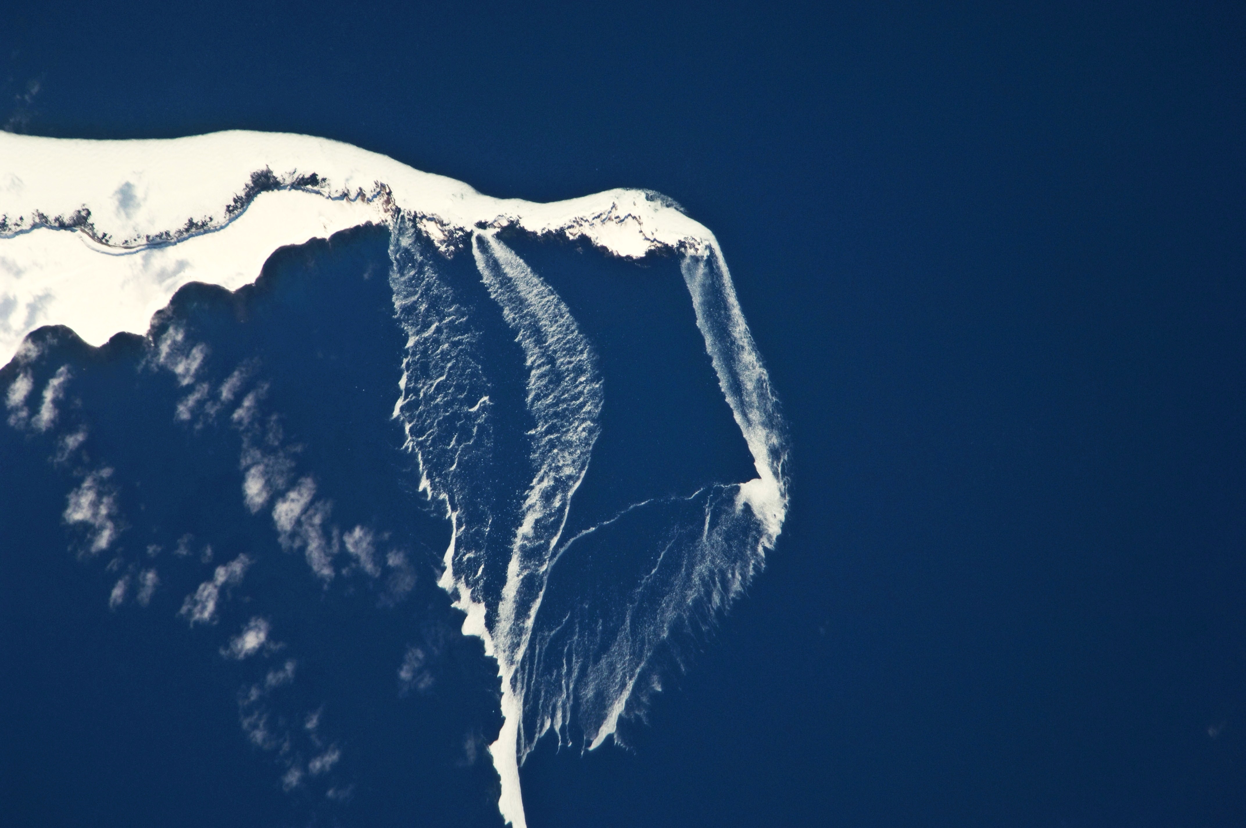
İzahIce Floes off the Northeastern Tip of Urup Island, Russia.jpg
English: The north-eastern tip of the island and three small islands to the north-east are recognizable by their uniform cover of white snow and shadowing along the north-western coastlines. Sea ice that formed to the north in the Sea of Okhotsk has been piled up against the islands by prevailing north-westerly winds, forming an irregular mass connecting the islands (image centre). The orientation of patchy low clouds over Urup Island (image lower left) also suggests that north-westerly winds are present. Smaller ice floes are breaking off from the main ice mass at gaps between the islands and forming finger-like projections of ice fragments that extend to the south-east (image lower right). Surface winds may be channelled through these gaps and accelerated, hastening the breakup and movement of ice.
Tarix
Mənbə
NASA Earth Observatory
Müəllif
Image captured by the NASA Expedition 23 crew
Image acquired with a Nikon D2Xs digital camera fitted with an 800 mm lens, and is provided by the ISS Crew Earth Observations experiment and Image Science & Analysis Laboratory, Johnson Space Center. Center Point Latitude: 46.2 Center Point Longitude: 150.6 (Negative numbers indicate south for latitude and west for longitude). Camera Tilt: 13 Camera Focal Length: 800mm Camera: N2: Nikon D2Xs Film: 4288E : 4288 x 2848 pixel CMOS sensor, RGBG imager color filter. Nadir Point Latitude: 46.4, Longitude: 151.3 (Negative numbers indicate south for latitude and west for longitude) Nadir to Photo Center Direction: West Sun Azimuth: 127 (Clockwise angle in degrees from north to the sun measured at the nadir point) Spacecraft Altitude: 183 nautical miles (339 km) Sun Elevation Angle: 35 (Angle in degrees between the horizon and the sun, measured at the nadir point).
Lisenziya
Public domainPublic domainfalsefalse
Annotations
InfoField
This image is annotated: View the annotations at Commons
214
906
177
145
4288
2848
Urup Island
590
520
166
59
4288
2848
Sea ice
3323
97
761
424
4288
2848
Sea of Okhotsk
2567
1502
80
102
4288
2848
Sea ice
1458
772
80
48
4288
2848
island
1662
778
70
54
4288
2848
island
2090
772
102
48
4288
2848
island
Captions
Add a one-line explanation of what this file represents
Items portrayed in this file
təsvir edir
yaranma tarixi
19 aprel 2010
captured with ingilis
Nikon D2Xs ingilis
Faylın tarixçəsi
Faylın əvvəlki versiyasını görmək üçün gün/tarix bölməsindəki tarixlərə klikləyin.
{{Information |Description={{en|1=The north-eastern tip of the island and three small islands to the north-east are recognizable by their uniform cover of white snow and shadowing along the north-western coastlines. [[:C
Bu faylda fotoaparat və ya skanerlə əlavə olunmuş məlumatlar var. Əgər fayl sonradan redaktə olunubsa, bəzi parametrlər bu şəkildə göstərilənlərdən fərqli ola bilər.
Şəkil başlığı
090 101ND2XS 254
Kamera istehsalçısı
NIKON CORPORATION
Kamera modeli
NIKON D2Xs
Exposure time
1/1.250 saniyə (0,0008)
F nömrəsi
f/5,6
ISO sürət reytinqi
200
Orijinal tarix və vaxt
23:13, 30 mart 2010
Fokus məsafəsi
800 mm
Orientasiya
Normal
Üfüqi xətt
300 dpi
Şaquli xətt
300 dpi
Proqram təminatı
Microsoft Windows Photo Gallery 6.0.6001.18000
Faylın dəyişməsi tarixi və vaxtı
13:17, 19 aprel 2010
Ekspozisiya proqramı
Açıqlıq üstünlüyü
Exif versiyası
2.21
Tarix və vaxt rəqəmləşdirilir
23:13, 30 mart 2010
APEX shutter speed
10,287712
Obyektiv gözü
4,970854
APEX exposure bias
0
Maximum land aperture
5 APEX (f/5,66)
Metering mode
Dizaynlı
İşıq mənbəsi
Naməlum
Flaş
Flaş yandırılmadı
DateTime subseconds
90
DateTimeOriginal subseconds
90
DateTimeDigitized subseconds
90
Sensing method
Birkristallı matrisli rəngli sensor
Custom image processing
Normal proses
Exposure mode
Avtomatik ekspozisiya
Ağ balansı
Bəyaz balansın avtomatik tənzimlənməsi
Digital zoom ratio
1
Focal length in 35 mm film
1.200 mm
Scene capture type
Standart
Kontrast
Yumşaq
Doymuşluq
Normal
Kəskinlik
Normal
Subject distance range
Naməlum
Unique image ID
B349D1930306459A9D44085AE8322172
Yanvar 09, 2023
fayl, floes, northeastern, urup, island, russia, fayl, faylın, tarixçəsi, istifadə, edilən, səhifələr, faylın, qlobal, istifadəsi, metaməlumatlarsınaq, göstərişi, ölçüsü, piksel, digər, ölçülər, piksel, piksel, piksel, piksel, piksel, piksel, faylın, orijinalı. Fayl Faylin tarixcesi Istifade edilen sehifeler Faylin qlobal istifadesi MetamelumatlarSinaq gosterisi olcusu 800 531 piksel Diger olculer 320 213 piksel 640 425 piksel 1 024 680 piksel 1 280 850 piksel 2 560 1 700 piksel 4 288 2 848 piksel Faylin orijinali 8206 4 288 2 848 piksel fayl hecmi 3 03 MB MIME novu image jpeg Bu fayl Vikimedia Commons dadirve diger layihelerde istifade edile biler Faylin tesvir sehifesine get Xulase IzahIce Floes off the Northeastern Tip of Urup Island Russia jpg English The north eastern tip of the island and three small islands to the north east are recognizable by their uniform cover of white snow and shadowing along the north western coastlines Sea ice that formed to the north in the Sea of Okhotsk has been piled up against the islands by prevailing north westerly winds forming an irregular mass connecting the islands image centre The orientation of patchy low clouds over Urup Island image lower left also suggests that north westerly winds are present Smaller ice floes are breaking off from the main ice mass at gaps between the islands and forming finger like projections of ice fragments that extend to the south east image lower right Surface winds may be channelled through these gaps and accelerated hastening the breakup and movement of ice Tarix 19 aprel 2010Menbe NASA Earth ObservatoryMuellif Image captured by the NASA Expedition 23 crew Image acquired with a Nikon D2Xs digital camera fitted with an 800 mm lens and is provided by the ISS Crew Earth Observations experiment and Image Science amp Analysis Laboratory Johnson Space Center Center Point Latitude 46 2 Center Point Longitude 150 6 Negative numbers indicate south for latitude and west for longitude Camera Tilt 13 Camera Focal Length 800mm Camera N2 Nikon D2Xs Film 4288E 4288 x 2848 pixel CMOS sensor RGBG imager color filter Nadir Point Latitude 46 4 Longitude 151 3 Negative numbers indicate south for latitude and west for longitude Nadir to Photo Center Direction West Sun Azimuth 127 Clockwise angle in degrees from north to the sun measured at the nadir point Spacecraft Altitude 183 nautical miles 339 km Sun Elevation Angle 35 Angle in degrees between the horizon and the sun measured at the nadir point Lisenziya Public domain Public domain false falseThis file is in the public domain in the United States because it was solely created by NASA NASA copyright policy states that NASA material is not protected by copyright unless noted See Template PD USGov NASA copyright policy page or JPL Image Use Policy Warnings Use of NASA logos insignia and emblems is restricted per U S law 14 CFR 1221 The NASA website hosts a large number of images from the Soviet Russian space agency and other non American space agencies These are not necessarily in the public domain Materials based on Hubble Space Telescope data may be copyrighted if they are not explicitly produced by the STScI 1 See also PD Hubble and Cc Hubble The SOHO ESA amp NASA joint project implies that all materials created by its probe are copyrighted and require permission for commercial non educational use 2 Images featured on the Astronomy Picture of the Day APOD web site may be copyrighted 3 The National Space Science Data Center NSSDC site has been known to host copyrighted content Its photo gallery FAQ states that all of the images in the photo gallery are in the public domain Unless otherwise noted AnnotationsInfoFieldThis image is annotated View the annotations at Commons214 906 177 145 4288 2848 Urup Island 590 520 166 59 4288 2848 Sea ice 3323 97 761 424 4288 2848 Sea of Okhotsk 2567 1502 80 102 4288 2848 Sea ice 1458 772 80 48 4288 2848 island 1662 778 70 54 4288 2848 island 2090 772 102 48 4288 2848 islandCaptionsazerbaycancaAdd a one line explanation of what this file representsItems portrayed in this filetesvir ediryaranma tarixi19 aprel 2010captured with ingilisNikon D2Xs ingilis Faylin tarixcesi Faylin evvelki versiyasini gormek ucun gun tarix bolmesindeki tarixlere klikleyin Tarix VaxtKicik sekilOlculerIstifadeciSerh indiki12 36 19 aprel 20104 288 2 848 3 03 MB Originalwana Information Description en 1 The north eastern tip of the island and three small islands to the north east are recognizable by their uniform cover of white snow and shadowing along the north western coastlines C Istifade edilen sehifeler Bu sekile olan kecidler Urup Faylin qlobal istifadesi Bu fayl asagidaki vikilerde istifade olunur bg wikipedia org layihesinde istifadesi Urup en wikipedia org layihesinde istifadesi Urup gl wikipedia org layihesinde istifadesi Urup it wikipedia org layihesinde istifadesi Isole Taira ru wikipedia org layihesinde istifadesi UrupMetamelumatlar Bu faylda fotoaparat ve ya skanerle elave olunmus melumatlar var Eger fayl sonradan redakte olunubsa bezi parametrler bu sekilde gosterilenlerden ferqli ola biler Sekil basligi090 101ND2XS 254Kamera istehsalcisiNIKON CORPORATIONKamera modeliNIKON D2XsExposure time1 1 250 saniye 0 0008 F nomresif 5 6ISO suret reytinqi200Orijinal tarix ve vaxt23 13 30 mart 2010Fokus mesafesi800 mmOrientasiyaNormalUfuqi xett300 dpiSaquli xett300 dpiProqram teminatiMicrosoft Windows Photo Gallery 6 0 6001 18000Faylin deyismesi tarixi ve vaxti13 17 19 aprel 2010Ekspozisiya proqramiAciqliq ustunluyuExif versiyasi2 21Tarix ve vaxt reqemlesdirilir23 13 30 mart 2010APEX shutter speed10 287712Obyektiv gozu4 970854APEX exposure bias0Maximum land aperture5 APEX f 5 66 Metering modeDizaynliIsiq menbesiNamelumFlasFlas yandirilmadiDateTime subseconds90DateTimeOriginal subseconds90DateTimeDigitized subseconds90Sensing methodBirkristalli matrisli rengli sensorCustom image processingNormal prosesExposure modeAvtomatik ekspozisiyaAg balansiBeyaz balansin avtomatik tenzimlenmesiDigital zoom ratio1Focal length in 35 mm film1 200 mmScene capture typeStandartKontrastYumsaqDoymusluqNormalKeskinlikNormalSubject distance rangeNamelumUnique image IDB349D1930306459A9D44085AE8322172 Menbe https az wikipedia org wiki Fayl Ice Floes off the Northeastern Tip of Urup Island Russia jpg, wikipedia, oxu, kitab, kitabxana, axtar, tap, hersey,
ne axtarsan burda
, en yaxsi meqale sayti, meqaleler, kitablar, oyrenmek, wiki, bilgi, tarix, seks, porno, indir, yukle, sex, azeri sex, azeri, seks yukle, sex yukle, izle, seks izle, porno izle, mobil seks, telefon ucun, chat, azeri chat, tanisliq, tanishliq, azeri tanishliq, sayt, medeni, medeni saytlar, chatlar, mekan, tanisliq mekani, mekanlari, yüklə, pulsuz, pulsuz yüklə, mp3, video, mp4, 3gp, jpg, jpeg, gif, png, şəkil, muisiqi, mahnı, kino, film, kitab, oyun, oyunlar.