Bu fayl "Vikimedia Commons"dadır və digər layihələrdə istifadə edilə bilər.
Faylın təsvir səhifəsinə get
Xülasə
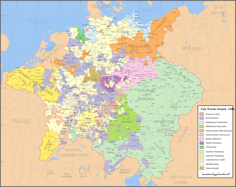
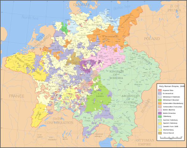
İzahHoly Roman Empire 1648.svg
English: Map of the Holy Roman Empire in 1648, after the Peace of Westphalia which ended the Thirty Years' War.
Deutsch: Karte des Heiligen Römischen Reiches 1648, nach dem Westfälischer Friede, der den Dreißigjähriger Krieg beendete.
Français : Carte du Saint-Empire à 1648, après la paix de Westphalie qui mettent fin à la guerre de Trente Ans. Version française est disponible à File:Holy Roman Empire 1648 fr.svg.
Српски / srpski: Мапа Светог римског царства у 1648, након Вестфалског мира којим је завршен Тридесетогодишњи рат.
Abbreviations
/
Abkürzungen
/
Abréviations
/
Скраћенице
English
Deutsch
Français
Српски
A
Archbishopric
Erzbistum
Archevêché
АДИЈ.
Архидијецеза
B
Bishopric
Bistum
Évêché
ДИЈ.
Дијецеза
C
County
Grafschaft
Comté
ОКР./ГРОФ.
Округ/грофовија
D
Duchy
Herzogtum
Duché
ВОЈВ.
Војводство
E
Electorate
Kurfürstentum
Électorat
ЕЛЕКТ.
Електорат
L
Landgraviate
Landgrafschaft
Landgraviat
ЛГРОФ.
Ландгрофовија
M
Margraviate
Markgrafschaft
Margraviat
МГРОФ.
Маркгрофовија
P
Principality
Fürstentum
Principauté
ГРОФ./ОКР.
Грофовија/округ
Legend
/
Farblegende
/
Légende
/
Легенда
English
Deutsch
Français
Српски
Imperial cities
Reichsstädte
Villes libres d'Empire
Царски градови
Ecclesiastical lands
Geistliche Territorien
Pays ecclésiastiques
Еклесијастикални
Wittelsbach Palatinate
Wittelsbacher Pfalzgrafschaft bei Rhein
Palatinat des Wittelsbach
Вителсбах, палатинатски
Wittelsbach Bavaria
Wittelsbacher Bayern
Bavière des Wittelsbach
Вителсбах, баварски
Hohenzollern Brandenburg
Hohenzollerner Brandenburg
Brandebourg des Hohenzollern
Хоенцолерн, бранденбуршки
Hohenzollern Franconia
Hohenzollerner Franken
Franconie des Hohenzollern
Хоенцолерн, франконски
Wettin Albertine Saxony
Wettiner Albertiner Sachsen
Saxe de la branche albertine des Wettin
Ветин, албертински
Wettin Ernestine Saxony
Wettiner Ernestiner Sachsen
Saxe de la branche ernestine des Wettin
Ветин, ернестински
County of Oldenburg
Grafschaft Oldenburg
Comté d'Oldenbourg
Олденбург
Habsburg Austria
Habsburger Österreich
Autriche des Habsbourg
Хабзбург, аустријски
Habsburg Netherlands
Habsburger Niederlande
Pays-Bas des Habsbourg
Хабзбург, шпански
Swedish duchies
Schwedischen Herzogtümern
Duchés suédois
Шведска
Duchy of Württemberg
Herzogtum Württemberg
Duché de Wurtemberg
Виртемберг
Landgraviate of Hesse-Kassel
Landgrafschaft Hessen-Kassel
Landgraviat de Hesse-Cassel
Хесе-Касел
Editing guide
InfoField
Made in Inkscape. Each of the parts to the map are saved on a separate layer, so that they can be edited/moved/hidden separately when it is opened in Inkscape. All the regions such as imperial cities, ecclesiastical lands, etc. are grouped together so that the colours can be changed easily if necessary. Uses the colour scheme of WikiProject Maps and the free to use Color Brewer.
Tarix
Mənbə
Made from the public domain map "Central Europe about 1648" from the Historical Atlas by William R. Shepherd, at the Perry-Castañeda Library Map Collection at the University of Texas. Further information from Overy, Richard, 2006, The Times Complete history of the world Times Books ISBN 0007181299, and from this map
See also other maps at external links:
Central Europe 1648
Map on personal site, Europe in 1648
Treaty of Westphalia
1648 map of Prussia
Britannica, Spanish domains in 1648
This W3C-unspecified vector image was created with Inkscape .
Müəllif
Astrokey44
İcazə (Faylın təkrar istifadəsi)
Bu sənədi GNU Azad Sənədləşdirmə Lisenziyası, Versiya 1.2 və ya Azad Proqram Fondu tərəfindən nəşr olunan hər hansı sonrakı versiya şərtlərinə əsasən dəyişməz bölmələr, ön qapaq mətnləri və arxa qapaq mətnləri olmadan köçürmək, yayımlamaq və / və ya dəyişdirmək üçün icazə verilir; Lisenziyanın bir nüsxəsi GNU Azad Sənədləşdirmə Lisenziyası adlı hissəyə daxil edilmişdir.http://www.gnu.org/copyleft/fdl.htmlGFDLGNU Free Documentation Licensetruetrue
Bu fayl Creative Commons Attribution-Share Alike 3.0 Sinqapur lisenziyası altında yayımlanır.
Azadsınız:
paylaşmaq – əsəri köçürmək, paylamaq və ötürmək üçün
remiks etmək – əsəri adaptasiya etmək
Aşağıdakı şərtlərə riayət etməklə:
istinad – Müvafiq kredit verməlisiniz, lisenziyaya bir keçid verməlisiniz və dəyişikliklərin olub olmadığını bildirməlisiniz. Bunu hər hansı bir ağlabatan şəkildə edə bilərsiniz, ancaq lisenziyalaşdırıcının sizi və ya istifadənizi təsdiqləməsini təklif edən bir şəkildə deyil.
bənzər paylaşma – Əsəri remix edirsinizsə, dəyişdirirsinizsə və ya üzərində iş aparırsınızsa, öz töhfələrinizi orijinalda olduğu kimi eyni və ya uyğun lisenziya altında yayımlamalısınız.
This licensing tag was added to this file as part of the GFDL licensing update.http://creativecommons.org/licenses/by-sa/3.0/CC-BY-SA-3.0Creative Commons Attribution-Share Alike 3.0truetrue
Digər versiyalar
[redaktə]
ingilis SVG
ispan SVG
fransız SVG
gürcü SVG
serb SVG
English: Blank PNG
ingilis PNG
ispan PNG
serb PNG
rus PNG
This SVG file contains embedded text that can be translated into your language, using any capable SVG editor, text editor or the SVG Translate tool. For more information see: About translating SVG files.
Captions
Add a one-line explanation of what this file represents
Cleanup some names including missing umlauts. Brunswick-Lüneburg -> Brunswick-Celle (see talk). Border north of Rendsburg seems slightly off to me and the situation in Holstein is rather simplified (jointly administered areas are missing).
Bu faylda fotoaparat və ya skanerlə əlavə olunmuş məlumatlar var. Əgər fayl sonradan redaktə olunubsa, bəzi parametrlər bu şəkildə göstərilənlərdən fərqli ola bilər.
Genişlik
2283
Hündürlük
1810
Yanvar 03, 2023
fayl, holy, roman, empire, 1648, fayl, faylın, tarixçəsi, istifadə, edilən, səhifələr, faylın, qlobal, istifadəsi, metaməlumatlarbu, faylın, formatındakı, görünüşünün, ölçüsü, piksel, digər, ölçülər, piksel, piksel, piksel, piksel, piksel, piksel, faylın, orij. Fayl Faylin tarixcesi Istifade edilen sehifeler Faylin qlobal istifadesi MetamelumatlarBu SVG faylin PNG formatindaki bu gorunusunun olcusu 756 599 piksel Diger olculer 303 240 piksel 606 480 piksel 969 768 piksel 1 280 1 015 piksel 2 560 2 030 piksel 2 283 1 810 piksel Faylin orijinali 8206 SVG fayli nominal olaraq 2 283 1 810 piksel faylin olcusu 3 07 MB Bu fayl Vikimedia Commons dadirve diger layihelerde istifade edile biler Faylin tesvir sehifesine get Xulase IzahHoly Roman Empire 1648 svg English Map of the Holy Roman Empire in 1648 after the Peace of Westphalia which ended the Thirty Years War Deutsch Karte des Heiligen Romischen Reiches 1648 nach dem Westfalischer Friede der den Dreissigjahriger Krieg beendete Francais Carte du Saint Empire a 1648 apres la paix de Westphalie qui mettent fin a la guerre de Trente Ans Version francaise est disponible a File Holy Roman Empire 1648 fr svg Srpski srpski Mapa Svetog rimskog carstva u 1648 nakon Vestfalskog mira koјim јe zavrshen Tridesetogodishњi rat Abbreviations Abkurzungen Abreviations Skraћenice EnglishDeutschFrancaisSrpskiAArchbishopricErzbistumArchevecheADIЈ ArhidiјecezaBBishopricBistumEvecheDIЈ DiјecezaCCountyGrafschaftComteOKR GROF Okrug grofoviјaDDuchyHerzogtumDucheVOЈV VoјvodstvoEElectorateKurfurstentumElectoratELEKT ElektoratLLandgraviateLandgrafschaftLandgraviatLGROF LandgrofoviјaMMargraviateMarkgrafschaftMargraviatMGROF MarkgrofoviјaPPrincipalityFurstentumPrincipauteGROF OKR Grofoviјa okrugLegend Farblegende Legende Legenda EnglishDeutschFrancaisSrpski Imperial cities Reichsstadte Villes libres d Empire Carski gradovi Ecclesiastical lands Geistliche Territorien Pays ecclesiastiques Eklesiјastikalni Wittelsbach Palatinate Wittelsbacher Pfalzgrafschaft bei Rhein Palatinat des Wittelsbach Vitelsbah palatinatski Wittelsbach Bavaria Wittelsbacher Bayern Baviere des Wittelsbach Vitelsbah bavarski Hohenzollern Brandenburg Hohenzollerner Brandenburg Brandebourg des Hohenzollern Hoencolern brandenburshki Hohenzollern Franconia Hohenzollerner Franken Franconie des Hohenzollern Hoencolern frankonski Wettin Albertine Saxony Wettiner Albertiner Sachsen Saxe de la branche albertine des Wettin Vetin albertinski Wettin Ernestine Saxony Wettiner Ernestiner Sachsen Saxe de la branche ernestine des Wettin Vetin ernestinski County of Oldenburg Grafschaft Oldenburg Comte d Oldenbourg Oldenburg Habsburg Austria Habsburger Osterreich Autriche des Habsbourg Habzburg austriјski Habsburg Netherlands Habsburger Niederlande Pays Bas des Habsbourg Habzburg shpanski Swedish duchies Schwedischen Herzogtumern Duches suedois Shvedska Duchy of Wurttemberg Herzogtum Wurttemberg Duche de Wurtemberg Virtemberg Landgraviate of Hesse Kassel Landgrafschaft Hessen Kassel Landgraviat de Hesse Cassel Hese KaselEditing guideInfoFieldMade in Inkscape Each of the parts to the map are saved on a separate layer so that they can be edited moved hidden separately when it is opened in Inkscape All the regions such as imperial cities ecclesiastical lands etc are grouped together so that the colours can be changed easily if necessary Uses the colour scheme of WikiProject Maps and the free to use Color Brewer Tarix 29 yanvar 2007Menbe Made from the public domain map Central Europe about 1648 from the Historical Atlas by William R Shepherd at the Perry Castaneda Library Map Collection at the University of Texas Further information from Overy Richard 2006 The Times Complete history of the world Times Books ISBN 0007181299 and from this mapSee also other maps at external links Central Europe 1648 Map on personal site Europe in 1648 Treaty of Westphalia 1648 map of Prussia Britannica Spanish domains in 1648 This W3C unspecified vector image was created with Inkscape Muellif Astrokey44Icaze Faylin tekrar istifadesi Bu senedi GNU Azad Senedlesdirme Lisenziyasi Versiya 1 2 ve ya Azad Proqram Fondu terefinden nesr olunan her hansi sonraki versiya sertlerine esasen deyismez bolmeler on qapaq metnleri ve arxa qapaq metnleri olmadan kocurmek yayimlamaq ve ve ya deyisdirmek ucun icaze verilir Lisenziyanin bir nusxesi GNU Azad Senedlesdirme Lisenziyasi adli hisseye daxil edilmisdir http www gnu org copyleft fdl html GFDL GNU Free Documentation License true trueBu fayl Creative Commons Attribution Share Alike 3 0 Sinqapur lisenziyasi altinda yayimlanir Azadsiniz paylasmaq eseri kocurmek paylamaq ve oturmek ucun remiks etmek eseri adaptasiya etmek Asagidaki sertlere riayet etmekle istinad Muvafiq kredit vermelisiniz lisenziyaya bir kecid vermelisiniz ve deyisikliklerin olub olmadigini bildirmelisiniz Bunu her hansi bir aglabatan sekilde ede bilersiniz ancaq lisenziyalasdiricinin sizi ve ya istifadenizi tesdiqlemesini teklif eden bir sekilde deyil benzer paylasma Eseri remix edirsinizse deyisdirirsinizse ve ya uzerinde is aparirsinizsa oz tohfelerinizi orijinalda oldugu kimi eyni ve ya uygun lisenziya altinda yayimlamalisiniz This licensing tag was added to this file as part of the GFDL licensing update http creativecommons org licenses by sa 3 0 CC BY SA 3 0 Creative Commons Attribution Share Alike 3 0 true trueDiger versiyalar redakte ingilis SVG ispan SVG fransiz SVG gurcu SVG serb SVG English Blank PNG ingilis PNG ispan PNG serb PNG rus PNG This SVG file contains embedded text that can be translated into your language using any capable SVG editor text editor or the SVG Translate tool For more information see About translating SVG files CaptionsazerbaycancaAdd a one line explanation of what this file representsItems portrayed in this filetesvir ediryaradiciSome value without a Vikiverilenler itemWikimedia username ingilis Astrokey44muellifin qisa adi Astrokey44URL ingilis https commons wikimedia org wiki user Astrokey44copyright status ingiliscopyrighted ingilislisenziyaGNU Free Documentation License version 1 2 or later ingilisCreative Commons Attribution ShareAlike 3 0 Unported ingilisyaranma tarixi29 yanvar 2007MIME type ingilisimage svg xml Faylin tarixcesi Faylin evvelki versiyasini gormek ucun gun tarix bolmesindeki tarixlere klikleyin en yeni en evvelki Goster 10 daha yeni 10 daha kohne 10 20 50 100 250 500 Tarix VaxtKicik sekilOlculerIstifadeciSerh indiki20 43 24 iyul 20222 283 1 810 3 07 MB MaproomZWEIBRCKEN gt ZWEIBRUCKEN Treves gt Trier Liege gt Liege 17 55 18 may 20222 283 1 810 3 07 MB MaproomConsistent and German spelling of Mainz 20 11 25 may 20212 283 1 810 3 07 MB ElCetadded the biggest city of Upper Silesia back then 11 34 23 mart 20182 283 1 810 3 01 MB ValentinianCleanup some names including missing umlauts Brunswick Luneburg gt Brunswick Celle see talk Border north of Rendsburg seems slightly off to me and the situation in Holstein is rather simplified jointly administered areas are missing 19 09 8 oktyabr 20102 283 1 810 3 01 MB JoostikRavenstein as part of Cleves 19 45 9 avqust 20092 283 1 810 3 01 MB Ysangkoksimplify code save as plain svg 09 24 14 iyul 20092 283 1 810 4 17 MB Roke commonswikiZusmarshausen 15 16 20 aprel 20072 283 1 810 4 12 MB Roke commonswiki 02 04 20 aprel 20072 283 1 810 4 11 MB Roke commonswikirm HRE text darken labels 03 04 18 aprel 20072 283 1 810 4 11 MB Roke commonswiki en yeni en evvelki Goster 10 daha yeni 10 daha kohne 10 20 50 100 250 500 Istifade edilen sehifeler Bu sekile olan kecidler Vestfaliya sulhu Faylin qlobal istifadesi Bu fayl asagidaki vikilerde istifade olunur af wikipedia org layihesinde istifadesi Duitsland azb wikipedia org layihesinde istifadesi آلمانلار موقدس روم ژرمن ایمپراتورلوغو اوتوز ایللیک ساواش وستفالی باریش br wikipedia org layihesinde istifadesi Feur emglev Westfalen ca wikipedia org layihesinde istifadesi Electorat del Palatinat ckb wikipedia org layihesinde istifadesi شەڕی سی ساڵە cs wikipedia org layihesinde istifadesi Vestfalsky mir de wikipedia org layihesinde istifadesi Geschichte Wiens el wikipedia org layihesinde istifadesi Triakontaeths Polemos en wikipedia org layihesinde istifadesi Peace of Westphalia Thirty Years War Germans Wikipedia WikiProject Maps Imperial Estate Talk Paul Skalich Treaty of Fontainebleau 1631 Wikipedia Featured picture candidates Holy Roman Empire in 1648 Wikipedia Featured picture candidates May 2007 User talk Giano II archive 7 User Luosiji Sandbox User Jammydodger HRE Germany in the early modern period User Zealotzuo Sandbox Wikipedia talk WikiProject Maps Archive 5 Territorial evolution of France User Oaholroyd sandbox User DyinRich Something Else Aftermath of the Eighty Years War eo wikipedia org layihesinde istifadesi Tridekjara Milito et wikipedia org layihesinde istifadesi Anhalt Riigiseisus fa wikipedia org layihesinde istifadesi پیمان وستفالی ایالات امپراتوری fi wikipedia org layihesinde istifadesi Westfalenin rauha fy wikipedia org layihesinde istifadesi Ryksstannen hu wikipedia org layihesinde istifadesi I Lipot magyar kiraly Harminceves haboru Uralkodok listai foldrajzi elhelyezkedes szerint Becs ostroma 1683 hy wikipedia org layihesinde istifadesi Կաղապար Տեղեկաքարտ Պատմական երկիր Սրբազան Հռոմեական կայսրություն Կաղապար Տեղեկաքարտ Պատմական երկիր doc id wikipedia org layihesinde istifadesi Perdamaian Westfalen Wikipedia ProyekWiki Peta it wikipedia org layihesinde istifadesi Storia della Germania Pace di Vestfalia Trento Guerra dei trent anni Bu faylin qlobal istifadesine baxin Metamelumatlar Bu faylda fotoaparat ve ya skanerle elave olunmus melumatlar var Eger fayl sonradan redakte olunubsa bezi parametrler bu sekilde gosterilenlerden ferqli ola biler Genislik2283Hundurluk1810 Menbe https az wikipedia org wiki Fayl Holy Roman Empire 1648 svg, wikipedia, oxu, kitab, kitabxana, axtar, tap, hersey,
ne axtarsan burda
, en yaxsi meqale sayti, meqaleler, kitablar, oyrenmek, wiki, bilgi, tarix, seks, porno, indir, yukle, sex, azeri sex, azeri, seks yukle, sex yukle, izle, seks izle, porno izle, mobil seks, telefon ucun, chat, azeri chat, tanisliq, tanishliq, azeri tanishliq, sayt, medeni, medeni saytlar, chatlar, mekan, tanisliq mekani, mekanlari, yüklə, pulsuz, pulsuz yüklə, mp3, video, mp4, 3gp, jpg, jpeg, gif, png, şəkil, muisiqi, mahnı, kino, film, kitab, oyun, oyunlar.