Bu fayl "Vikimedia Commons"dadır və digər layihələrdə istifadə edilə bilər.
Faylın təsvir səhifəsinə get
Xülasə
İzahGwadar satellite view showing island created by 2013 earthquake.jpg
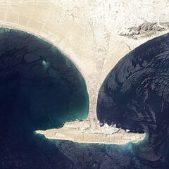
English: Zalzala Jazeera (Earthquake Island) appears in the upper left quadrant of this image of Gwadar, Pakistan.
On September 26, 2013, the Advanced Land Imager (ALI) on NASA’s Earth Observing-1 (EO-1) satellite captured the top image of that new island, which sits roughly one kilometer (0.6 miles) offshore. Likely a “mud volcano,” the island rose from the seafloor near Gwadar on September 24, shortly after the earthquake struck about 380 kilometers (230 miles) inland. File:Gwadar satellite view.jpg, acquired by the Operational Land Imager on the Landsat 8 satellite, shows the same area on April 17, 2013.
In the satellite images, lighter shades of green and tan in the water reveal shallow seafloor or suspended sediment. The water depth around the new island is roughly 15 to 20 meters, according to marine geologist Asif Inam of Pakistan’s National Institute of Oceanography. “The floor in that area is generally flat, but the gradient in this area changes quite abruptly,” Inam said. The top image from ALI is also clear enough to show the parallel ripples of waves marching toward the shore.
Bu faylda fotoaparat və ya skanerlə əlavə olunmuş məlumatlar var. Əgər fayl sonradan redaktə olunubsa, bəzi parametrlər bu şəkildə göstərilənlərdən fərqli ola bilər.
Şəkil başlığı
IDL TIFF file
Genişlik
5.941 px
Hündürlük
10.831 px
Bits per component
16
16
16
Sıxılmamış
LZW
Rəng modeli
RGB
Orientasiya
Normal
Rəng komponentlərinin sayı
3
Üfüqi xətt
100 dpi
Şaquli xətt
100 dpi
Data arrangement
chunky format
Proqram təminatı
Adobe Photoshop CS6 (Macintosh)
Faylın dəyişməsi tarixi və vaxtı
10:19, 27 sentyabr 2013
Rəng sahəsi
Fotoşəkildə rəng seçimi edilməmişdir.
Tarix və vaxt rəqəmləşdirilir
11:17, 26 sentyabr 2013
Date metadata was last modified
06:19, 27 sentyabr 2013
Unique ID of original document
xmp.did:92DB18B2782068118C14B8A75F09C7C4
Fevral 06, 2023
fayl, gwadar, satellite, view, showing, island, created, 2013, earthquake, fayl, faylın, tarixçəsi, istifadə, edilən, səhifələr, faylın, qlobal, istifadəsi, metaməlumatlarsınaq, göstərişi, ölçüsü, piksel, digər, ölçülər, piksel, piksel, piksel, piksel, piksel,. Fayl Faylin tarixcesi Istifade edilen sehifeler Faylin qlobal istifadesi MetamelumatlarSinaq gosterisi olcusu 600 600 piksel Diger olculer 240 240 piksel 480 480 piksel 768 768 piksel 1 024 1 024 piksel 2 000 2 000 piksel Faylin orijinali 8206 2 000 2 000 piksel fayl hecmi 861 KB MIME novu image jpeg Bu fayl Vikimedia Commons dadirve diger layihelerde istifade edile biler Faylin tesvir sehifesine get Xulase IzahGwadar satellite view showing island created by 2013 earthquake jpg English Zalzala Jazeera Earthquake Island appears in the upper left quadrant of this image of Gwadar Pakistan On September 26 2013 the Advanced Land Imager ALI on NASA s Earth Observing 1 EO 1 satellite captured the top image of that new island which sits roughly one kilometer 0 6 miles offshore Likely a mud volcano the island rose from the seafloor near Gwadar on September 24 shortly after the earthquake struck about 380 kilometers 230 miles inland File Gwadar satellite view jpg acquired by the Operational Land Imager on the Landsat 8 satellite shows the same area on April 17 2013 In the satellite images lighter shades of green and tan in the water reveal shallow seafloor or suspended sediment The water depth around the new island is roughly 15 to 20 meters according to marine geologist Asif Inam of Pakistan s National Institute of Oceanography The floor in that area is generally flat but the gradient in this area changes quite abruptly Inam said The top image from ALI is also clear enough to show the parallel ripples of waves marching toward the shore Tarix 26 sentyabr 2013 11 17 39Menbe http earthobservatory nasa gov NaturalHazards view php id 82146Muellif NASADiger versiyalar Camera location25 12 00 N 62 12 00 E View this and other nearby images on OpenStreetMap25 200000 62 200000Lisenziya Public domain Public domain false falseThis file is in the public domain in the United States because it was solely created by NASA NASA copyright policy states that NASA material is not protected by copyright unless noted See Template PD USGov NASA copyright policy page or JPL Image Use Policy Warnings Use of NASA logos insignia and emblems is restricted per U S law 14 CFR 1221 The NASA website hosts a large number of images from the Soviet Russian space agency and other non American space agencies These are not necessarily in the public domain Materials based on Hubble Space Telescope data may be copyrighted if they are not explicitly produced by the STScI 1 See also PD Hubble and Cc Hubble The SOHO ESA amp NASA joint project implies that all materials created by its probe are copyrighted and require permission for commercial non educational use 2 Images featured on the Astronomy Picture of the Day APOD web site may be copyrighted 3 The National Space Science Data Center NSSDC site has been known to host copyrighted content Its photo gallery FAQ states that all of the images in the photo gallery are in the public domain Unless otherwise noted CaptionsazerbaycancaAdd a one line explanation of what this file representsItems portrayed in this filetesvir ediryaranma tarixi26 sentyabr 2013coordinates of the point of view ingilis25 12 N 62 12 E Faylin tarixcesi Faylin evvelki versiyasini gormek ucun gun tarix bolmesindeki tarixlere klikleyin Tarix VaxtKicik sekilOlculerIstifadeciSerh indiki01 04 28 sentyabr 20132 000 2 000 861 KB Ke4rohUser created page with UploadWizard Istifade edilen sehifeler Bu sekile olan kecidler Zelzele adasi Faylin qlobal istifadesi Bu fayl asagidaki vikilerde istifade olunur ar wikipedia org layihesinde istifadesi جزيرة زلزلة de wikipedia org layihesinde istifadesi Gwadar es wikipedia org layihesinde istifadesi Isla Zalzala fi wikipedia org layihesinde istifadesi Gwadar fr wikipedia org layihesinde istifadesi Zalzala Koh it wikipedia org layihesinde istifadesi Isola Terremoto ru wikipedia org layihesinde istifadesi Zalzala sd wikipedia org layihesinde istifadesi زلزلو ٻيٽ tr wikipedia org layihesinde istifadesi Zelzele AdasiMetamelumatlar Bu faylda fotoaparat ve ya skanerle elave olunmus melumatlar var Eger fayl sonradan redakte olunubsa bezi parametrler bu sekilde gosterilenlerden ferqli ola biler Sekil basligiIDL TIFF fileGenislik5 941 pxHundurluk10 831 pxBits per component16 16 16SixilmamisLZWReng modeliRGBOrientasiyaNormalReng komponentlerinin sayi3Ufuqi xett100 dpiSaquli xett100 dpiData arrangementchunky formatProqram teminatiAdobe Photoshop CS6 Macintosh Faylin deyismesi tarixi ve vaxti10 19 27 sentyabr 2013Reng sahesiFotosekilde reng secimi edilmemisdir Tarix ve vaxt reqemlesdirilir11 17 26 sentyabr 2013Date metadata was last modified06 19 27 sentyabr 2013Unique ID of original documentxmp did 92DB18B2782068118C14B8A75F09C7C4 Menbe https az wikipedia org wiki Fayl Gwadar satellite view showing island created by 2013 earthquake jpg, wikipedia, oxu, kitab, kitabxana, axtar, tap, hersey,
ne axtarsan burda
, en yaxsi meqale sayti, meqaleler, kitablar, oyrenmek, wiki, bilgi, tarix, seks, porno, indir, yukle, sex, azeri sex, azeri, seks yukle, sex yukle, izle, seks izle, porno izle, mobil seks, telefon ucun, chat, azeri chat, tanisliq, tanishliq, azeri tanishliq, sayt, medeni, medeni saytlar, chatlar, mekan, tanisliq mekani, mekanlari, yüklə, pulsuz, pulsuz yüklə, mp3, video, mp4, 3gp, jpg, jpeg, gif, png, şəkil, muisiqi, mahnı, kino, film, kitab, oyun, oyunlar.