Bu fayl "Vikimedia Commons"dadır və digər layihələrdə istifadə edilə bilər.
Faylın təsvir səhifəsinə get
İzahGroundwater flow.svg
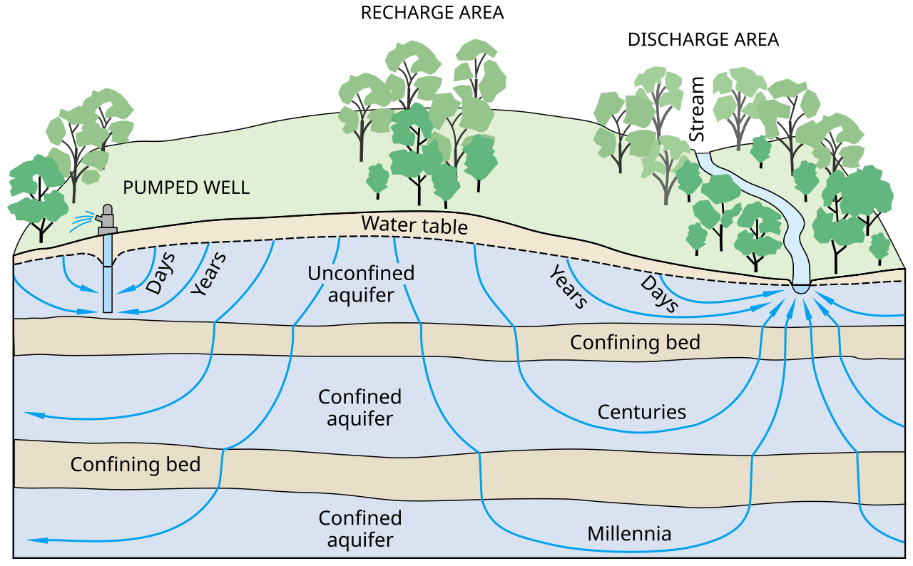
English: Ground-water flow paths vary greatly in length, depth, and traveltime from points of recharge to points of discharge in the groundwater system.
العربية: تدفق المياه السطحية ضمن المسارات يختلف بشكل كبير من حيث الطول و العمق و زمن المسير من نقطة الدخول لإالى نقطة الخروج في نظام المياه السطحية.
Tarix
Mənbə
Ground Water And Surface Water A Single Resource. U.S. Geological Survey Circular 1139, Figure 3.
Müəllif
T.C. Winter, J.W. Harvey, O.L. Franke, and W.M. Alley
SVG genesis
InfoField
The SVG code is valid.
This diagram was created with Inkscape, or with something else.
This diagram uses embedded text that can be easily translated using a text editor.
Lisenziya
Public domainPublic domainfalsefalse
Captions
Add a one-line explanation of what this file represents
Schematic of an aquifer showing confined zones, groundwater travel times, a spring and a well
Schema van een watervoerende laag met beperkte zones, reistijden van het grondwater, een bron en een put
Items portrayed in this file
təsvir edir
aquifer ingilis
yaranma tarixi
1998
Faylın tarixçəsi
Faylın əvvəlki versiyasını görmək üçün gün/tarix bölməsindəki tarixlərə klikləyin.
Technologies for Rural Development/Using water resources
تهیسازی منبع
भूजल
जलभर
it.wikibooks.org layihəsində istifadəsi
Scienze della Terra per le superiori/Le falde acquifere
it.wikiversity.org layihəsində istifadəsi
Il modellamento fluviale (superiori)
Википедия:К удалению/26 ноября 2021
Корисник:Grujović Milena/Resource depletion
Трошење ресурса
Metaməlumatlar
Bu faylda fotoaparat və ya skanerlə əlavə olunmuş məlumatlar var. Əgər fayl sonradan redaktə olunubsa, bəzi parametrlər bu şəkildə göstərilənlərdən fərqli ola bilər.
Qısa başlıq
Ground Water And Surface Water A Single Resource
Genişlik
645
Hündürlük
400
Fevral 10, 2023
fayl, groundwater, flow, fayl, faylın, tarixçəsi, fayl, keçidləri, faylın, qlobal, istifadəsi, metaməlumatlarbu, faylın, formatındakı, görünüşünün, ölçüsü, piksel, digər, ölçülər, piksel, piksel, piksel, piksel, piksel, faylın, orijinalı, 8206, faylı, nominal,. Fayl Faylin tarixcesi Fayl kecidleri Faylin qlobal istifadesi MetamelumatlarBu SVG faylin PNG formatindaki bu gorunusunun olcusu 645 400 piksel Diger olculer 320 198 piksel 640 397 piksel 1 024 635 piksel 1 280 794 piksel 2 560 1 588 piksel Faylin orijinali 8206 SVG fayli nominal olaraq 645 400 piksel faylin olcusu 86 KB Bu fayl Vikimedia Commons dadirve diger layihelerde istifade edile biler Faylin tesvir sehifesine get IzahGroundwater flow svg English Ground water flow paths vary greatly in length depth and traveltime from points of recharge to points of discharge in the groundwater system العربية تدفق المياه السطحية ضمن المسارات يختلف بشكل كبير من حيث الطول و العمق و زمن المسير من نقطة الدخول لإالى نقطة الخروج في نظام المياه السطحية Tarix 1998Menbe Ground Water And Surface Water A Single Resource U S Geological Survey Circular 1139 Figure 3 Muellif T C Winter J W Harvey O L Franke and W M AlleySVG genesisInfoField The SVG code is valid This diagram was created with Inkscape or with something else This diagram uses embedded text that can be easily translated using a text editor Lisenziya Public domain Public domain false falseThis image is in the public domain in the United States because it only contains materials that originally came from the United States Geological Survey an agency of the United States Department of the Interior For more information see the official USGS copyright policy Bahasa Indonesia catala cestina Deutsch eesti English espanol francais galego italiano Nederlands portugues polski sicilianu suomi Tiếng Việt Turkce blgarski makedonski russkij മലയ ള 한국어 日本語 中文 中文 简体 中文 繁體 العربية فارسی CaptionsazerbaycancaAdd a one line explanation of what this file representsingilisSchematic of an aquifer showing confined zones groundwater travel times a spring and a wellhollandSchema van een watervoerende laag met beperkte zones reistijden van het grondwater een bron en een putItems portrayed in this filetesvir ediraquifer ingilisyaranma tarixi1998 Faylin tarixcesi Faylin evvelki versiyasini gormek ucun gun tarix bolmesindeki tarixlere klikleyin Tarix VaxtKicik sekilOlculerIstifadeciSerh indiki09 10 9 may 2013645 400 86 KB Mwtoews Fayl kecidleri Bu sekile olan kecidler Yeralti sular Faylin qlobal istifadesi Bu fayl asagidaki vikilerde istifade olunur ar wikipedia org layihesinde istifadesi موارد مائية المعهد المركزي لبحوث ملوحة التربة azb wikipedia org layihesinde istifadesi یئرآلتی سولار ckb wikipedia org layihesinde istifadesi ئاوی ژێرزەوی en wikipedia org layihesinde istifadesi Aquifer Resource depletion Groundwater Hydrogeology Groundwater recharge Water resources Groundwater dependent ecosystems Glossary of geography terms User Unjedai Books GMS Central Soil Salinity Research Institute User Efroe sandbox User MackennaS sandbox 2 User Polidoroal en wikibooks org layihesinde istifadesi Technologies for Rural Development Complete Technologies for Rural Development Using water resources eo wikipedia org layihesinde istifadesi Grundakvejo fa wikipedia org layihesinde istifadesi منابع تجدیدپذیر تهی سازی منبع gl wikipedia org layihesinde istifadesi Recursos hidricos hi wikipedia org layihesinde istifadesi जल स स धन भ जल जलभर id wikipedia org layihesinde istifadesi Portal Pertanian Berita terkini Juni 2015 it wikipedia org layihesinde istifadesi Pianura alluvionale it wikibooks org layihesinde istifadesi Scienze della Terra per le superiori Le falde acquifere it wikiversity org layihesinde istifadesi Il modellamento fluviale superiori kn wikipedia org layihesinde istifadesi ಅ ತರ ಜಲ lv wikipedia org layihesinde istifadesi Zemes klatne transports ne wikipedia org layihesinde istifadesi भ म गत जल pnb wikipedia org layihesinde istifadesi زمینی پاݨی ru wikipedia org layihesinde istifadesi Vodonosnyj gorizont Vikipediya K udaleniyu 26 noyabrya 2021 simple wikipedia org layihesinde istifadesi Groundwater sk wikipedia org layihesinde istifadesi Podzemna voda sl wikipedia org layihesinde istifadesi Vodni viri sr wikipedia org layihesinde istifadesi Podzemne vode Korisnik Grujovic Milena Resource depletion Trosheњe resursa ta wikipedia org layihesinde istifadesi ந ர த ரங கள tcy wikipedia org layihesinde istifadesi ಅ ತರ ಜಲ te wikipedia org layihesinde istifadesi జల వనర ల vi wikipedia org layihesinde istifadesi Nước dưới đất www wikidata org layihesinde istifadesi Q208791 zh yue wikipedia org layihesinde istifadesi 水資源Metamelumatlar Bu faylda fotoaparat ve ya skanerle elave olunmus melumatlar var Eger fayl sonradan redakte olunubsa bezi parametrler bu sekilde gosterilenlerden ferqli ola biler Qisa basliqGround Water And Surface Water A Single ResourceGenislik645Hundurluk400 Menbe https az wikipedia org wiki Fayl Groundwater flow svg, wikipedia, oxu, kitab, kitabxana, axtar, tap, hersey,
ne axtarsan burda
, en yaxsi meqale sayti, meqaleler, kitablar, oyrenmek, wiki, bilgi, tarix, seks, porno, indir, yukle, sex, azeri sex, azeri, seks yukle, sex yukle, izle, seks izle, porno izle, mobil seks, telefon ucun, chat, azeri chat, tanisliq, tanishliq, azeri tanishliq, sayt, medeni, medeni saytlar, chatlar, mekan, tanisliq mekani, mekanlari, yüklə, pulsuz, pulsuz yüklə, mp3, video, mp4, 3gp, jpg, jpeg, gif, png, şəkil, muisiqi, mahnı, kino, film, kitab, oyun, oyunlar.