Bu fayl "Vikimedia Commons"dadır və digər layihələrdə istifadə edilə bilər.
Faylın təsvir səhifəsinə get
Xülasə
İzahGreenland ice sheet AMSL thickness map-en.png
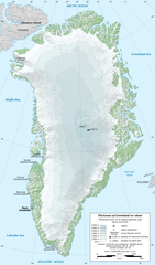
English: Map in English of Greenland ice sheet thickness. Thickness over 10 m above bedrock and mean sea level.
Français : Carte en anglais de l'épaisseur de l'inlandsis du Groenland. Épaisseur supérieure à 10 m au-dessus de la surface rocheuse et du niveau moyen des mers.
Lambert conformal conic projection; WGS84 datum
standard parallels: 66° N - 78° N
central meridian: 42° W
Scale: 1:8,000,000 (precision: 2 km)
Tarix
Mənbə
Öz işi
Sources used:
NGDC ETOPO1 (public domain)
Location of GISP2 drill: NCDC/NOAA
Müəllif
Eric Gaba (Sting - fr:Sting)
İcazə (Faylın təkrar istifadəsi)
Attribution and Share-Alike required
Any use of this map can be made as long as you credit me (Eric Gaba – Wikimedia Commons user: Sting) as the author and distribute the copies and derivative works under the same license(s) that the one(s) stated below. A message with a reply address would also be greatly appreciated.
Digər versiyalar
[redaktə]
ingilis (SVG)
ingilis (PNG)
fransız (PNG)
gürcü
makedon
polyak
Camera location
76° 00′ 00″ N, 42° 00′ 00″ W
View this and other nearby images on: OpenStreetMap
76.000000; -42.000000
Bu xəritə Qrafik emalatxanada (fr) yaradılmışdır. Siz həmçinin təsvirin yaxşılaşması ilə bağlı müraciət edə bilərsiniz.
Lisenziya
Eric Gaba (Wikimedia Commons user Sting), the copyright holder of this work, hereby publishes it under the following license:
Bu fayl Creative Commons Attribution-Share Alike 3.0 Sinqapur lisenziyası altında yayımlanır.
İstinad: Eric Gaba (Wikimedia Commons user Sting)
Azadsınız:
paylaşmaq – əsəri köçürmək, paylamaq və ötürmək üçün
remiks etmək – əsəri adaptasiya etmək
Aşağıdakı şərtlərə riayət etməklə:
istinad – Müvafiq kredit verməlisiniz, lisenziyaya bir keçid verməlisiniz və dəyişikliklərin olub olmadığını bildirməlisiniz. Bunu hər hansı bir ağlabatan şəkildə edə bilərsiniz, ancaq lisenziyalaşdırıcının sizi və ya istifadənizi təsdiqləməsini təklif edən bir şəkildə deyil.
bənzər paylaşma – Əsəri remix edirsinizsə, dəyişdirirsinizsə və ya üzərində iş aparırsınızsa, öz töhfələrinizi orijinalda olduğu kimi eyni və ya uyğun lisenziya altında yayımlamalısınız.
== {{int:filedesc}} == {{Information |Description={{en|Map in English of Greenland ice sheet thickness. Thickness over 10 m above bedrock and mean sea level.}} {{fr|Carte en anglais de l'épaisseur de l'[[:fr:Inlandsis du Groen
List of active separatist movements in North America
User:Northamerica1000/Topics
Geografía de Groenlandia
Tsunami de Groenlandia de 2017
Bassgeiger hadművelet
Edelweiss hadművelet
Edelweiss II hadművelet
Jégpajzs
გრენლანდიის გეოგრაფია
Список ссавців Гренландії
Список птахів Гренландії
Острів Гренландія
Dekabr 31, 2022
fayl, greenland, sheet, amsl, thickness, fayl, faylın, tarixçəsi, istifadə, edilən, səhifələr, faylın, qlobal, istifadəsisınaq, göstərişi, ölçüsü, piksel, digər, ölçülər, piksel, piksel, piksel, piksel, faylın, orijinalı, 8206, piksel, fayl, həcmi, mime, növü,. Fayl Faylin tarixcesi Istifade edilen sehifeler Faylin qlobal istifadesiSinaq gosterisi olcusu 351 599 piksel Diger olculer 141 240 piksel 281 480 piksel 450 768 piksel 1 056 1 801 piksel Faylin orijinali 8206 1 056 1 801 piksel fayl hecmi 1 MB MIME novu image png Bu fayl Vikimedia Commons dadirve diger layihelerde istifade edile biler Faylin tesvir sehifesine get Xulase IzahGreenland ice sheet AMSL thickness map en png English Map in English of Greenland ice sheet thickness Thickness over 10 m above bedrock and mean sea level Francais Carte en anglais de l epaisseur de l inlandsis du Groenland Epaisseur superieure a 10 m au dessus de la surface rocheuse et du niveau moyen des mers Lambert conformal conic projection WGS84 datumstandard parallels 66 N 78 N central meridian 42 WScale 1 8 000 000 precision 2 km Tarix yanvar 2011Menbe Oz isi Sources used NGDC ETOPO1 public domain Location of GISP2 drill NCDC NOAAMuellif Eric Gaba Sting fr Sting Icaze Faylin tekrar istifadesi Attribution and Share Alike requiredAny use of this map can be made as long as you credit me Eric Gaba Wikimedia Commons user Sting as the author and distribute the copies and derivative works under the same license s that the one s stated below A message with a reply address would also be greatly appreciated Diger versiyalar redakte ingilis SVG ingilis PNG fransiz PNG gurcu makedon polyak Camera location76 00 00 N 42 00 00 W View this and other nearby images on OpenStreetMap76 000000 42 000000Bu xerite Qrafik emalatxanada fr yaradilmisdir Siz hemcinin tesvirin yaxsilasmasi ile bagli muraciet ede bilersiniz Lisenziya Eric Gaba Wikimedia Commons user Sting the copyright holder of this work hereby publishes it under the following license Bu fayl Creative Commons Attribution Share Alike 3 0 Sinqapur lisenziyasi altinda yayimlanir Istinad Eric Gaba Wikimedia Commons user Sting Azadsiniz paylasmaq eseri kocurmek paylamaq ve oturmek ucun remiks etmek eseri adaptasiya etmek Asagidaki sertlere riayet etmekle istinad Muvafiq kredit vermelisiniz lisenziyaya bir kecid vermelisiniz ve deyisikliklerin olub olmadigini bildirmelisiniz Bunu her hansi bir aglabatan sekilde ede bilersiniz ancaq lisenziyalasdiricinin sizi ve ya istifadenizi tesdiqlemesini teklif eden bir sekilde deyil benzer paylasma Eseri remix edirsinizse deyisdirirsinizse ve ya uzerinde is aparirsinizsa oz tohfelerinizi orijinalda oldugu kimi eyni ve ya uygun lisenziya altinda yayimlamalisiniz https creativecommons org licenses by sa 3 0 CC BY SA 3 0 Creative Commons Attribution Share Alike 3 0 true trueCaptionsazerbaycancaAdd a one line explanation of what this file representsItems portrayed in this filetesvir ediryaradiciSome value without a Vikiverilenler itemmuellifin qisa adi StingWikimedia username ingilis StingURL ingilis http commons wikimedia org wiki User Stingcopyright status ingiliscopyrighted ingilislisenziyaCreative Commons Attribution ShareAlike 3 0 Unported ingilissource of file ingilisoriginal creation by uploader ingilisyaranma tarixiyanvar 2011coordinates of the point of view ingilis76 0 0 000 N 42 0 0 000 W Faylin tarixcesi Faylin evvelki versiyasini gormek ucun gun tarix bolmesindeki tarixlere klikleyin Tarix VaxtKicik sekilOlculerIstifadeciSerh indiki20 12 13 fevral 20111 056 1 801 1 MB Ras67cropped 18 56 3 yanvar 20111 060 1 805 1 17 MB Sting int filedesc Information Description en Map in English of Greenland ice sheet thickness Thickness over 10 m above bedrock and mean sea level fr Carte en anglais de l 039 epaisseur de l 039 fr Inlandsis du Groen Istifade edilen sehifeler Bu sekile olan kecidler ATOW1996 Qrenlandiya adasi Faylin qlobal istifadesi Bu fayl asagidaki vikilerde istifade olunur ar wikipedia org layihesinde istifadesi جغرافيا غرينلاند ast wikipedia org layihesinde istifadesi Territorios especiales de la Xunion Europea be tarask wikipedia org layihesinde istifadesi Spis garadoy Grenlyandyi be wikipedia org layihesinde istifadesi Garady Grenlandyi bn wikipedia org layihesinde istifadesi গ র নল য ন ড র ভ গ ল ca wikipedia org layihesinde istifadesi Groenlandia Territoris especials de la Unio Europea cs wikipedia org layihesinde istifadesi Gronsky ledovec en wikipedia org layihesinde istifadesi Greenland Geography of Greenland Climate of the Arctic List of rivers of Greenland List of active separatist movements in North America User Northamerica1000 Topics es wikipedia org layihesinde istifadesi Groenlandia Geografia de Groenlandia Tsunami de Groenlandia de 2017 he wikipedia org layihesinde istifadesi גאומורפולוגיה קרחונית hu wikipedia org layihesinde istifadesi Holzauge hadmuvelet Bassgeiger hadmuvelet Edelweiss hadmuvelet Edelweiss II hadmuvelet Jegpajzs ja wikipedia org layihesinde istifadesi グリーンランド ka wikipedia org layihesinde istifadesi გრენლანდია გრენლანდიის გეოგრაფია nl wikipedia org layihesinde istifadesi Geografie van Groenland pl wikipedia org layihesinde istifadesi Geografia Grenlandii ru wikipedia org layihesinde istifadesi Spisok mlekopitayushih Grenlandii sd wikipedia org layihesinde istifadesi گرين لينڊ sv wikipedia org layihesinde istifadesi Wikipedia Onskelistor fran Wikidata Manga lankar Efter land Danmark uk wikipedia org layihesinde istifadesi Mista Grenlandiyi Spisok ssavciv Grenlandiyi Spisok ptahiv Grenlandiyi Ostriv Grenlandiya www wikidata org layihesinde istifadesi Q2034298 xmf wikipedia org layihesinde istifadesi გრენლანდია Menbe https az wikipedia org wiki Fayl Greenland ice sheet AMSL thickness map en png, wikipedia, oxu, kitab, kitabxana, axtar, tap, hersey,
ne axtarsan burda
, en yaxsi meqale sayti, meqaleler, kitablar, oyrenmek, wiki, bilgi, tarix, seks, porno, indir, yukle, sex, azeri sex, azeri, seks yukle, sex yukle, izle, seks izle, porno izle, mobil seks, telefon ucun, chat, azeri chat, tanisliq, tanishliq, azeri tanishliq, sayt, medeni, medeni saytlar, chatlar, mekan, tanisliq mekani, mekanlari, yüklə, pulsuz, pulsuz yüklə, mp3, video, mp4, 3gp, jpg, jpeg, gif, png, şəkil, muisiqi, mahnı, kino, film, kitab, oyun, oyunlar.