Bu fayl "Vikimedia Commons"dadır və digər layihələrdə istifadə edilə bilər.
Faylın təsvir səhifəsinə get
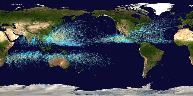
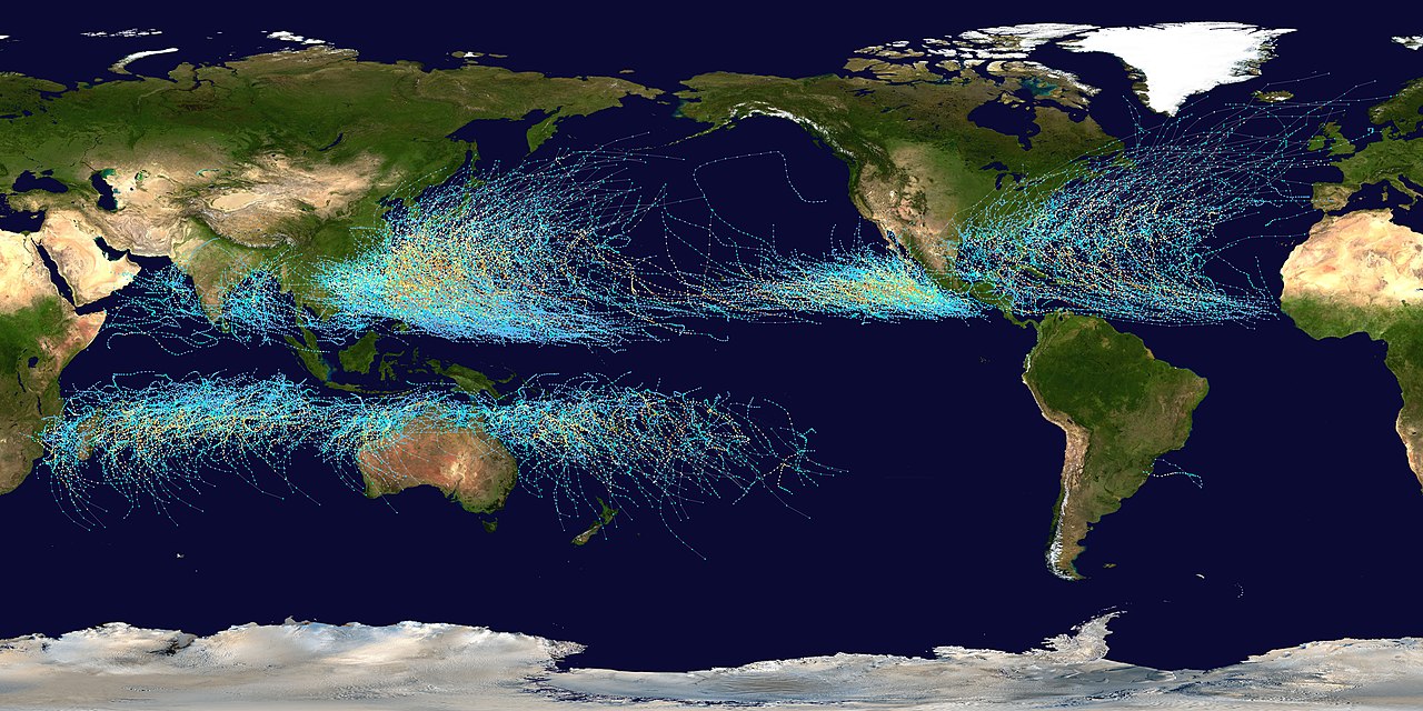
Saffir-Simpson Hurricane Scale
TD
TS
1
2
3
4
5
İzahGlobal tropical cyclone tracks-edit2.jpg
Čeština: Světové tropické cyklony v letech 1985 - 2005
English: This map shows the tracks of all Tropical cyclones which formed worldwide from 1985 to 2005. The points show the locations of the storms at six-hourly intervals and use the color scheme shown to the right from the Saffir-Simpson Hurricane Scale. However, remnants of the storms are not shown as triangles.
Español: Este mapa muestra los recorridos de todos los ciclones tropicales, que se formaron desde 1985 hasta 2005. Los puntos muestran las localizaciones de las tormentas en intervalos de seis horas, y utilizan el esquema de color (a la derecha) de la Escala de huracanes de Saffir-Simpson.
Deutsch: Diese Karte zeigt die Verlaufsbahnen der Tropischen Wirbelstürme von 1985 bis 2005. Die farbigen Punkte zeigen die Positionen der Stürme in sechs-stündlichen Abständen und verdeutlichen die Intensität eines Sturmes zu diesen Zeitpunkten auf der Saffir-Simpson-Hurrikan-Skala.
Français : Cette carte montre les traces de tous les cyclones tropicaux qui se sont formés entre 1985 et 2005. Les points montrent l'emplacement des cyclones à des intervalles de six heures, et leur couleur indique leur intensité sur l'échelle de Saffir-Simpson.
Português: Esse mapa mostra as rotas de todos os ciclones tropicais que se formaram entre 1985 e 2005. Os pontos indicam suas localizações, registradas a cada seis horas. O esquema de cores ao lado é baseado na escala Saffir-Simpson.
Tagalog: Ang mapang ito ay nagpapakita ng dinaanan ng mga bagyo sa buong mundo mula 1985 hanggang 2005. Ang mga tuldok ay nagpapakita ng galaw ng bagyo kada anim na oras. Makikita rin ang ibat-iang kulay ng bawat linya na magbibigay impormasyon sa lakas o hina ng isang isang bagyo sa pamamagitan Saffir-Simpson Hurricane Scale.
Türkçe: Bu harita, 1985 ile 2005 yıları arasında dünyada meydana gelen tüm tropik kasırgaların hareketlerini göstermektedir. Her bir nokta altı saatlik aralarla kasırganın yerini, kullanılan renkler ise kasırgaların, Saffir-Simpson ölçeğine göre şiddetlerini gösterir.
Русский: На этой карте показаны пути всех тропических циклонов за 1985-2005 гг. На каждом пути точки соответствуют положениям циклона через каждые 6 часов; их цвет указывает силу циклона по шкале Саффира-Симпсона
Slovenčina: Táto mapa ukazuje trasy všetkých tropických cyklónov, ktoré sa vytvorili po celom svete v rokoch 1985 až 2005. Body ukazujú umiestenie búrky v šesťhodinových intervaloch a používajú farebnú škálu zobrazenú vpravo podľa Saffirovej-Simpsonej hurikánovej stupnice.
Created using User:jdorje/Tracks by Nilfanion on 2006-08-05. Background image from File:Whole_world_-_land_and_oceans.jpg (NASA).
Tracking data for storms within the Atlantic and Eastern Pacific basins is taken from the National Hurricane Center and the Central Pacific Hurricane Center's Northeast and North Central Pacific hurricane database. The tracking data for storms within the Indian Ocean, the Northwest Pacific and the Southern Pacific is from the Joint Typhoon Warning Center. Tracking data for Cyclone Catarina in the South Atlantic was published in Gary Padgett's April 2004 Monthly Tropical Cyclone Summary and was originally produced by Roger Edson of the University of Guam.
Müəllif
Background image: NASA
this version: Nilfanion
İcazə (Faylın təkrar istifadəsi)
Public domainPublic domainfalsefalse
Used within
Mogil, H. Michael. Extreme Weather: Understanding the Science of Hurricanes, Tornadoes, Floods, Heat Waves, Snow Storms, Global Warming and Other Atmospheric Disturbances, pp. 61. (Hardcover - Nov 13, 2007)
Awards
This file was a candidate in Picture of the Year 2006. This file was the picture of the day on yanvar 06, 2007. This is a featured picture on Wikimedia Commons (Featured pictures) and is considered one of the finest images.
Vikipediya
This is a featured picture on the alman language Wikipedia (Exzellente Bilder) and is considered one of the finest images. This is a featured picture on the ingilis language Wikipedia (Featured pictures) and is considered one of the finest images. This is a featured picture on the ispan language Wikipedia (Recursos destacados) and is considered one of the finest images. This is a featured picture on the türk language Wikipedia (Seçkin resimler) and is considered one of the finest images.
If you have an image of similar quality that can be published under a suitable copyright license, be sure to upload it, tag it, and nominate it.
This image was selected as picture of the day on Wikimedia Commons for 6 January 2007. It was captioned as follows:
English: Worldwide Tropical cyclones from 1985 to 2005
Svenska: Karta över tropiska cykloner mellan 1985 och 2005.
Türkçe: 1985 ile 2005 arasında meydana gelmiş Dünya'daki tüm tropik kasırgaların haritası.
Български: Карта на тропическите циклони в световен мащаб от 1995 г. до 2005 г.
Русский: Карта тропических циклонов 1985-2005 годов.
日本語: 1985年から2005年までの熱帯低気圧
中文: 1985年至2005年的热带气旋分布
中文(繁體): 1985年至2005年世界各地的熱帶氣旋分佈圖
Valued image
This image has been assessed under the valued image criteria and is considered the most valued image on Commons within the scope: Global cumulative tropical cyclone tracks. You can see its nomination here.
Captions
Add a one-line explanation of what this file represents
Worldwide map of all tropical cyclone tracks between 1985 and 2005.
Мировая карта траекторий тропических циклонов в период 1985-2005 г.г.
Items portrayed in this file
təsvir edir
coğrafi xəritə
meteorologiya
copyright status ingilis
copyrighted, dedicated to the public domain by copyright holder ingilis
lisenziya
released into the public domain by the copyright holder ingilis
Commons quality assessment ingilis
Wikimedia Commons featured picture ingilis
Wikimedia Commons valued image ingilis
başlama tarixi: 28 iyul 2022
yaranma tarixi
2020
Faylın tarixçəsi
Faylın əvvəlki versiyasını görmək üçün gün/tarix bölməsindəki tarixlərə klikləyin.
== Summary == This map shows the tracks of all Tropical cyclones which formed worldwide from 1985 to 2005. The points show the locations of the storms at six-hourly intervals and use the color scheme from [[w:Saffir-Simpson Hurrican
fayl, global, tropical, cyclone, tracks, edit2, fayl, faylın, tarixçəsi, istifadə, edilən, səhifələr, faylın, qlobal, istifadəsisınaq, göstərişi, ölçüsü, piksel, digər, ölçülər, piksel, piksel, piksel, piksel, piksel, piksel, faylın, orijinalı, 8206, piksel, f. Fayl Faylin tarixcesi Istifade edilen sehifeler Faylin qlobal istifadesiSinaq gosterisi olcusu 800 400 piksel Diger olculer 320 160 piksel 640 320 piksel 1 024 512 piksel 1 280 640 piksel 2 560 1 280 piksel 8 000 4 000 piksel Faylin orijinali 8206 8 000 4 000 piksel fayl hecmi 5 73 MB MIME novu image jpeg Bu fayl Vikimedia Commons dadirve diger layihelerde istifade edile biler Faylin tesvir sehifesine get Saffir Simpson Hurricane ScaleTD TS 1 2 3 4 5IzahGlobal tropical cyclone tracks edit2 jpg Cestina Svetove tropicke cyklony v letech 1985 2005 English This map shows the tracks of all Tropical cyclones which formed worldwide from 1985 to 2005 The points show the locations of the storms at six hourly intervals and use the color scheme shown to the right from the Saffir Simpson Hurricane Scale However remnants of the storms are not shown as triangles Espanol Este mapa muestra los recorridos de todos los ciclones tropicales que se formaron desde 1985 hasta 2005 Los puntos muestran las localizaciones de las tormentas en intervalos de seis horas y utilizan el esquema de color a la derecha de la Escala de huracanes de Saffir Simpson Deutsch Diese Karte zeigt die Verlaufsbahnen der Tropischen Wirbelsturme von 1985 bis 2005 Die farbigen Punkte zeigen die Positionen der Sturme in sechs stundlichen Abstanden und verdeutlichen die Intensitat eines Sturmes zu diesen Zeitpunkten auf der Saffir Simpson Hurrikan Skala Francais Cette carte montre les traces de tous les cyclones tropicaux qui se sont formes entre 1985 et 2005 Les points montrent l emplacement des cyclones a des intervalles de six heures et leur couleur indique leur intensite sur l echelle de Saffir Simpson Portugues Esse mapa mostra as rotas de todos os ciclones tropicais que se formaram entre 1985 e 2005 Os pontos indicam suas localizacoes registradas a cada seis horas O esquema de cores ao lado e baseado na escala Saffir Simpson Tagalog Ang mapang ito ay nagpapakita ng dinaanan ng mga bagyo sa buong mundo mula 1985 hanggang 2005 Ang mga tuldok ay nagpapakita ng galaw ng bagyo kada anim na oras Makikita rin ang ibat iang kulay ng bawat linya na magbibigay impormasyon sa lakas o hina ng isang isang bagyo sa pamamagitan Saffir Simpson Hurricane Scale Turkce Bu harita 1985 ile 2005 yilari arasinda dunyada meydana gelen tum tropik kasirgalarin hareketlerini gostermektedir Her bir nokta alti saatlik aralarla kasirganin yerini kullanilan renkler ise kasirgalarin Saffir Simpson olcegine gore siddetlerini gosterir Russkij Na etoj karte pokazany puti vseh tropicheskih ciklonov za 1985 2005 gg Na kazhdom puti tochki sootvetstvuyut polozheniyam ciklona cherez kazhdye 6 chasov ih cvet ukazyvaet silu ciklona po shkale Saffira Simpsona Slovencina Tato mapa ukazuje trasy vsetkych tropickych cyklonov ktore sa vytvorili po celom svete v rokoch 1985 az 2005 Body ukazuju umiestenie burky v sesthodinovych intervaloch a pouzivaju farebnu skalu zobrazenu vpravo podľa Saffirovej Simpsonej hurikanovej stupnice 中文 此地圖展示自1985年至2005年間世界各地熱帶氣旋分佈及路徑 路徑以每6小時為一點 並按薩菲爾 辛普森颶風等級 Saffir Simpson Hurricane Scale 分為不同顏色 Tarix 5 avqust 2006Menbe Created using User jdorje Tracks by Nilfanion on 2006 08 05 Background image from File Whole world land and oceans jpg NASA Tracking data for storms within the Atlantic and Eastern Pacific basins is taken from the National Hurricane Center and the Central Pacific Hurricane Center s Northeast and North Central Pacific hurricane database The tracking data for storms within the Indian Ocean the Northwest Pacific and the Southern Pacific is from the Joint Typhoon Warning Center Tracking data for Cyclone Catarina in the South Atlantic was published in Gary Padgett s April 2004 Monthly Tropical Cyclone Summary and was originally produced by Roger Edson of the University of Guam Muellif Background image NASA this version NilfanionIcaze Faylin tekrar istifadesi Public domain Public domain false falseMen bu eserin muellif huquqlarinin sahibi kimi eseri ictimai mulkiyyete verirem Bu icaze butun dunyada quvvededir In some countries this may not be legally possible if so Bunun qanunla mumkun olmadigi hallarda Istenilen sexse istenilen meqsed ucun qanunlar terefinden qadagan edilmeyince hec bir sert qoymadan bu isden istifade haqqini bagislayiram Used within Mogil H Michael Extreme Weather Understanding the Science of Hurricanes Tornadoes Floods Heat Waves Snow Storms Global Warming and Other Atmospheric Disturbances pp 61 Hardcover Nov 13 2007 Awards This file was a candidate in Picture of the Year 2006 This file was the picture of the day on yanvar 06 2007 This is a featured picture on Wikimedia Commons Featured pictures and is considered one of the finest images Vikipediya This is a featured picture on the alman language Wikipedia Exzellente Bilder and is considered one of the finest images This is a featured picture on the ingilis language Wikipedia Featured pictures and is considered one of the finest images This is a featured picture on the ispan language Wikipedia Recursos destacados and is considered one of the finest images This is a featured picture on the turk language Wikipedia Seckin resimler and is considered one of the finest images If you have an image of similar quality that can be published under a suitable copyright license be sure to upload it tag it and nominate it This image was selected as picture of the day on Wikimedia Commons for 6 January 2007 It was captioned as follows English Worldwide Tropical cyclones from 1985 to 2005Other languages Ban lam gu Ui 1985 ni kau 2005 ni choan se kai e jia t tai ke khi ap Cestina Svetove tropicke cyklony v letech 1985 2005Dansk Kort over tropiske cykloner mellem 1985 og 2005 Deutsch Die Verlaufsbahnen der Tropischen Wirbelsturme von 1985 bis 2005English Worldwide Tropical cyclones from 1985 to 2005Espanol Mapa mundial de ciclones tropicales entre los anos 1985 y 2005 Francais Carte des cyclones tropicaux entre 1985 et 2005Galego Mapamundi dos tifons entre 1985 e 2005Italiano Mappa mondiale dei cicloni tropicali dal 1985 al 2005 Magyar Vilagmeretu tropikus ciklonok 1985 tol 2005 igPolski Mapa cyklonow tropikalnych na swiecie w latach 1985 2005Romană Hartă de compoziție care indică toate cicloanele tropicale dintre 1985 și 2005 Sicilianu Mappa munniali de cicluna trupicali do 1985 o 2005 Suomi Trooppiset hirmumyrskyt 1985 2005 Saffirin Simpsonin hurrikaaniasteikolla esitettynaSvenska Karta over tropiska cykloner mellan 1985 och 2005 Turkce 1985 ile 2005 arasinda meydana gelmis Dunya daki tum tropik kasirgalarin haritasi Blgarski Karta na tropicheskite cikloni v svetoven mashab ot 1995 g do 2005 g Russkij Karta tropicheskih ciklonov 1985 2005 godov 日本語 1985年から2005年までの熱帯低気圧中文 1985年至2005年的热带气旋分布中文 繁體 1985年至2005年世界各地的熱帶氣旋分佈圖 Valued imageThis image has been assessed under the valued image criteria and is considered the most valued image on Commons within the scope Global cumulative tropical cyclone tracks You can see its nomination here CaptionsazerbaycancaAdd a one line explanation of what this file representsingilisWorldwide map of all tropical cyclone tracks between 1985 and 2005 rusMirovaya karta traektorij tropicheskih ciklonov v period 1985 2005 g g Items portrayed in this filetesvir edircografi xeritemeteorologiyacopyright status ingiliscopyrighted dedicated to the public domain by copyright holder ingilislisenziyareleased into the public domain by the copyright holder ingilisCommons quality assessment ingilisWikimedia Commons featured picture ingilisWikimedia Commons valued image ingilisbaslama tarixi 28 iyul 2022yaranma tarixi2020 Faylin tarixcesi Faylin evvelki versiyasini gormek ucun gun tarix bolmesindeki tarixlere klikleyin Tarix VaxtKicik sekilOlculerIstifadeciSerh indiki12 10 19 mart 20208 000 4 000 5 73 MB SupportstormReverted to version as of 00 36 5 August 2006 UTC 01 40 27 fevral 20201 920 960 482 KB JDD Sickook some body update this its almost 15 years old also i made no changes 00 36 5 avqust 20068 000 4 000 5 73 MB Nilfanion Summary This map shows the tracks of all Tropical cyclones which formed worldwide from 1985 to 2005 The points show the locations of the storms at six hourly intervals and use the color scheme from w Saffir Simpson Hurrican Istifade edilen sehifeler Bu sekile olan kecidler Bor hadisesi Faylin qlobal istifadesi Bu fayl asagidaki vikilerde istifade olunur af wikipedia org layihesinde istifadesi Wikipedia Beeld van die week 2016 Wikipedia Voorbladbeeld week 41 2016 als wikipedia org layihesinde istifadesi Tropischer Wirbelsturm ar wikipedia org layihesinde istifadesi إعصار قمعي عاصفة ثلجية خريف شتاء مناخ علم الأرصاد الجوية ثلج سحاب صيف تلوث الهواء مطر ربيع فصول السنة فيزياء الغلاف الجوي برد هطول عاصفة رملية ضباب موسم جاف موسم رطب عاصفة رعدية إعصار استوائي توقع جوي نيزك جليدي ضخم قالب طقس السحابة الخارقة هبوب دمق مناخ أصغري هرمتان رياح شاهقة مائية انقلاب صيفي غبار الألماس برد دقيق مطر متجمد حبيبات جليدية رذاذ متجمد مزن ركامي عاصفة جليدية موجة حر موجة برد عاصفة نارية خليط المطر والثلج انقلاب شتوي طقس قاسي استطلاع الطقس رذاذ حبيبات ثلجية Bu faylin qlobal istifadesine baxin Menbe https az wikipedia org wiki Fayl Global tropical cyclone tracks edit2 jpg, wikipedia, oxu, kitab, kitabxana, axtar, tap, hersey,
ne axtarsan burda
, en yaxsi meqale sayti, meqaleler, kitablar, oyrenmek, wiki, bilgi, tarix, seks, porno, indir, yukle, sex, azeri sex, azeri, seks yukle, sex yukle, izle, seks izle, porno izle, mobil seks, telefon ucun, chat, azeri chat, tanisliq, tanishliq, azeri tanishliq, sayt, medeni, medeni saytlar, chatlar, mekan, tanisliq mekani, mekanlari, yüklə, pulsuz, pulsuz yüklə, mp3, video, mp4, 3gp, jpg, jpeg, gif, png, şəkil, muisiqi, mahnı, kino, film, kitab, oyun, oyunlar.