Bu fayl "Vikimedia Commons"dadır və digər layihələrdə istifadə edilə bilər.
Faylın təsvir səhifəsinə get
Xülasə
İzahFranz Josef Land, Aug 2011.jpg
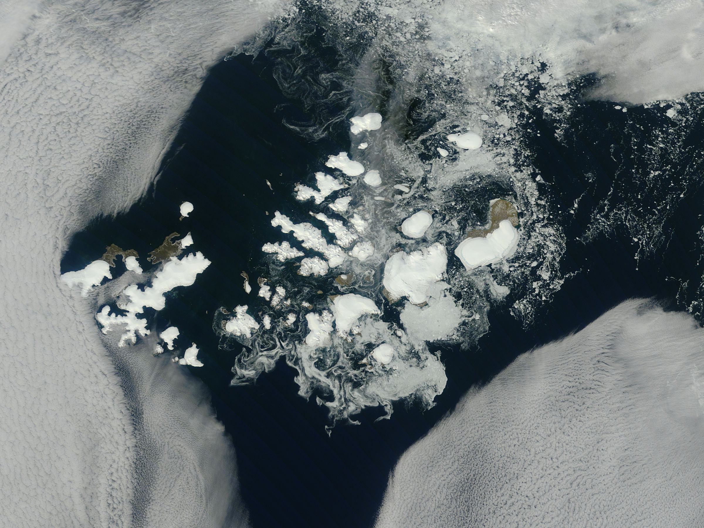
NASA image captured this true-color image on August 14, 2011
The clouds parted over the northeast Barents Sea region of the Arctic Ocean in late summer allowing a view of the ice-covered islands of Franz Josef Land (Russia) forming a stark-white contrast to the surrounding dark sea water. The Moderate Resolution Imaging Spectroradiometer (MODIS) aboard the Terra satellite captured this true-color image on August 14, 2011.
Franz Josef Land is an archipelago of 6 main islands and about 135 small islands, with a total landmass of about 16,134 square kilometers (6,229 square miles). The terrain is primarily elevated table lands and low hills, with the highest point rising to 620 m (2034 feet).
The glaciers on the islands of Franz Josef are currently in a state of retreat, and in this image large areas of the main islands clearly appear ice free. However, up to 85% of the island’s landmass is permanently ice-covered, with an average ice thickness of about 180 m (590 feet). On Graham Bell Island —the large island on the eastern edge of the group— the Windy Dome Ice Cap reaches a depth of greater than 500 m (1,640 feet). Although being late summer, sea ice can still be seen surrounding many of the islands.
Credit: NASA/GSFC/Jeff Schmaltz/MODIS Land Rapid Response Team
NASA Goddard Space Flight Center enables NASA’s mission through four scientific endeavors: Earth Science, Heliophysics, Solar System Exploration, and Astrophysics. Goddard plays a leading role in NASA’s accomplishments by contributing compelling scientific knowledge to advance the Agency’s mission.
Follow us on Twitter
Like us on Facebook
Find us on Instagram
Tarix
Mənbə
Franz Josef Land, Arctic Ocean
Uploaded by PDTillman
Müəllif
NASA Goddard Space Flight Center from Greenbelt, MD, USA
Lisenziya
Public domainPublic domainfalsefalse
Bu fayl Creative Commons Attribution 2.0 Generic lisenziyası altında yayımlanır.
Azadsınız:
paylaşmaq – əsəri köçürmək, paylamaq və ötürmək üçün
remiks etmək – əsəri adaptasiya etmək
Aşağıdakı şərtlərə riayət etməklə:
istinad – Müvafiq kredit verməlisiniz, lisenziyaya bir keçid verməlisiniz və dəyişikliklərin olub olmadığını bildirməlisiniz. Bunu hər hansı bir ağlabatan şəkildə edə bilərsiniz, ancaq lisenziyalaşdırıcının sizi və ya istifadənizi təsdiqləməsini təklif edən bir şəkildə deyil.
https://creativecommons.org/licenses/by/2.0CC BY 2.0 Creative Commons Attribution 2.0 truetrue
This image, originally posted to Flickr, was reviewed on August 31, 2011 by the administrator or reviewer File Upload Bot (Magnus Manske), who confirmed that it was available on Flickr under the stated license on that date.
Captions
Add a one-line explanation of what this file represents
{{Information |Description=NASA image captured this true-color image on August 14, 2011 The clouds parted over the northeast Barents Sea region of the Arctic Ocean in late summer, 2011 allowing a view of the ice-covered islands of Franz Josef Land, Russi
fayl, franz, josef, land, 2011, fayl, faylın, tarixçəsi, istifadə, edilən, səhifələr, faylın, qlobal, istifadəsisınaq, göstərişi, ölçüsü, piksel, digər, ölçülər, piksel, piksel, piksel, piksel, piksel, faylın, orijinalı, 8206, piksel, fayl, həcmi, mime, növü, . Fayl Faylin tarixcesi Istifade edilen sehifeler Faylin qlobal istifadesiSinaq gosterisi olcusu 800 600 piksel Diger olculer 320 240 piksel 640 480 piksel 1 024 768 piksel 1 280 960 piksel 2 400 1 800 piksel Faylin orijinali 8206 2 400 1 800 piksel fayl hecmi 812 KB MIME novu image jpeg Bu fayl Vikimedia Commons dadirve diger layihelerde istifade edile biler Faylin tesvir sehifesine get Xulase IzahFranz Josef Land Aug 2011 jpg NASA image captured this true color image on August 14 2011The clouds parted over the northeast Barents Sea region of the Arctic Ocean in late summer allowing a view of the ice covered islands of Franz Josef Land Russia forming a stark white contrast to the surrounding dark sea water The Moderate Resolution Imaging Spectroradiometer MODIS aboard the Terra satellite captured this true color image on August 14 2011 Franz Josef Land is an archipelago of 6 main islands and about 135 small islands with a total landmass of about 16 134 square kilometers 6 229 square miles The terrain is primarily elevated table lands and low hills with the highest point rising to 620 m 2034 feet The glaciers on the islands of Franz Josef are currently in a state of retreat and in this image large areas of the main islands clearly appear ice free However up to 85 of the island s landmass is permanently ice covered with an average ice thickness of about 180 m 590 feet On Graham Bell Island the large island on the eastern edge of the group the Windy Dome Ice Cap reaches a depth of greater than 500 m 1 640 feet Although being late summer sea ice can still be seen surrounding many of the islands Credit NASA GSFC Jeff Schmaltz MODIS Land Rapid Response TeamNASA Goddard Space Flight Center enables NASA s mission through four scientific endeavors Earth Science Heliophysics Solar System Exploration and Astrophysics Goddard plays a leading role in NASA s accomplishments by contributing compelling scientific knowledge to advance the Agency s mission Follow us on TwitterLike us on Facebook Find us on InstagramTarix 19 avqust 2011Menbe Franz Josef Land Arctic Ocean Uploaded by PDTillmanMuellif NASA Goddard Space Flight Center from Greenbelt MD USA Lisenziya Public domain Public domain false falseThis file is in the public domain in the United States because it was solely created by NASA NASA copyright policy states that NASA material is not protected by copyright unless noted See Template PD USGov NASA copyright policy page or JPL Image Use Policy Warnings Use of NASA logos insignia and emblems is restricted per U S law 14 CFR 1221 The NASA website hosts a large number of images from the Soviet Russian space agency and other non American space agencies These are not necessarily in the public domain Materials based on Hubble Space Telescope data may be copyrighted if they are not explicitly produced by the STScI 1 See also PD Hubble and Cc Hubble The SOHO ESA amp NASA joint project implies that all materials created by its probe are copyrighted and require permission for commercial non educational use 2 Images featured on the Astronomy Picture of the Day APOD web site may be copyrighted 3 The National Space Science Data Center NSSDC site has been known to host copyrighted content Its photo gallery FAQ states that all of the images in the photo gallery are in the public domain Unless otherwise noted Bu fayl Creative Commons Attribution 2 0 Generic lisenziyasi altinda yayimlanir Azadsiniz paylasmaq eseri kocurmek paylamaq ve oturmek ucun remiks etmek eseri adaptasiya etmek Asagidaki sertlere riayet etmekle istinad Muvafiq kredit vermelisiniz lisenziyaya bir kecid vermelisiniz ve deyisikliklerin olub olmadigini bildirmelisiniz Bunu her hansi bir aglabatan sekilde ede bilersiniz ancaq lisenziyalasdiricinin sizi ve ya istifadenizi tesdiqlemesini teklif eden bir sekilde deyil https creativecommons org licenses by 2 0 CC BY 2 0 Creative Commons Attribution 2 0 true true This image originally posted to Flickr was reviewed on August 31 2011 by the administrator or reviewer File Upload Bot Magnus Manske who confirmed that it was available on Flickr under the stated license on that date CaptionsazerbaycancaAdd a one line explanation of what this file representsItems portrayed in this filetesvir edircopyright status ingiliscopyrighted ingilislisenziyaCreative Commons Attribution 2 0 Generic ingilisyaranma tarixi19 avqust 2011source of file ingilisfile available on the internet ingilisistifadeci Flickrdescribed at URL ingilis https www flickr com photos gsfc 6058998729 Faylin tarixcesi Faylin evvelki versiyasini gormek ucun gun tarix bolmesindeki tarixlere klikleyin Tarix VaxtKicik sekilOlculerIstifadeciSerh indiki21 04 31 avqust 20112 400 1 800 812 KB File Upload Bot Magnus Manske Information Description NASA image captured this true color image on August 14 2011 The clouds parted over the northeast Barents Sea region of the Arctic Ocean in late summer 2011 allowing a view of the ice covered islands of Franz Josef Land Russi Istifade edilen sehifeler Bu sekile olan kecidler Avstriya bogazi Frans Iosif Torpagi Faylin qlobal istifadesi Bu fayl asagidaki vikilerde istifade olunur af wikipedia org layihesinde istifadesi Franz Josef land ar wikipedia org layihesinde istifadesi أرخبيل فرنسوا جوزيف avk wikipedia org layihesinde istifadesi Franz Josef tursia ba wikipedia org layihesinde istifadesi Franc Iosif Ere cs wikipedia org layihesinde istifadesi Zeme Frantiska Josefa cv wikipedia org layihesinde istifadesi Franc Iosif Cĕrĕ da wikipedia org layihesinde istifadesi Franz Josefs Land de wikipedia org layihesinde istifadesi Die Schrecken des Eises und der Finsternis Franz Josef Land el wikipedia org layihesinde istifadesi Gh toy Fragkiskoy Iwshf en wikipedia org layihesinde istifadesi Franz Josef Land fr wikipedia org layihesinde istifadesi Terre Francois Joseph lt wikipedia org layihesinde istifadesi Prano Juozapo Zeme oc wikipedia org layihesinde istifadesi Terra de Frances Josep pl wikipedia org layihesinde istifadesi Ziemia Franciszka Jozefa ru wikipedia org layihesinde istifadesi Zemlya Franca Iosifa Geografiya Arhangelskoj oblasti sco wikipedia org layihesinde istifadesi 30 August simple wikipedia org layihesinde istifadesi Franz Josef Land vi wikipedia org layihesinde istifadesi Zemlya Frantsa Iosifa Menbe https az wikipedia org wiki Fayl Franz Josef Land Aug 2011 jpg, wikipedia, oxu, kitab, kitabxana, axtar, tap, hersey,
ne axtarsan burda
, en yaxsi meqale sayti, meqaleler, kitablar, oyrenmek, wiki, bilgi, tarix, seks, porno, indir, yukle, sex, azeri sex, azeri, seks yukle, sex yukle, izle, seks izle, porno izle, mobil seks, telefon ucun, chat, azeri chat, tanisliq, tanishliq, azeri tanishliq, sayt, medeni, medeni saytlar, chatlar, mekan, tanisliq mekani, mekanlari, yüklə, pulsuz, pulsuz yüklə, mp3, video, mp4, 3gp, jpg, jpeg, gif, png, şəkil, muisiqi, mahnı, kino, film, kitab, oyun, oyunlar.