Bu fayl "Vikimedia Commons"dadır və digər layihələrdə istifadə edilə bilər.
təsvir səhifəsi
Faylın təsvir səhifəsinə get
Xülasə
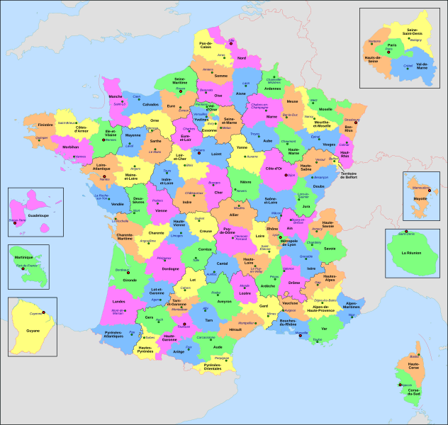
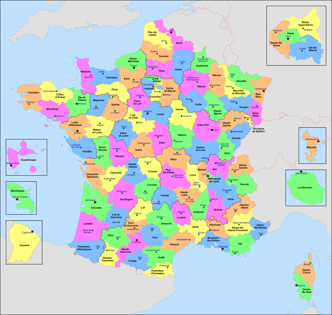
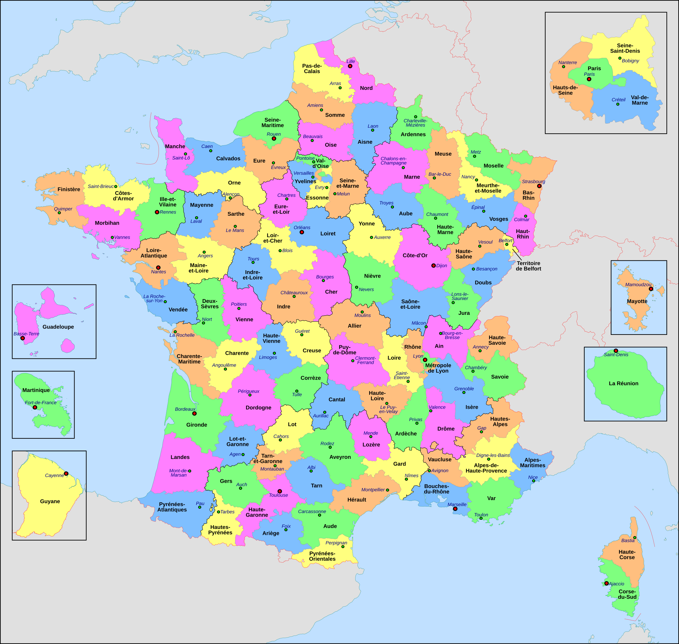
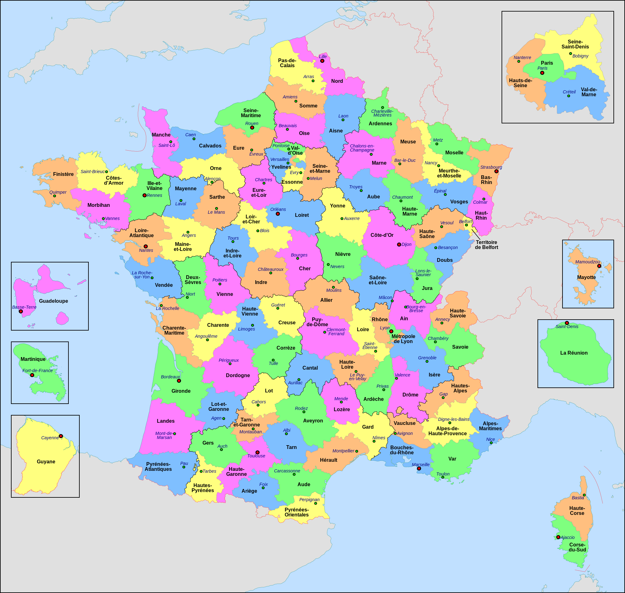
İzahFrance départementale.svg
Français : Carte administrative de la France, créée sous Inkscape 0.47 à partir de plusieurs des excellentes cartes (notamment celle-ci) créées par Sting : merci (et bravo) à lui.
Le fichier comporte vingt-quatre calques : Cadre, Chef-lieux de région, Villes, Chef-lieux de département, Numéros de département, Noms des régions, Nom des départements, **Encarts Départements d'Outre-Mer, **Encart Paris-Petite-Couronne, Coordonnées, Échelle et Mini-carte, Frontières internationales, Côtes, Limites régionales, Limites départementales, Lacs, Fleuves, *Régions métropolitaines, *Départements métropolitains, Terres françaises, Terres étrangères, Mers et océans, Échelle altimétrique, Topographie.
Calque visible Calque caché
L'astérisque signale un calque comportant des sous-calques
La double astérisque signale un calque comportant des sous-calques dont certains comportent eux-mêmes des sous-calques
English: Administrative map of France, created under Inkscape 0.47 from several of the excellent maps (especially this one) created by Sting: thanks (and congrats) to him.
The file consists of twenty-four layers: Frame, Administrative Centres of Regions, Towns, Administrative Centres of Departments, Numbers of Departments, Names of Regions, Names of Departments, **Overseas Departements Insets, **Paris Conurbation Inset, Coordinates, Scale and Mini-map, International boundaries, Coasts, Regional boundaries, Departmental boundaries, Lakes, Rivers, *Metropolitan Regions, *Metropolitan Departments, French lands, Foreign lands, Seas and Oceans, Altimetric Scale, Topography.
Visible Layer Hidden Layer
The asterisk indicates a layer with sublayers
The double asterisk indicates a layer with sublayers, some of which have sublayers
Tarix
Mənbə
Öz işi
Müəllif
Nilstilar
Digər versiyalar
arpetan
català
македонски
SVG genesis
InfoField
The SVG code is valid.
This map was created with Inkscape.
This map uses embedded text that can be easily translated using a text editor.
Lisenziya
I, the copyright holder of this work, hereby publish it under the following license:
This file is licensed under the Creative Commons Attribution-Share Alike 4.0 International license.
Azadsınız:
paylaşmaq – əsəri köçürmək, paylamaq və ötürmək üçün
remiks etmək – əsəri adaptasiya etmək
Aşağıdakı şərtlərə riayət etməklə:
istinad – Müvafiq kredit verməlisiniz, lisenziyaya bir keçid verməlisiniz və dəyişikliklərin olub olmadığını bildirməlisiniz. Bunu hər hansı bir ağlabatan şəkildə edə bilərsiniz, ancaq lisenziyalaşdırıcının sizi və ya istifadənizi təsdiqləməsini təklif edən bir şəkildə deyil.
bənzər paylaşma – Əsəri remix edirsinizsə, dəyişdirirsinizsə və ya üzərində iş aparırsınızsa, öz töhfələrinizi orijinalda olduğu kimi eyni və ya uyğun lisenziya altında yayımlamalısınız.
This image is used on a user page of a Wikimedia user and is stored on Commons according to the rules set out in Commons:Project scope#File in use on Commons only: the uploading of small numbers of images (e.g. of yourself) for use on a personal Commons user page is allowed or Commons:Project scope#File in use in another Wikimedia project: the uploading of small numbers of images (e.g. of yourself) for use on a personal user page of another project is allowed as long as that user is or was an active participant on that project. If the image ceases to be used it may be eligible for deletion as it may have no educational purpose.
dansk ∙ Deutsch ∙ English ∙ español ∙ français ∙ italiano ∙ Nederlands ∙ português ∙ sicilianu ∙ svenska ∙ македонски ∙ नेपाली ∙ മലയാളം ∙ 한국어 ∙ 日本語 ∙ 中文(简体) ∙ 中文(繁體) ∙ +/−
Captions
Add a one-line explanation of what this file represents
Bu faylda fotoaparat və ya skanerlə əlavə olunmuş məlumatlar var. Əgər fayl sonradan redaktə olunubsa, bəzi parametrlər bu şəkildə göstərilənlərdən fərqli ola bilər.
Genişlik
2000
Hündürlük
1898
İyul 15, 2023
fayl, france, départementale, fayl, faylın, tarixçəsi, fayl, keçidləri, faylın, qlobal, istifadəsi, metaməlumatlarbu, faylın, formatındakı, görünüşünün, ölçüsü, piksel, digər, ölçülər, piksel, piksel, piksel, piksel, piksel, piksel, faylın, orijinalı, 8206, fa. Fayl Faylin tarixcesi Fayl kecidleri Faylin qlobal istifadesi MetamelumatlarBu SVG faylin PNG formatindaki bu gorunusunun olcusu 632 600 piksel Diger olculer 253 240 piksel 506 480 piksel 809 768 piksel 1 079 1 024 piksel 2 158 2 048 piksel 2 000 1 898 piksel Faylin orijinali 8206 SVG fayli nominal olaraq 2 000 1 898 piksel faylin olcusu 1 87 MB Bu fayl Vikimedia Commons dadirve diger layihelerde istifade edile biler tesvir sehifesi Faylin tesvir sehifesine get Xulase IzahFrance departementale svg Francais nbsp Carte administrative de la France creee sous Inkscape 0 47 a partir de plusieurs des excellentes cartes notamment celle ci creees par Sting nbsp merci et bravo a lui Le fichier comporte vingt quatre calques nbsp Cadre Chef lieux de region Villes Chef lieux de departement Numeros de departement Noms des regions Nom des departements Encarts Departements d Outre Mer Encart Paris Petite Couronne Coordonnees Echelle et Mini carte Frontieres internationales Cotes Limites regionales Limites departementales Lacs Fleuves Regions metropolitaines Departements metropolitains Terres francaises Terres etrangeres Mers et oceans Echelle altimetrique Topographie Calque visible Calque cache L asterisque signale un calque comportant des sous calques La double asterisque signale un calque comportant des sous calques dont certains comportent eux memes des sous calques English Administrative map of France created under Inkscape 0 47 from several of the excellent maps especially this one created by Sting thanks and congrats to him The file consists of twenty four layers Frame Administrative Centres of Regions Towns Administrative Centres of Departments Numbers of Departments Names of Regions Names of Departments Overseas Departements Insets Paris Conurbation Inset Coordinates Scale and Mini map International boundaries Coasts Regional boundaries Departmental boundaries Lakes Rivers Metropolitan Regions Metropolitan Departments French lands Foreign lands Seas and Oceans Altimetric Scale Topography Visible Layer Hidden Layer The asterisk indicates a layer with sublayers The double asterisk indicates a layer with sublayers some of which have sublayers Tarix 25 iyul 2010 Menbe Oz isi Muellif Nilstilar Diger versiyalar arpetan catala makedonski SVG nbsp genesisInfoField nbsp The SVG code is valid nbsp This map was created with Inkscape nbsp This map uses embedded text nbsp that can be easily translated using a text editor Lisenziya I the copyright holder of this work hereby publish it under the following license This file is licensed under the Creative Commons Attribution Share Alike 4 0 International license Azadsiniz paylasmaq eseri kocurmek paylamaq ve oturmek ucun remiks etmek eseri adaptasiya etmek Asagidaki sertlere riayet etmekle istinad Muvafiq kredit vermelisiniz lisenziyaya bir kecid vermelisiniz ve deyisikliklerin olub olmadigini bildirmelisiniz Bunu her hansi bir aglabatan sekilde ede bilersiniz ancaq lisenziyalasdiricinin sizi ve ya istifadenizi tesdiqlemesini teklif eden bir sekilde deyil benzer paylasma Eseri remix edirsinizse deyisdirirsinizse ve ya uzerinde is aparirsinizsa oz tohfelerinizi orijinalda oldugu kimi eyni ve ya uygun lisenziya altinda yayimlamalisiniz https creativecommons org licenses by sa 4 0 CC BY SA 4 0 Creative Commons Attribution Share Alike 4 0 true true This image is used on a user page of a Wikimedia user and is stored on Commons according to the rules set out in Commons Project scope File in use on Commons only the uploading of small numbers of images e g of yourself for use on a personal Commons user page is allowed or Commons Project scope File in use in another Wikimedia project the uploading of small numbers of images e g of yourself for use on a personal user page of another project is allowed as long as that user is or was an active participant on that project If the image ceases to be used it may be eligible for deletion as it may have no educational purpose dansk nbsp Deutsch nbsp English nbsp espanol nbsp francais nbsp italiano nbsp Nederlands nbsp portugues nbsp sicilianu nbsp svenska nbsp makedonski nbsp न प ल nbsp മലയ ള nbsp 한국어 nbsp 日本語 nbsp 中文 简体 nbsp 中文 繁體 nbsp CaptionsazerbaycancaAdd a one line explanation of what this file representsfransizDJ STARItems portrayed in this filetesvir edirFransa departamentiyaradicisome valuemuellifin qisa adi NilstilarWikimedia username nbsp ingilis NilstilarURL http commons wikimedia org wiki User Nilstilarcopyright status nbsp ingiliscopyrighted nbsp ingilislisenziyaCreative Commons Attribution ShareAlike 4 0 International nbsp ingilisyaranma tarixi25 iyul 2010source of file nbsp ingilisoriginal creation by uploader nbsp ingilisMIME type nbsp ingilisimage svg xml Faylin tarixcesi Faylin evvelki versiyasini gormek ucun gun tarix bolmesindeki tarixlere klikleyin en yeni en evvelki Goster 10 daha yeni 10 daha kohne 10 20 50 100 250 500 Tarix VaxtKicik sekilOlculerIstifadeciSerh indiki20 29 22 iyun 20222 000 1 898 1 87 MB OpesMentisAdded hyphens on departments 039 names and towns 039 names and fixed Reunion to La Reunion 18 10 9 noyabr 20212 000 1 898 1 87 MB Puck04fixed SVG code was W3C invalid cleanup using text editor contains some invisible pathes 00 40 1 may 20202 000 1 898 4 7 MB ChrisPtDeFile uploaded using svgtranslate tool https tools wmflabs org svgtranslate Added translation for frp 22 17 28 aprel 20202 000 1 898 4 7 MB ChrisPtDeFile uploaded using svgtranslate tool https tools wmflabs org svgtranslate Added translation for frp 22 56 25 aprel 20202 000 1 898 4 68 MB ChrisPtDeFile uploaded using svgtranslate tool https tools wmflabs org svgtranslate Added translation for frp 14 13 4 noyabr 20182 000 1 898 4 55 MB NilstilarCorse reunifiee pose probleme 12 05 4 noyabr 20182 000 1 898 4 54 MB NilstilarCorse reunifiee collectivite territoriale unique departement amp region au 1 1 2018 13 01 15 oktyabr 20182 000 1 898 4 55 MB NilstilarReverted to version as of 18 52 10 May 2017 UTC 22 30 28 dekabr 20172 000 1 898 2 24 MB Ras67frame removed all invisible data stripped 18 52 10 may 20172 000 1 898 4 55 MB NilstilarRetablissement des limites regionales au 01 10 2016 en yeni en evvelki Goster 10 daha yeni 10 daha kohne 10 20 50 100 250 500 Fayl kecidleri Bu sekile olan kecidler Fransanin inzibati bolgusu Faylin qlobal istifadesi Bu fayl asagidaki vikilerde istifade olunur ar wikipedia org layihesinde istifadesi أقاليم فرنسا ويكيبيديا مشروع ويكي جغرافيا مهمة الأقاليم الفرنسية arz wikipedia org layihesinde istifadesi اقاليم فرنسا ast wikipedia org layihesinde istifadesi Departamentos de Francia ast wiktionary org layihesinde istifadesi departamentu bg wikipedia org layihesinde istifadesi Departamenti na Franciya br wikipedia org layihesinde istifadesi Departamant gall ca wikipedia org layihesinde istifadesi Plaques de matricula de Franca cy wikipedia org layihesinde istifadesi Departements Ffrainc el wikipedia org layihesinde istifadesi Katalogos gallikwn nomwn Nomoi ths Gallias en wikipedia org layihesinde istifadesi County Departments of France es wikipedia org layihesinde istifadesi Organizacion territorial de Francia Departamentos de Francia Categoria Consejos departamentales de Francia eu wikipedia org layihesinde istifadesi Frantzia Frantziako departamendu fr wikipedia org layihesinde istifadesi Departement francais Monument historique France Geographie de la Guadeloupe Economie de la Guadeloupe Liste des ponts de Paris Geographie de la Drome Liste des anciennes communes du Loiret Economie de La Reunion Politique dans la Haute Vienne Politique dans la Creuse Climat des Yvelines Geographie du Territoire de Belfort Culture en Guyane Economie du Puy de Dome Geographie de la Charente Maritime Economie de l Oise Economie de la Haute Savoie Climat de l Aveyron Climat du Bas Rhin Climat du Haut Rhin Geographie du Loiret Arboretum de Balaine Transports dans la metropole de Lyon Economie de la Haute Saone Climat du Finistere Politique a La Reunion Geographie d Eure et Loir Transport en Corse Liste des musees de Paris Concours des villes et villages fleuris Climat du Puy de Dome Geographie des Yvelines Bu faylin qlobal istifadesine baxin Metamelumatlar Bu faylda fotoaparat ve ya skanerle elave olunmus melumatlar var Eger fayl sonradan redakte olunubsa bezi parametrler bu sekilde gosterilenlerden ferqli ola biler Genislik2000Hundurluk1898 Menbe https az wikipedia org wiki Fayl France departementale svg, wikipedia, oxu, kitab, kitabxana, axtar, tap, hersey,
ne axtarsan burda
, en yaxsi meqale sayti, meqaleler, kitablar, oyrenmek, wiki, bilgi, tarix, seks, porno, indir, yukle, sex, azeri sex, azeri, seks yukle, sex yukle, izle, seks izle, porno izle, mobil seks, telefon ucun, chat, azeri chat, tanisliq, tanishliq, azeri tanishliq, sayt, medeni, medeni saytlar, chatlar, mekan, tanisliq mekani, mekanlari, yüklə, pulsuz, pulsuz yüklə, mp3, video, mp4, 3gp, jpg, jpeg, gif, png, şəkil, muisiqi, mahnı, kino, film, kitab, oyun, oyunlar.