Bu fayl "Vikimedia Commons"dadır və digər layihələrdə istifadə edilə bilər.
Faylın təsvir səhifəsinə get
Xülasə
İzahEuropäische Wasserscheiden.png
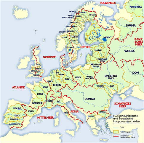
Deutsch: Grafik zeigt die Europäischen Flusseinzugsgebiete und Hauptwasserscheiden.
Zeichnung erstellt 06/2004 von Sansculotte. Bild ist unter der Creative Commons Share Alike zur weiteren Verwendung freigegeben.
Quellenangabe und Beleg an sansculotte@despammed.com erbeten.
English: The map shows the European rivers' catchment areas and main watersheds.
Chart made on 06/2004 by de:Sansculotte. The image is released under the Creative Commons Share Alike license for futher use.
Reference and sources can be requested from sansculotte@despammed.com
Français : Carte des bassins fluviaux d'Europe. Carte établie en juin 2004 par le contributeur de:Sansculotte
Sources (!) disponibles par demande à sansculotte@despammed.com
Fluß = River = Fleuve
Flußeinzugsgebiet = River drainage basin = Bassin fluvial
Europäische Hauptwassercheide = European main drainage divides (GB: watersheds)
Tarix
Mənbə
Source: German Wikipedia, original upload see file history
Müəllif
Sansculotte
İcazə (Faylın təkrar istifadəsi)
This file is licensed under the Creative Commons Attribution-Share Alike 2.0 Generic license.
Azadsınız:
paylaşmaq – əsəri köçürmək, paylamaq və ötürmək üçün
remiks etmək – əsəri adaptasiya etmək
Aşağıdakı şərtlərə riayət etməklə:
istinad – Müvafiq kredit verməlisiniz, lisenziyaya bir keçid verməlisiniz və dəyişikliklərin olub olmadığını bildirməlisiniz. Bunu hər hansı bir ağlabatan şəkildə edə bilərsiniz, ancaq lisenziyalaşdırıcının sizi və ya istifadənizi təsdiqləməsini təklif edən bir şəkildə deyil.
bənzər paylaşma – Əsəri remix edirsinizsə, dəyişdirirsinizsə və ya üzərində iş aparırsınızsa, öz töhfələrinizi orijinalda olduğu kimi eyni və ya uyğun lisenziya altında yayımlamalısınız.
Bu sənədi GNU Azad Sənədləşdirmə Lisenziyası, Versiya 1.2 və ya Azad Proqram Fondu tərəfindən nəşr olunan hər hansı sonrakı versiya şərtlərinə əsasən dəyişməz bölmələr, ön qapaq mətnləri və arxa qapaq mətnləri olmadan köçürmək, yayımlamaq və / və ya dəyişdirmək üçün icazə verilir; Lisenziyanın bir nüsxəsi GNU Azad Sənədləşdirmə Lisenziyası adlı hissəyə daxil edilmişdir.http://www.gnu.org/copyleft/fdl.htmlGFDLGNU Free Documentation Licensetruetrue
Bu fayl Creative Commons Attribution-Share Alike 3.0 Sinqapur lisenziyası altında yayımlanır.
Azadsınız:
paylaşmaq – əsəri köçürmək, paylamaq və ötürmək üçün
remiks etmək – əsəri adaptasiya etmək
Aşağıdakı şərtlərə riayət etməklə:
istinad – Müvafiq kredit verməlisiniz, lisenziyaya bir keçid verməlisiniz və dəyişikliklərin olub olmadığını bildirməlisiniz. Bunu hər hansı bir ağlabatan şəkildə edə bilərsiniz, ancaq lisenziyalaşdırıcının sizi və ya istifadənizi təsdiqləməsini təklif edən bir şəkildə deyil.
bənzər paylaşma – Əsəri remix edirsinizsə, dəyişdirirsinizsə və ya üzərində iş aparırsınızsa, öz töhfələrinizi orijinalda olduğu kimi eyni və ya uyğun lisenziya altında yayımlamalısınız.
This licensing tag was added to this file as part of the GFDL licensing update.http://creativecommons.org/licenses/by-sa/3.0/CC BY-SA 3.0Creative Commons Attribution-Share Alike 3.0truetrue
Digər versiyalar
Derivative works of this file:
Lignedepartagedeseaux.png:
Europäische Wasserscheiden - Zoom auf Pass Lunghin.png:
Europäische Wasserscheiden Danube.png:
Euroopa veelahkmed.png:
Europäische-Wasserscheiden-NO.jpg:
Main chain of the Alps.jpg:
Wasserscheide Nordsee Ostsee.PNG:
Lignedepartagedeseaux.png:
This geology image could be re-created using vector graphics as an SVG file. This has several advantages; see Commons:Media for cleanup for more information. If an SVG form of this image is available, please upload it and afterwards replace this template with {{vector version available|new image name}}. It is recommended to name the SVG file "Europäische Wasserscheiden.svg" – then the template Vector version available (or Vva) does not need the new image name parameter.
This is a featured picture on the alman language Wikipedia (Exzellente Bilder) and is considered one of the finest images.
If you think this file should be featured on Wikimedia Commons as well, feel free to nominate it. If you have an image of similar quality that can be published under a suitable copyright license, be sure to upload it, tag it, and nominate it.
File history German Wikipedia
(Löschen) (Aktuell) 16:54, 15. Jan 2005 . . Sansculotte . . 1200x1184 (602233 Byte) (korr.) (Löschen) (Zurücksetzen) 05:01, 3. Jun 2004 . . Sansculotte . . 1000x987 (262710 Byte) (eigene Darstellung, GNU FDL, Europäische Flußeinzugsgebiete und Hauptwasserscheiden) (Löschen) (Zurücksetzen) 04:21, 3. Jun 2004 . . Sansculotte . . 1000x987 (183238 Byte) (eigene Darstellung, GNU FDL, Europäische Flußeinzugsgebiete und Hauptwasserscheiden)
Captions
Add a one-line explanation of what this file represents
The main rivers of Europe and their catchment areas.
Items portrayed in this file
təsvir edir
Avropa
copyright status ingilis
copyrighted ingilis
lisenziya
GNU Free Documentation License, version 1.2 or later ingilis
Creative Commons Attribution-ShareAlike 2.0 Generic ingilis
Creative Commons Attribution-ShareAlike 3.0 Unported ingilis
yaranma tarixi
3 iyun 2004
MIME type ingilis
image/png
Faylın tarixçəsi
Faylın əvvəlki versiyasını görmək üçün gün/tarix bölməsindəki tarixlərə klikləyin.
(ən yeni | ən əvvəlki) Göstər (10 daha yeni) (10 daha köhnə) (10 | 20 | 50 | 100 | 250 | 500).
- Klare Farben für klar eInformationen - Ladogasee und finnische Flüsse nachgetragen - Wasser aus den Kattegat-Zuflüssen fließt nicht in die Ostsee; Zuordnung des Kattegat zur Ostsee nautisch und mangels eigener Meereseinheit
Drainage divide in Italy, Denmark, UK and Gibraltar corrected. By the way: If someone have time and a better map than me, the doted line in Finnland should be replaced by "full line".
fayl, europäische, wasserscheiden, fayl, faylın, tarixçəsi, fayl, keçidləri, faylın, qlobal, istifadəsisınaq, göstərişi, ölçüsü, piksel, digər, ölçülər, piksel, piksel, piksel, piksel, faylın, orijinalı, 8206, piksel, fayl, həcmi, mime, növü, image, fayl, viki. Fayl Faylin tarixcesi Fayl kecidleri Faylin qlobal istifadesiSinaq gosterisi olcusu 608 600 piksel Diger olculer 243 240 piksel 486 480 piksel 778 768 piksel 1 200 1 184 piksel Faylin orijinali 8206 1 200 1 184 piksel fayl hecmi 526 KB MIME novu image png Bu fayl Vikimedia Commons dadirve diger layihelerde istifade edile biler Faylin tesvir sehifesine get Xulase IzahEuropaische Wasserscheiden png Deutsch Grafik zeigt die Europaischen Flusseinzugsgebiete und Hauptwasserscheiden Zeichnung erstellt 06 2004 von Sansculotte Bild ist unter der Creative Commons Share Alike zur weiteren Verwendung freigegeben Quellenangabe und Beleg an sansculotte despammed com erbeten English The map shows the European rivers catchment areas and main watersheds Chart made on 06 2004 by de Sansculotte The image is released under the Creative Commons Share Alike license for futher use Reference and sources can be requested from sansculotte despammed com Francais nbsp Carte des bassins fluviaux d Europe Carte etablie en juin 2004 par le contributeur de Sansculotte Sources disponibles par demande a sansculotte despammed com Fluss River Fleuve Flusseinzugsgebiet River drainage basin Bassin fluvial Europaische Hauptwassercheide European main drainage divides GB watersheds Tarix 3 iyun 2004 Menbe Source German Wikipedia original upload see file history Muellif Sansculotte Icaze Faylin tekrar istifadesi This file is licensed under the Creative Commons Attribution Share Alike 2 0 Generic license Azadsiniz paylasmaq eseri kocurmek paylamaq ve oturmek ucun remiks etmek eseri adaptasiya etmek Asagidaki sertlere riayet etmekle istinad Muvafiq kredit vermelisiniz lisenziyaya bir kecid vermelisiniz ve deyisikliklerin olub olmadigini bildirmelisiniz Bunu her hansi bir aglabatan sekilde ede bilersiniz ancaq lisenziyalasdiricinin sizi ve ya istifadenizi tesdiqlemesini teklif eden bir sekilde deyil benzer paylasma Eseri remix edirsinizse deyisdirirsinizse ve ya uzerinde is aparirsinizsa oz tohfelerinizi orijinalda oldugu kimi eyni ve ya uygun lisenziya altinda yayimlamalisiniz https creativecommons org licenses by sa 2 0 CC BY SA 2 0 Creative Commons Attribution Share Alike 2 0 true true Bu senedi GNU Azad Senedlesdirme Lisenziyasi Versiya 1 2 ve ya Azad Proqram Fondu terefinden nesr olunan her hansi sonraki versiya sertlerine esasen deyismez bolmeler on qapaq metnleri ve arxa qapaq metnleri olmadan kocurmek yayimlamaq ve ve ya deyisdirmek ucun icaze verilir Lisenziyanin bir nusxesi GNU Azad Senedlesdirme Lisenziyasi adli hisseye daxil edilmisdir http www gnu org copyleft fdl html GFDL GNU Free Documentation License true true Bu fayl Creative Commons Attribution Share Alike 3 0 Sinqapur lisenziyasi altinda yayimlanir Azadsiniz paylasmaq eseri kocurmek paylamaq ve oturmek ucun remiks etmek eseri adaptasiya etmek Asagidaki sertlere riayet etmekle istinad Muvafiq kredit vermelisiniz lisenziyaya bir kecid vermelisiniz ve deyisikliklerin olub olmadigini bildirmelisiniz Bunu her hansi bir aglabatan sekilde ede bilersiniz ancaq lisenziyalasdiricinin sizi ve ya istifadenizi tesdiqlemesini teklif eden bir sekilde deyil benzer paylasma Eseri remix edirsinizse deyisdirirsinizse ve ya uzerinde is aparirsinizsa oz tohfelerinizi orijinalda oldugu kimi eyni ve ya uygun lisenziya altinda yayimlamalisiniz This licensing tag was added to this file as part of the GFDL licensing update http creativecommons org licenses by sa 3 0 CC BY SA 3 0 Creative Commons Attribution Share Alike 3 0 true true Diger versiyalar Derivative works of this file Lignedepartagedeseaux png nbsp Europaische Wasserscheiden Zoom auf Pass Lunghin png nbsp Europaische Wasserscheiden Danube png nbsp Euroopa veelahkmed png nbsp Europaische Wasserscheiden NO jpg nbsp Main chain of the Alps jpg nbsp Wasserscheide Nordsee Ostsee PNG nbsp Lignedepartagedeseaux png nbsp This geology image could be re created using vector graphics as an SVG file This has several advantages see nbsp Commons Media for cleanup for more information If nbsp an nbsp SVG nbsp form nbsp of nbsp this nbsp image is available please upload it and afterwards replace this template with vector version available i new image name i It is recommended to name the SVG file Europaische Wasserscheiden svg then the template Vector version available or Vva does not need the new image name parameter nbsp This is a featured picture on the alman language Wikipedia Exzellente Bilder and is considered one of the finest images If you think this file should be featured on Wikimedia Commons as well feel free to nominate it If you have an image of similar quality that can be published under a suitable copyright license be sure to upload it tag it and nominate it File history German Wikipedia Loschen Aktuell 16 54 15 Jan 2005 Sansculotte 1200x1184 602233 Byte korr Loschen Zurucksetzen 05 01 3 Jun 2004 Sansculotte 1000x987 262710 Byte eigene Darstellung GNU FDL Europaische Flusseinzugsgebiete und Hauptwasserscheiden Loschen Zurucksetzen 04 21 3 Jun 2004 Sansculotte 1000x987 183238 Byte eigene Darstellung GNU FDL Europaische Flusseinzugsgebiete und Hauptwasserscheiden CaptionsazerbaycancaAdd a one line explanation of what this file representsingilisThe main rivers of Europe and their catchment areas Items portrayed in this filetesvir edirAvropacopyright status nbsp ingiliscopyrighted nbsp ingilislisenziyaGNU Free Documentation License version 1 2 or later nbsp ingilisCreative Commons Attribution ShareAlike 2 0 Generic nbsp ingilisCreative Commons Attribution ShareAlike 3 0 Unported nbsp ingilisyaranma tarixi3 iyun 2004MIME type nbsp ingilisimage png Faylin tarixcesi Faylin evvelki versiyasini gormek ucun gun tarix bolmesindeki tarixlere klikleyin en yeni en evvelki Goster 10 daha yeni 10 daha kohne 10 20 50 100 250 500 Tarix VaxtKicik sekilOlculerIstifadeciSerh indiki08 45 31 iyul 20191 200 1 184 526 KB 1970geminientschleiert 01 21 16 may 20161 200 1 184 279 KB Ulamm Klare Farben fur klar eInformationen Ladogasee und finnische Flusse nachgetragen Wasser aus den Kattegat Zuflussen fliesst nicht in die Ostsee Zuordnung des Kattegat zur Ostsee nautisch und mangels eigener Meereseinheit 22 03 16 yanvar 20161 200 1 184 766 KB Francis McLloydGrenzen in Sudschweden im Osten von Danemark und westliche Ostsee erganzt jetzt 21 59 16 yanvar 20161 200 1 184 763 KB Francis McLloydGrenzen in Sudschweden im Osten von Danemark und westliche Ostsee erganzt 20 21 16 yanvar 20161 200 1 184 760 KB Francis McLloydGrenze im Nord Osten zwischen Newa und Kemijoki verbessert Gebiete westlich des Newas hinzugefugt 19 12 11 mart 20111 200 1 184 723 KB W like wikia small part of the Adria Mittelmeer drainage was missing But i don t have time to check exactly thats why only doted line 18 14 11 mart 20111 200 1 184 724 KB W like wikiDrainage divide in Italy Denmark UK and Gibraltar corrected By the way If someone have time and a better map than me the doted line in Finnland should be replaced by full line 13 59 7 yanvar 20111 200 1 184 849 KB CareSaimaa fix 14 44 24 fevral 20101 200 1 184 564 KB DcoetzeeRemove watermark pngcrush 19 26 2 iyul 20091 200 1 184 552 KB NordNordWestDanube corrected plus names of Vardar and Mariza en yeni en evvelki Goster 10 daha yeni 10 daha kohne 10 20 50 100 250 500 Fayl kecidleri Bu sekile olan kecidler Axar baxar Faylin qlobal istifadesi Bu fayl asagidaki vikilerde istifade olunur af wikipedia org layihesinde istifadesi Waterskeiding als wikipedia org layihesinde istifadesi Einzugsgebiet Hydrologie Wasserscheide ar wikipedia org layihesinde istifadesi حد التصريف قائمة أنهار أوروبا arz wikipedia org layihesinde istifadesi انهار اوروبا ba wikipedia org layihesinde istifadesi Һyu ajyrgys be tarask wikipedia org layihesinde istifadesi Vodapadzel be wikipedia org layihesinde istifadesi Vodapadzel bg wikipedia org layihesinde istifadesi Rejn Vododel Spisk na rekite v Evropa vodosboren basejn na Atlanticheskiya okean Spisk na rekite v Evropa vodosboren basejn na Severniya ledovit okean Spisk na rekite v Evropa vodosborni basejni na bezottochnite oblasti bs wikipedia org layihesinde istifadesi Spisak rijeka u Evropi ceb wikipedia org layihesinde istifadesi Tubig saluran cs wikipedia org layihesinde istifadesi Dunaj Povodi Rozvodi Geografie Ceska Geografie Srbska Geografie Chorvatska da wikipedia org layihesinde istifadesi Europaeiske floder Lviv Europaeiske vandskel de wikipedia org layihesinde istifadesi Donau Niedersachsen Ostsee Rhein Elbe Lubeck Kanal Wasserscheide Liste von Flussen in Europa Dietweis Wikipedia Kandidaten fur exzellente Bilder Archiv2005 1 Wasserscheiden in den Alpen Benutzer Alopex Tipps Portal Diskussion Geographie Bild des Monats Einzugsgebiet Geographie Europas Wikipedia Exzellente Bilder Karten und Satellitenbilder Diskussion Schartenhohe Europaische Hauptwasserscheide Benutzer NatiSythen Karten Benutzer WA1TF0R Galerie Benutzer Mikullovci11 Work Karten Wikipedia Kartenwerkstatt Benutzer Wesn todo Benutzer Diskussion Watzmann Archiv 2013 Lichtenstein Gemeinde Schenkenfelden Datei Europaische Wasserscheiden png Bu faylin qlobal istifadesine baxin Menbe https az wikipedia org wiki Fayl Europaische Wasserscheiden png, wikipedia, oxu, kitab, kitabxana, axtar, tap, hersey,
ne axtarsan burda
, en yaxsi meqale sayti, meqaleler, kitablar, oyrenmek, wiki, bilgi, tarix, seks, porno, indir, yukle, sex, azeri sex, azeri, seks yukle, sex yukle, izle, seks izle, porno izle, mobil seks, telefon ucun, chat, azeri chat, tanisliq, tanishliq, azeri tanishliq, sayt, medeni, medeni saytlar, chatlar, mekan, tanisliq mekani, mekanlari, yüklə, pulsuz, pulsuz yüklə, mp3, video, mp4, 3gp, jpg, jpeg, gif, png, şəkil, muisiqi, mahnı, kino, film, kitab, oyun, oyunlar.