Bu fayl "Vikimedia Commons"dadır və digər layihələrdə istifadə edilə bilər.
Faylın təsvir səhifəsinə get
Xülasə
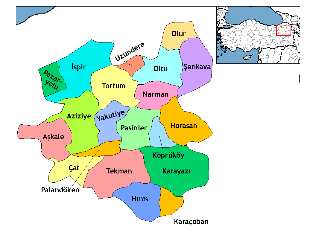
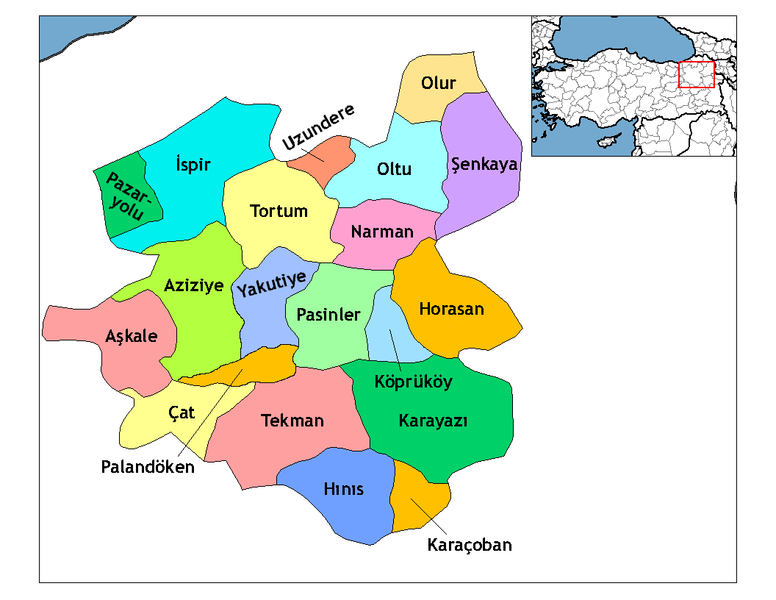
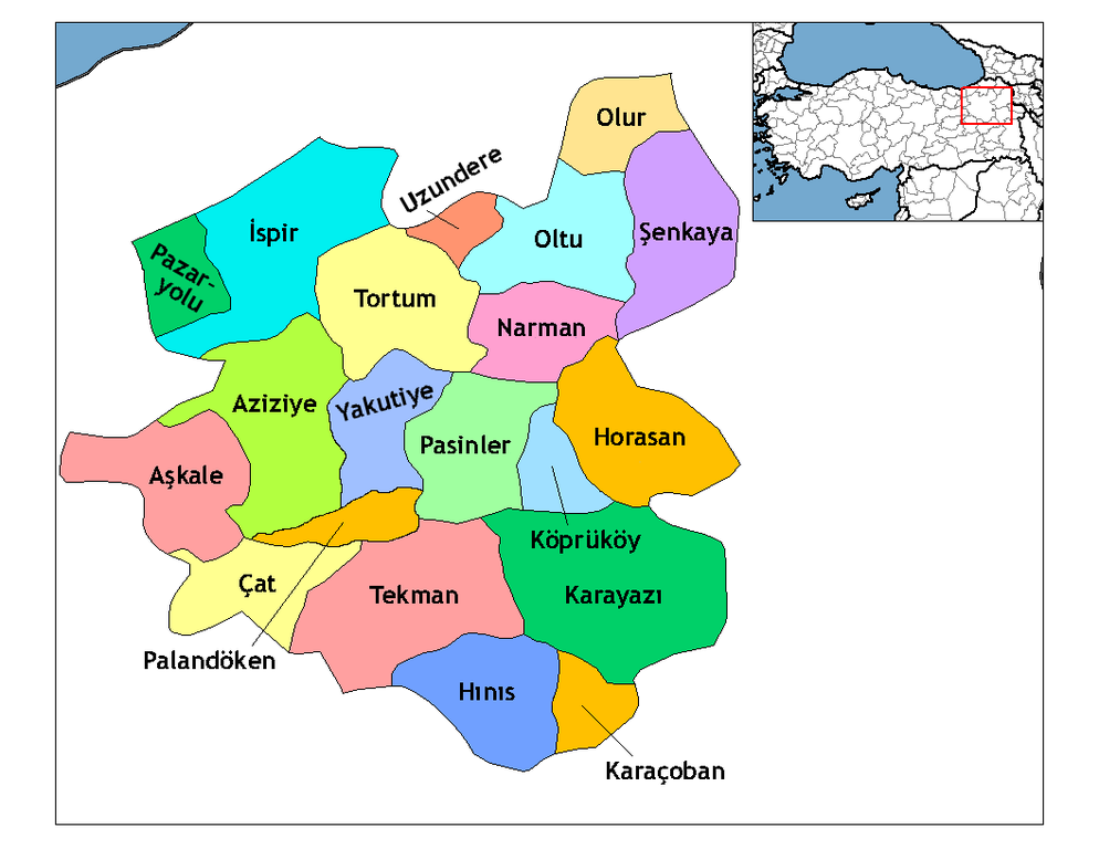
İzahErzurum districts.png
Map of the districts of Erzurum province in Turkey. Created by Rarelibra 19:53, 1 December 2006 (UTC) for public domain use, using MapInfo Professional v8.5 and various mapping resources. Edited by One Homo Sapiens Corrected text where İ,Ş,ı,ğ,or ş occurs in name. Source: [statoids-com]. Increased font size and enhanced color differences among adjacent districts.
Tarix
1 dekabr 2006 (original upload date)
Mənbə
No machine-readable source provided. Own work assumed (based on copyright claims).
Müəllif
No machine-readable author provided. Rarelibra assumed (based on copyright claims).
Lisenziya
Public domainPublic domainfalsefalse
Captions
Add a one-line explanation of what this file represents
Erzurum siyasi haritası
Items portrayed in this file
təsvir edir
copyright status ingilis
copyrighted, dedicated to the public domain by copyright holder ingilis
lisenziya
released into the public domain by the copyright holder ingilis
yaranma tarixi
1 dekabr 2006
Faylın tarixçəsi
Faylın əvvəlki versiyasını görmək üçün gün/tarix bölməsindəki tarixlərə klikləyin.
Map of the districts of Erzurum province in Turkey. Created by ~~~~ for public domain use, using MapInfo Professional v8.5 and various mapping resources.
Fayl keçidləri
Bu faylı istifadə edən səhifə yoxdur.
Faylın qlobal istifadəsi
Bu fayl aşağıdakı vikilərdə istifadə olunur:
هوراسان
ازونديرى
كوبروكوى
باسينلر
ارزروم اوستانی
Erzurum (pokrajina)
Karaçoban
Hınıs
Karayazı
Köprüköy
Tekman
Aşkale
Oltu
Pasinler
İspir
Vorlage:Navigationsleiste Landkreise der Provinz Erzurum
fayl, erzurum, districts, fayl, faylın, tarixçəsi, fayl, keçidləri, faylın, qlobal, istifadəsisınaq, göstərişi, ölçüsü, piksel, digər, ölçülər, piksel, piksel, piksel, piksel, faylın, orijinalı, 8206, piksel, fayl, həcmi, mime, növü, image, fayl, vikimedia, co. Fayl Faylin tarixcesi Fayl kecidleri Faylin qlobal istifadesiSinaq gosterisi olcusu 776 600 piksel Diger olculer 311 240 piksel 621 480 piksel 994 768 piksel 1 056 816 piksel Faylin orijinali 8206 1 056 816 piksel fayl hecmi 38 KB MIME novu image png Bu fayl Vikimedia Commons dadirve diger layihelerde istifade edile biler Faylin tesvir sehifesine get Xulase IzahErzurum districts png Map of the districts of Erzurum province in Turkey Created by Rarelibra 19 53 1 December 2006 UTC for public domain use using MapInfo Professional v8 5 and various mapping resources Edited by One Homo Sapiens Corrected text where I S i g or s occurs in name Source statoids com Increased font size and enhanced color differences among adjacent districts Tarix 1 dekabr 2006 original upload date Menbe No machine readable source provided Own work assumed based on copyright claims Muellif No machine readable author provided Rarelibra assumed based on copyright claims Lisenziya Public domain Public domain false false Men bu eserin muellif huquqlarinin sahibi kimi eseri ictimai mulkiyyete verirem Bu icaze butun dunyada quvvededir In some countries this may not be legally possible if so Bunun qanunla mumkun olmadigi hallarda Istenilen sexse istenilen meqsed ucun qanunlar terefinden qadagan edilmeyince hec bir sert qoymadan bu isden istifade haqqini bagislayiram CaptionsazerbaycancaAdd a one line explanation of what this file representsturkErzurum siyasi haritasiItems portrayed in this filetesvir edircopyright status nbsp ingiliscopyrighted dedicated to the public domain by copyright holder nbsp ingilislisenziyareleased into the public domain by the copyright holder nbsp ingilisyaranma tarixi1 dekabr 2006 Faylin tarixcesi Faylin evvelki versiyasini gormek ucun gun tarix bolmesindeki tarixlere klikleyin Tarix VaxtKicik sekilOlculerIstifadeciSerh indiki02 52 18 aprel 20091 056 816 38 KB One Homo SapiensAdded Aziziye Palandoken and Yakutiye that replaced Erzurum merkezi and Ilica districts Source lt lt www erzurum gov tr gt gt 22 20 28 dekabr 20081 056 816 41 KB One Homo SapiensCorrected text where I S i g or s occurs in name Source statoids com Increased font size and enhanced color differences among adjacent districts 19 53 1 dekabr 20061 056 816 35 KB RarelibraMap of the districts of Erzurum province in Turkey Created by for public domain use using MapInfo Professional v8 5 and various mapping resources Fayl kecidleri Bu fayli istifade eden sehife yoxdur Faylin qlobal istifadesi Bu fayl asagidaki vikilerde istifade olunur ar wikipedia org layihesinde istifadesi كوبروكوي هوراسان arz wikipedia org layihesinde istifadesi سينكايا ازونديرى كوبروكوى باسينلر ast wikipedia org layihesinde istifadesi Distritos de Turquia azb wikipedia org layihesinde istifadesi پاسینلر ارزروم اوستانی ba wikipedia org layihesinde istifadesi Әrzurum provinciya bs wikipedia org layihesinde istifadesi Horasan grad Erzurum pokrajina ca wikipedia org layihesinde istifadesi Districtes de Turquia cbk zam wikipedia org layihesinde istifadesi Regiones de Turquia cs wikipedia org layihesinde istifadesi Erzurum provincie de wikipedia org layihesinde istifadesi Erzurum Karacoban Hinis Karayazi Koprukoy Tekman Askale Oltu Pasinler Ispir Vorlage Navigationsleiste Landkreise der Provinz Erzurum Uzundere Tortum Senkaya Pazaryolu Olur Narman Horasan Cat Aziziye Yakutiye Palandoken Erzurum diq wikipedia org layihesinde istifadesi Xinis Qeze Tirkiya en wikipedia org layihesinde istifadesi Erzurum Province Erzurum Askale Hinis Horasan Ispir Karacoban Karayazi Koprukoy Oltu Pazaryolu Bu faylin qlobal istifadesine baxin Menbe https az wikipedia org wiki Fayl Erzurum districts png, wikipedia, oxu, kitab, kitabxana, axtar, tap, hersey,
ne axtarsan burda
, en yaxsi meqale sayti, meqaleler, kitablar, oyrenmek, wiki, bilgi, tarix, seks, porno, indir, yukle, sex, azeri sex, azeri, seks yukle, sex yukle, izle, seks izle, porno izle, mobil seks, telefon ucun, chat, azeri chat, tanisliq, tanishliq, azeri tanishliq, sayt, medeni, medeni saytlar, chatlar, mekan, tanisliq mekani, mekanlari, yüklə, pulsuz, pulsuz yüklə, mp3, video, mp4, 3gp, jpg, jpeg, gif, png, şəkil, muisiqi, mahnı, kino, film, kitab, oyun, oyunlar.