Bu fayl "Vikimedia Commons"dadır və digər layihələrdə istifadə edilə bilər.
Faylın təsvir səhifəsinə get
Pp
Xülasə
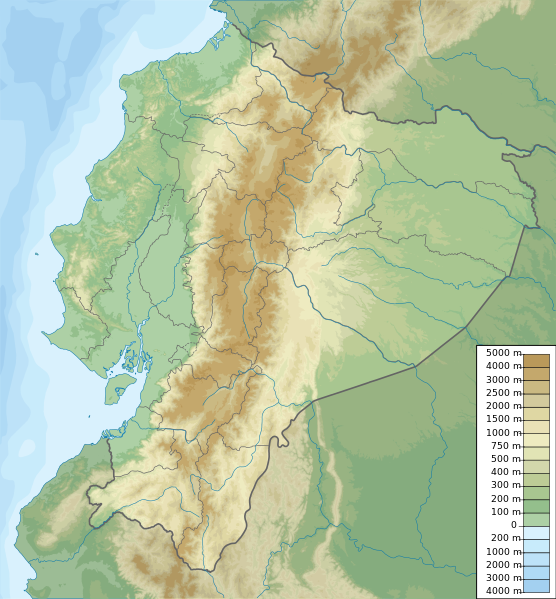
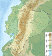
İzahEcuador relief location map.svg
Ecuador physical map, parameters equal to File:Ecuador location map.svg
Tarix
Mənbə
Öz işi
Müəllif
Urutseg
Lisenziya
I, the copyright holder of this work, hereby publish it under the following license:
This file is made available under the Creative Commons CC0 1.0 Universal Public Domain Dedication.
The person who associated a work with this deed has dedicated the work to the public domain by waiving all of their rights to the work worldwide under copyright law, including all related and neighboring rights, to the extent allowed by law. You can copy, modify, distribute and perform the work, even for commercial purposes, all without asking permission.
http://creativecommons.org/publicdomain/zero/1.0/deed.enCC0Creative Commons Zero, Public Domain Dedicationfalsefalse
Captions
Add a one-line explanation of what this file represents
Items portrayed in this file
təsvir edir
copyright status ingilis
copyrighted, dedicated to the public domain by copyright holder ingilis
lisenziya
CC0 ingilis
yaranma tarixi
14 mart 2014
source of file ingilis
original creation by uploader ingilis
Faylın tarixçəsi
Faylın əvvəlki versiyasını görmək üçün gün/tarix bölməsindəki tarixlərə klikləyin.
Bu faylda fotoaparat və ya skanerlə əlavə olunmuş məlumatlar var. Əgər fayl sonradan redaktə olunubsa, bəzi parametrlər bu şəkildə göstərilənlərdən fərqli ola bilər.
Genişlik
851.281px
Hündürlük
916.8px
Yanvar 13, 2023
fayl, ecuador, relief, location, fayl, faylın, tarixçəsi, istifadə, edilən, səhifələr, faylın, qlobal, istifadəsi, metaməlumatlarbu, faylın, formatındakı, görünüşünün, ölçüsü, piksel, digər, ölçülər, piksel, piksel, piksel, piksel, piksel, piksel, faylın, orij. Fayl Faylin tarixcesi Istifade edilen sehifeler Faylin qlobal istifadesi MetamelumatlarBu SVG faylin PNG formatindaki bu gorunusunun olcusu 556 599 piksel Diger olculer 223 240 piksel 445 480 piksel 713 768 piksel 950 1 024 piksel 1 901 2 048 piksel 851 917 piksel Faylin orijinali 8206 SVG fayli nominal olaraq 851 917 piksel faylin olcusu 3 76 MB Bu fayl Vikimedia Commons dadirve diger layihelerde istifade edile biler Faylin tesvir sehifesine get Pp Xulase IzahEcuador relief location map svg Ecuador physical map parameters equal to File Ecuador location map svgTarix 14 mart 2014Menbe Oz isiMuellif Urutseg Lisenziya I the copyright holder of this work hereby publish it under the following license This file is made available under the Creative Commons CC0 1 0 Universal Public Domain Dedication The person who associated a work with this deed has dedicated the work to the public domain by waiving all of their rights to the work worldwide under copyright law including all related and neighboring rights to the extent allowed by law You can copy modify distribute and perform the work even for commercial purposes all without asking permission http creativecommons org publicdomain zero 1 0 deed en CC0 Creative Commons Zero Public Domain Dedication false falseCaptionsazerbaycancaAdd a one line explanation of what this file representsItems portrayed in this filetesvir edircopyright status ingiliscopyrighted dedicated to the public domain by copyright holder ingilislisenziyaCC0 ingilisyaranma tarixi14 mart 2014source of file ingilisoriginal creation by uploader ingilis Faylin tarixcesi Faylin evvelki versiyasini gormek ucun gun tarix bolmesindeki tarixlere klikleyin Tarix VaxtKicik sekilOlculerIstifadeciSerh indiki19 49 15 oktyabr 2012851 917 3 76 MB Milenioscurocorrections of coastal line and boundaries according to Ecuador location map svg 15 16 26 avqust 20121 536 1 654 2 49 MB Joffrenomuereson 24 Provincias no 22 08 04 15 iyun 2012851 917 2 13 MB TUBSrv please follow map conventions cf your disk 18 53 13 iyun 2012851 917 2 35 MB Joffrenomuere24 provincias 19 00 14 mart 2011851 917 2 13 MB Urutseg Istifade edilen sehifeler Bu sekile olan kecidler Tunquraua Cimbaroso vulkani Sablon Yer xeritesi Ekvador Faylin qlobal istifadesi Bu fayl asagidaki vikilerde istifade olunur ar wikipedia org layihesinde istifadesi قالب خريطة مواقع الإكوادور ast wikipedia org layihesinde istifadesi Xeografia d Ecuador Modulu Minimapa data Ecuador Modulu Minimapa data Ecuador usu azb wikipedia org layihesinde istifadesi اکوادور کیتو ban wikipedia org layihesinde istifadesi Taman Nasional Sangay Taman Nasional El Cajas Taman Nasional Cotopaxi Taman Nasional Llanganates Taman Nasional Machalilla Taman Nasional Podocarpus Taman Nasional Yacuri Taman Nasional Cotacachi Cayapas Taman Nasional Rio Negro Sopladora be wikipedia org layihesinde istifadesi Katapahi Chymbarasa Shablon Na karce Ekvador Guayas Sangaj Putumayo Galapagaski marski zapavednik Isla De La Plata Puna vostray bg wikipedia org layihesinde istifadesi Chimboraso Kito Kotopaksi Guayakil Shablon PK Ekvador Tunguraua bh wikipedia org layihesinde istifadesi च ब र ज Module Location map data Ecuador Module Location map data Ecuador doc bn wikipedia org layihesinde istifadesi ১৭৯৭ র ওব ম ব ভ ম কম প মড উল অবস থ ন ম নচ ত র উপ ত ত ইক য ডর মড উল অবস থ ন ম নচ ত র উপ ত ত ইক য ডর নথ ক ত গ য ইয ক ল bs wikipedia org layihesinde istifadesi Chimborazo Cotopaxi Pichincha vulkan Sablon Lokacijska karta Ekvador Cayambe vulkan Reventador Antisana Illiniza Sablon Vulkani u Ekvadoru ca wikipedia org layihesinde istifadesi Modul Location map data Equador Modul Location map data Equador us ceb wikipedia org layihesinde istifadesi Atelopus onorei Bu faylin qlobal istifadesine baxin Metamelumatlar Bu faylda fotoaparat ve ya skanerle elave olunmus melumatlar var Eger fayl sonradan redakte olunubsa bezi parametrler bu sekilde gosterilenlerden ferqli ola biler Genislik851 281pxHundurluk916 8px Menbe https az wikipedia org wiki Fayl Ecuador relief location map svg, wikipedia, oxu, kitab, kitabxana, axtar, tap, hersey,
ne axtarsan burda
, en yaxsi meqale sayti, meqaleler, kitablar, oyrenmek, wiki, bilgi, tarix, seks, porno, indir, yukle, sex, azeri sex, azeri, seks yukle, sex yukle, izle, seks izle, porno izle, mobil seks, telefon ucun, chat, azeri chat, tanisliq, tanishliq, azeri tanishliq, sayt, medeni, medeni saytlar, chatlar, mekan, tanisliq mekani, mekanlari, yüklə, pulsuz, pulsuz yüklə, mp3, video, mp4, 3gp, jpg, jpeg, gif, png, şəkil, muisiqi, mahnı, kino, film, kitab, oyun, oyunlar.