This file was a candidate in Picture of the Year 2007. This is a featured picture on Wikimedia Commons (Featured pictures) and is considered one of the finest images.
If you have an image of similar quality that can be published under a suitable copyright license, be sure to upload it, tag it, and nominate it.
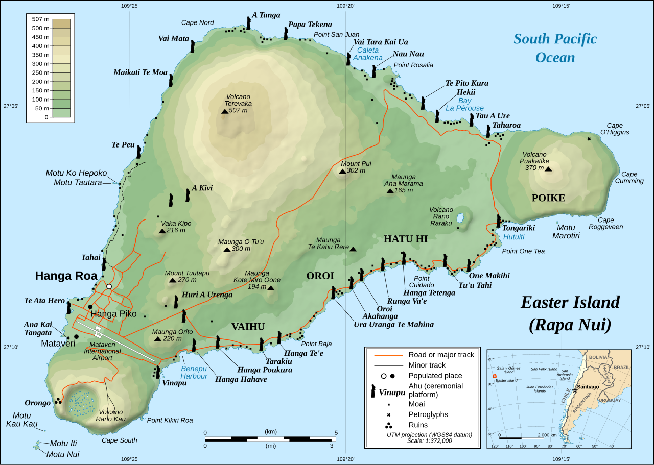
İzahEaster Island map-en.svg
English: Detailed topographic map in English of Easter Island
Français : Carte topographique détaillée en anglais de l'île de Paques
Português: Mapa topográfico detalhado, em Inglês, da Ilha da Páscoa.
UTM projection, WGS84 datum, shaded relief
Scale: 1:372,000 (precision: 93 m)
Tarix
October 2007 - October 2008 for the new version (see the release note)
Mənbə
Own work
Shorelines, ponds, roads, trails and airport drawn using Landsat 7 ETM+ imagery (public domain);
Topography: NASA Shuttle Radar Topography Mission (SRTM3v2) (public domain);
Main references used for the toponymy:
prof. William Mulloy's map (easier to read here);
Pacific Island Travel map (http://www.pacificislandtravel.com/easter_island/about_destin/isla_de_pascua[1].jpg);
Bu xəritə Qrafik emalatxanada (fr) yaradılmışdır. Siz həmçinin təsvirin yaxşılaşması ilə bağlı müraciət edə bilərsiniz.
This W3C-unspecified vector image was created with Inkscape .
This SVG file contains embedded text that can be translated into your language, using any capable SVG editor, text editor or the SVG Translate tool. For more information see: About translating SVG files.
Lisenziya
I, the copyright holder of this work, hereby publish it under the following license:
This file is licensed under the Creative Commons Attribution-Share Alike 2.5 Generic license.
Azadsınız:
paylaşmaq – əsəri köçürmək, paylamaq və ötürmək üçün
remiks etmək – əsəri adaptasiya etmək
Aşağıdakı şərtlərə riayət etməklə:
istinad – Müvafiq kredit verməlisiniz, lisenziyaya bir keçid verməlisiniz və dəyişikliklərin olub olmadığını bildirməlisiniz. Bunu hər hansı bir ağlabatan şəkildə edə bilərsiniz, ancaq lisenziyalaşdırıcının sizi və ya istifadənizi təsdiqləməsini təklif edən bir şəkildə deyil.
bənzər paylaşma – Əsəri remix edirsinizsə, dəyişdirirsinizsə və ya üzərində iş aparırsınızsa, öz töhfələrinizi orijinalda olduğu kimi eyni və ya uyğun lisenziya altında yayımlamalısınız.
{{Information |Description= |Source=self-made |Date= |Author= Bamse }} == Summary == {{Information| |Description=Detailed topographic map in English of Easter island |Source=Own work, translation of Image:Easter Island map-fr.svg<b
Bu faylda fotoaparat və ya skanerlə əlavə olunmuş məlumatlar var. Əgər fayl sonradan redaktə olunubsa, bəzi parametrlər bu şəkildə göstərilənlərdən fərqli ola bilər.
Genişlik
1750
Hündürlük
1245
May 10, 2023
fayl, easter, island, fayl, faylın, tarixçəsi, fayl, keçidləri, faylın, qlobal, istifadəsi, metaməlumatlarbu, faylın, formatındakı, görünüşünün, ölçüsü, piksel, digər, ölçülər, piksel, piksel, piksel, piksel, piksel, piksel, faylın, orijinalı, 8206, faylı, nom. Fayl Faylin tarixcesi Fayl kecidleri Faylin qlobal istifadesi MetamelumatlarBu SVG faylin PNG formatindaki bu gorunusunun olcusu 800 569 piksel Diger olculer 320 228 piksel 640 455 piksel 1 024 729 piksel 1 280 911 piksel 2 560 1 821 piksel 1 750 1 245 piksel Faylin orijinali 8206 SVG fayli nominal olaraq 1 750 1 245 piksel faylin olcusu 878 KB Bu fayl Vikimedia Commons dadirve diger layihelerde istifade edile biler Faylin tesvir sehifesine get Xulase This image was selected as picture of the day on Wikimedia Commons for 1 December 2008 It was captioned as follows English Detailed topographic map in English of Easter Island Other languages Afrikaans Gedetaileerde topografie van PaaseilandCatala Mapa topografic detallat en angles de l Illa de Pasqua Cestina Detailni topograficka mapa Velikonocniho ostrovaDansk Detaljeret topografisk kort over Paskeoen pa engelsk Deutsch Ubersichtskarte der Osterinsel deutsche Version hierEesti Detailne inglisekeelne topograafiline kaart et Lihavottesaarest English Detailed topographic map in English of Easter Island Espanol Mapa topografico detallado en ingles de la Isla de Pascua Chile Esperanto detala topografia mapo de la Paskinsulo jen anglalingva sed ankaŭ havebla en pluraj aliaj lingvoj Francais Carte topographique detaillee en anglais de l ile de PaquesItaliano Mappa topografica dell Isola di Pasqua Cile Magyar A Husvet sziget reszletes topografiai terkepeNederlands Engelstalige gedetailleerde topografische kaart van PaaseilandPolski Mapa topograficzna Wyspy WielkanocnejPortugues Mapa topografico detalhado em Ingles da Ilha da PascoaRomană Hartă topografică detaliată in limba engleză a insulei Paștelui Svenska Detaljerad topografisk karta pa engelska over Paskon Makedonski Detalna topografska karta na Veligdenskiot Ostrov na angliski Russkij Topograficheskaya karta Ostrova PashiUkrayinska Detalna anglomovna topografichna mapa Ostrovu Pashi 한국어 이스터 섬의 지형도 日本語 英語によるイースター島の詳細な地形図 中文 复活节岛地形图中文 繁體 復活節島地形圖 This file was a candidate in Picture of the Year 2007 This is a featured picture on Wikimedia Commons Featured pictures and is considered one of the finest images If you have an image of similar quality that can be published under a suitable copyright license be sure to upload it tag it and nominate it IzahEaster Island map en svg English Detailed topographic map in English of Easter Island Francais nbsp Carte topographique detaillee en anglais de l ile de Paques Portugues Mapa topografico detalhado em Ingles da Ilha da Pascoa UTM projection WGS84 datum shaded relief Scale 1 372 000 precision 93 m Tarix October 2007 October 2008 for the new version see the release note Menbe Own work Shorelines ponds roads trails and airport drawn using Landsat 7 ETM imagery public domain Topography NASA Shuttle Radar Topography Mission SRTM3v2 public domain Main references used for the toponymy prof William Mulloy s map easier to read here Pacific Island Travel map http www pacificislandtravel com easter island about destin isla de pascua 1 jpg 1 Muellif Eric Gaba Sting translated by Bamse Icaze Faylin tekrar istifadesi Creative Commons Share Alike attribution required Diger versiyalar redakte alman ingilis ispan fransiz original italyan gurcu macar makedon holland rus serb ukrayna Bu xerite Qrafik emalatxanada fr yaradilmisdir Siz hemcinin tesvirin yaxsilasmasi ile bagli muraciet ede bilersiniz nbsp This W3C unspecified vector image was created with Inkscape This SVG file contains embedded text that can be translated into your language using any capable SVG editor text editor or the SVG Translate tool For more information see About translating SVG files Lisenziya I the copyright holder of this work hereby publish it under the following license This file is licensed under the Creative Commons Attribution Share Alike 2 5 Generic license Azadsiniz paylasmaq eseri kocurmek paylamaq ve oturmek ucun remiks etmek eseri adaptasiya etmek Asagidaki sertlere riayet etmekle istinad Muvafiq kredit vermelisiniz lisenziyaya bir kecid vermelisiniz ve deyisikliklerin olub olmadigini bildirmelisiniz Bunu her hansi bir aglabatan sekilde ede bilersiniz ancaq lisenziyalasdiricinin sizi ve ya istifadenizi tesdiqlemesini teklif eden bir sekilde deyil benzer paylasma Eseri remix edirsinizse deyisdirirsinizse ve ya uzerinde is aparirsinizsa oz tohfelerinizi orijinalda oldugu kimi eyni ve ya uygun lisenziya altinda yayimlamalisiniz https creativecommons org licenses by sa 2 5 CC BY SA 2 5 Creative Commons Attribution Share Alike 2 5 true trueCaptionsazerbaycancaAdd a one line explanation of what this file representsItems portrayed in this filetesvir edircografi xeritecopyright status nbsp ingiliscopyrighted nbsp ingilislisenziyaCreative Commons Attribution ShareAlike 2 5 Generic nbsp ingilisCommons quality assessment nbsp ingilisWikimedia Commons featured picture nbsp ingilisMIME type nbsp ingilisimage svg xml Faylin tarixcesi Faylin evvelki versiyasini gormek ucun gun tarix bolmesindeki tarixlere klikleyin Tarix VaxtKicik sekilOlculerIstifadeciSerh indiki22 51 11 yanvar 20231 750 1 245 878 KB Tseng Lu YenReverted to version as of 12 43 22 October 2008 UTC 07 17 10 dekabr 20111 750 1 245 1 92 MB Hel hamaText appearance improved using Inkscape 12 43 22 oktyabr 20081 750 1 245 878 KB StingCompletely new version of the map new standard colors 01 06 30 oktyabr 20071 750 1 245 536 KB StingSome additional info 00 37 19 oktyabr 20071 750 1 245 534 KB Bamse 00 14 19 oktyabr 20071 750 1 245 534 KB Bamse Information Description Source self made Date Author Bamse Summary Information Description Detailed topographic map in English of Easter island Source Own work translation of Image Easter Island map fr svg lt b Fayl kecidleri Bu sekile olan kecidler Pasxa adasi Faylin qlobal istifadesi Bu fayl asagidaki vikilerde istifade olunur af wikipedia org layihesinde istifadesi Wikipedia Beeld van die week 2016 Wikipedia Voorbladbeeld week 3 2016 Moai ami wikipedia org layihesinde istifadesi Easter iland ar wikipedia org layihesinde istifadesi آهو تونغاريكي bcl wikipedia org layihesinde istifadesi Moai Isla nin Paskwa bn wikipedia org layihesinde istifadesi উইক প ড য আজক র ন র ব চ ত ছব ড স ম বর ২০০৮ ca wikipedia org layihesinde istifadesi Parc Nacional de Rapa Nui Terevaka ckb wikipedia org layihesinde istifadesi ئاھو تۆنگاریکی da wikipedia org layihesinde istifadesi Paskeoen de wikipedia org layihesinde istifadesi Maunga Terevaka el wikipedia org layihesinde istifadesi Nhsi toy Pasxa en wikipedia org layihesinde istifadesi Cartography Easter Island Hanga Roa Mu mythical lost continent Moai Motu Nui Map coloring Rapa Nui National Park Hanau epe Orongo Ahu Tongariki Poike Rano Kau Terevaka Ahu Akivi List of active separatist movements in Oceania User ISaveNewspapers sandbox Isla de Pascua commune Portal Geodesy en wikiversity org layihesinde istifadesi Honours thesis in psychology Honours thesis in psychology Developing a literature review en wikivoyage org layihesinde istifadesi Easter Island es wikipedia org layihesinde istifadesi Ninachumbi et wikipedia org layihesinde istifadesi Kartograafia Moaid fa wikipedia org layihesinde istifadesi جزیره ایستر هانگا روآ آهو تونگاریکی frr wikipedia org layihesinde istifadesi Poosche ailonj fr wikipedia org layihesinde istifadesi Utilisateur Sting Hanau epe ga wikipedia org layihesinde istifadesi Oilean na Casca gl wikipedia org layihesinde istifadesi Lingua rapanui Parque Nacional Rapa Nui gv wikipedia org layihesinde istifadesi Ellan y Chaisht haw wikipedia org layihesinde istifadesi Moʻai Bu faylin qlobal istifadesine baxin Metamelumatlar Bu faylda fotoaparat ve ya skanerle elave olunmus melumatlar var Eger fayl sonradan redakte olunubsa bezi parametrler bu sekilde gosterilenlerden ferqli ola biler Genislik1750Hundurluk1245 Menbe https az wikipedia org wiki Fayl Easter Island map en svg, wikipedia, oxu, kitab, kitabxana, axtar, tap, hersey,
ne axtarsan burda
, en yaxsi meqale sayti, meqaleler, kitablar, oyrenmek, wiki, bilgi, tarix, seks, porno, indir, yukle, sex, azeri sex, azeri, seks yukle, sex yukle, izle, seks izle, porno izle, mobil seks, telefon ucun, chat, azeri chat, tanisliq, tanishliq, azeri tanishliq, sayt, medeni, medeni saytlar, chatlar, mekan, tanisliq mekani, mekanlari, yüklə, pulsuz, pulsuz yüklə, mp3, video, mp4, 3gp, jpg, jpeg, gif, png, şəkil, muisiqi, mahnı, kino, film, kitab, oyun, oyunlar.
![[1]](http://www.waymarker.co.uk/ml/rapanui/map.jpg)