Bu fayl "Vikimedia Commons"dadır və digər layihələrdə istifadə edilə bilər.
təsvir səhifəsi
Faylın təsvir səhifəsinə get
This historical map image could be re-created using vector graphics as an SVG file. This has several advantages; see Commons:Media for cleanup for more information. If an SVG form of this image is available, please upload it and afterwards replace this template with {{vector version available|new image name}}. It is recommended to name the SVG file "East-Hem 1000bc.svg" – then the template Vector version available (or Vva) does not need the new image name parameter.
This historical map image was uploaded in the JPEG format even though it consists of non-photographic data. This information could be stored more efficiently or accurately in the PNG or SVG format. If possible, please upload a PNG or SVG version of this image without compression artifacts, derived from a non-JPEG source (or with existing artifacts removed). After doing so, please tag the JPEG version with {{Superseded|NewImage.ext}} and remove this tag. This tag should not be applied to photographs or scans. If this image is a diagram or other image suitable for vectorisation, please tag this image with {{Convert to SVG}} instead of {{BadJPEG}}. If not suitable for vectorisation, use {{Convert to PNG}}. For more information, see {{BadJPEG}}.
İzahEast-Hem 1000bc.jpg
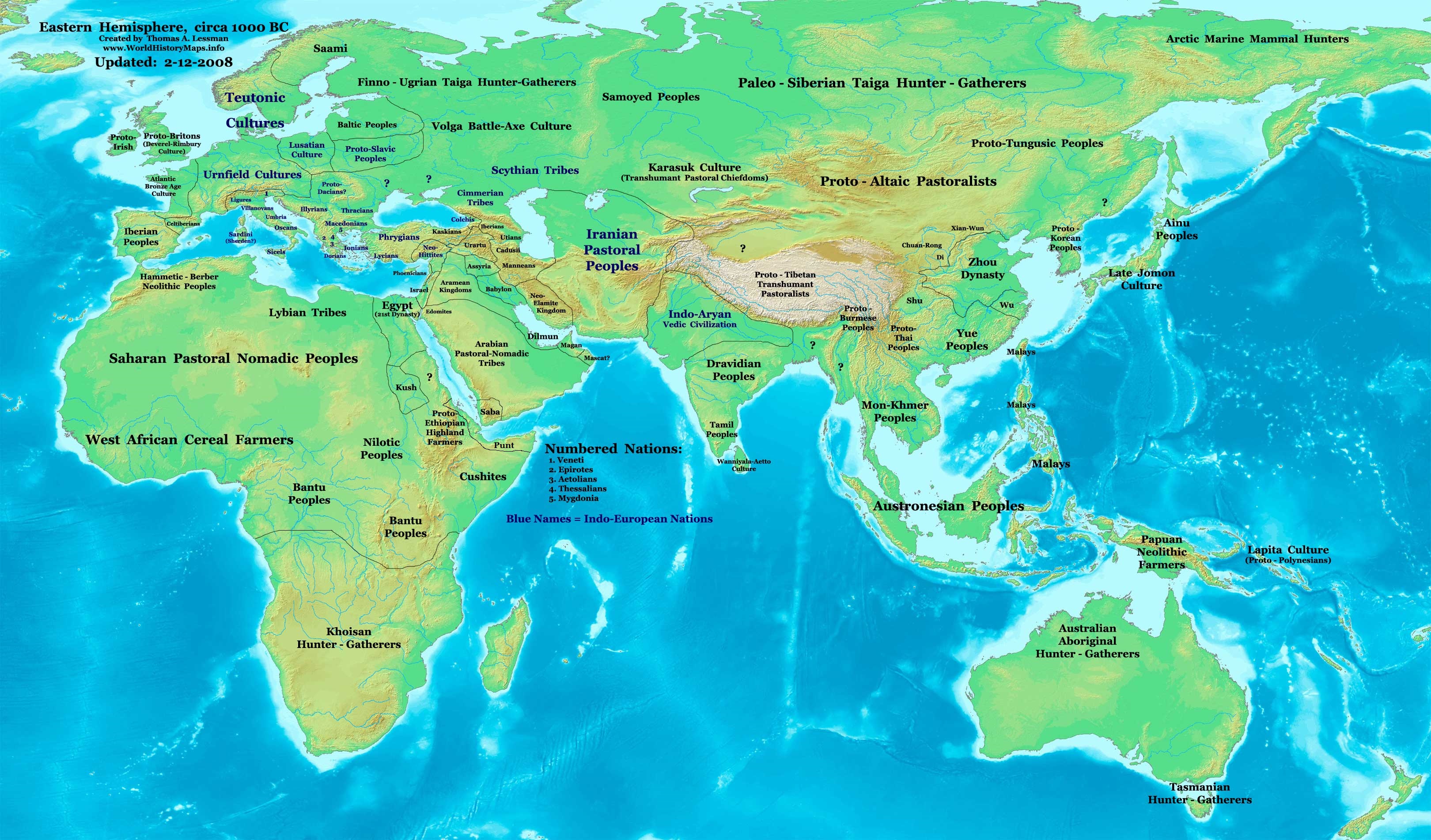
Eastern Hemisphere in 1000 BC.
Mənbə
self-made (For reference information, see below)
Müəllif
Thomas Lessman (Contact!)
Digər versiyalar
see East-Hem_1000bc.jpg file history on Wikipedia.
Lisenziya
I, the copyright holder of this work, hereby publish it under the following license:
Bu fayl Creative Commons Attribution-Share Alike 3.0 Sinqapur lisenziyası altında yayımlanır.
Azadsınız:
paylaşmaq – əsəri köçürmək, paylamaq və ötürmək üçün
remiks etmək – əsəri adaptasiya etmək
Aşağıdakı şərtlərə riayət etməklə:
istinad – Müvafiq kredit verməlisiniz, lisenziyaya bir keçid verməlisiniz və dəyişikliklərin olub olmadığını bildirməlisiniz. Bunu hər hansı bir ağlabatan şəkildə edə bilərsiniz, ancaq lisenziyalaşdırıcının sizi və ya istifadənizi təsdiqləməsini təklif edən bir şəkildə deyil.
bənzər paylaşma – Əsəri remix edirsinizsə, dəyişdirirsinizsə və ya üzərində iş aparırsınızsa, öz töhfələrinizi orijinalda olduğu kimi eyni və ya uyğun lisenziya altında yayımlamalısınız.
This map of the Eastern Hemisphere in 1000 BC was created by Thomas Lessman, based on information from the sources listed below. This map is free for educational use (see Permission info above). When using this map, please mention that it is available for free at www.WorldHistoryMaps.info.
Map Source References
Remember, sources often conflict with each other. This map is only as accurate as the information that is available to me. To report any errors or to help further this work, please click here, or email Thomas Lessman at talessman@yis.us
References for information contained in this map:
1. Some info derive from the map of the World 1000 BCE, created by User:Briangotts..
2. Zhou (China) borders derive partially from the Huhai.net map of China: 11th to 9th centuries BC.
3. Some information derives from DK Atlas of World History, 2000 edition.
4. Other information is based on various Wikipedia articles and google searches dealing with nations depicted in this map.
Other Maps by Thomas Lessman
Maps of the eastern hemisphere showing history
Bold dates are available on Wikimedia or Wikipedia. (Other dates are available on www.WorldHistoryMaps.info.) See also: * Disclaimers * Report Errors * Gallery of Maps
Primeval
·| 1300 BC | 1000 BC | 625 BC |
Ancient
BC / BCE
AD / CE
·| 600 BC | 550 BC | 527 BC | 500 BC | 400 BC | ·| 335 BC | 323 BC | 300 BC | 200 BC | ·| 100 BC | 50 BC |
·| 1 AD | 50 AD | 100 AD | 200 AD | 300 AD | ·| 400 AD | 475 AD | 476 AD | 477 AD | ·| 480 AD | 486 AD|
Medieval
·| 500 AD | 565 AD | 600 AD | 700 AD | · | 800 AD | 900 AD | 1025 AD | ·| 1100 AD | 1200 AD | 1300 AD | 1400 AD |
Modern
·| 1500 AD |·* For historical maps of the whole world, see Wikimedia's Template:Maps of world history.
history links talk edit view
Annotations
InfoField
This image is annotated: View the annotations at Commons
5
35
66
35
3240
1903
1300 BC
516
40
152
35
3240
1903
1000 BC
1245
304
137
61
3240
1903
Chariots
896
531
111
86
3240
1903
Syro-Hittite states
689
30
56
35
3240
1903
Maps showing 11th-century BCE history.
10th century BC: maps
9th century BC: maps
8th century BC: maps
7th century BC: maps
Captions
Add a one-line explanation of what this file represents
{{Information |Description='''Eastern Hemisphere in 1000 BC'''. |Source=self-made (For reference information, see below) |Author=Thomas Lessman (Contact!) |Date= |Location= |Permission={{self|cc-by-sa-3.0}} |othe
Fayl keçidləri
Bu faylı istifadə edən səhifə yoxdur.
Faylın qlobal istifadəsi
Bu fayl aşağıdakı vikilərdə istifadə olunur:
1st millennium BC
2nd millennium BC
10th century BC
1000s BC (decade)
Indo-Iranians
Late Bronze Age collapse
User:Talessman/Maps
User talk:Talessman/Maps
List of political entities in the 10th century BC
User:Benjamin Trovato/sandbox
Transjordan (region)
User:Falcaorib
Metaməlumatlar
Bu faylda fotoaparat və ya skanerlə əlavə olunmuş məlumatlar var. Əgər fayl sonradan redaktə olunubsa, bəzi parametrlər bu şəkildə göstərilənlərdən fərqli ola bilər.
Orientasiya
Normal
Oktyabr 29, 2023
fayl, east, 1000bc, fayl, faylın, tarixçəsi, fayl, keçidləri, faylın, qlobal, istifadəsi, metaməlumatlarsınaq, göstərişi, ölçüsü, piksel, digər, ölçülər, piksel, piksel, piksel, piksel, piksel, faylın, orijinalı, 8206, piksel, fayl, həcmi, mime, növü, image, j. Fayl Faylin tarixcesi Fayl kecidleri Faylin qlobal istifadesi MetamelumatlarSinaq gosterisi olcusu 800 470 piksel Diger olculer 320 188 piksel 640 376 piksel 1 024 601 piksel 1 280 752 piksel 3 240 1 903 piksel Faylin orijinali 8206 3 240 1 903 piksel fayl hecmi 1 43 MB MIME novu image jpeg Bu fayl Vikimedia Commons dadirve diger layihelerde istifade edile biler tesvir sehifesi Faylin tesvir sehifesine get This historical map image could be re created using vector graphics as an SVG file This has several advantages see nbsp Commons Media for cleanup for more information If nbsp an nbsp SVG nbsp form nbsp of nbsp this nbsp image is available please upload it and afterwards replace this template with vector version available i new image name i It is recommended to name the SVG file East Hem 1000bc svg then the template Vector version available or Vva does not need the new image name parameter This historical map image was uploaded in the JPEG format even though it consists of non photographic data This information could be stored more efficiently or accurately in the PNG or SVG format If possible please upload a PNG or SVG version of this image without compression artifacts derived from a non JPEG source or with existing artifacts removed After doing so please tag the JPEG version with Superseded NewImage ext and remove this tag This tag should not be applied to photographs or scans If this image is a diagram or other image suitable for vectorisation please tag this image with Convert to SVG instead of BadJPEG If not suitable for vectorisation use Convert to PNG For more information see BadJPEG IzahEast Hem 1000bc jpg Eastern Hemisphere in 1000 BC Menbe self made For reference information see below Muellif Thomas Lessman Contact Diger versiyalar see East Hem 1000bc jpg file history on Wikipedia Mundericat 1 Lisenziya 2 Map Summary 3 Map Source References 4 Other Maps by Thomas Lessman Lisenziya I the copyright holder of this work hereby publish it under the following license Bu fayl Creative Commons Attribution Share Alike 3 0 Sinqapur lisenziyasi altinda yayimlanir Azadsiniz paylasmaq eseri kocurmek paylamaq ve oturmek ucun remiks etmek eseri adaptasiya etmek Asagidaki sertlere riayet etmekle istinad Muvafiq kredit vermelisiniz lisenziyaya bir kecid vermelisiniz ve deyisikliklerin olub olmadigini bildirmelisiniz Bunu her hansi bir aglabatan sekilde ede bilersiniz ancaq lisenziyalasdiricinin sizi ve ya istifadenizi tesdiqlemesini teklif eden bir sekilde deyil benzer paylasma Eseri remix edirsinizse deyisdirirsinizse ve ya uzerinde is aparirsinizsa oz tohfelerinizi orijinalda oldugu kimi eyni ve ya uygun lisenziya altinda yayimlamalisiniz https creativecommons org licenses by sa 3 0 CC BY SA 3 0 Creative Commons Attribution Share Alike 3 0 true true Map Summary Original Source URL http www thomaslessman com History images East Hem 1000bc jpg This map of the Eastern Hemisphere in 1000 BC was created by Thomas Lessman based on information from the sources listed below This map is free for educational use see Permission info above When using this map please mention that it is available for free at www WorldHistoryMaps info Map Source References Remember sources often conflict with each other This map is only as accurate as the information that is available to me To report any errors or to help further this work please click here or email Thomas Lessman at talessman yis us References for information contained in this map 1 Some info derive from the map of the World 1000 BCE created by User Briangotts 2 Zhou China borders derive partially from the Huhai net map of China 11th to 9th centuries BC 3 Some information derives from DK Atlas of World History 2000 edition 4 Other information is based on various Wikipedia articles and google searches dealing with nations depicted in this map Other Maps by Thomas Lessman Maps of the eastern hemisphere showing history Bold dates are available on Wikimedia or Wikipedia Other dates are available on www WorldHistoryMaps info See also Disclaimers Report Errors Gallery of Maps Primeval 1300 BC 1000 BC 625 BC Ancient BC BCEAD CE 600 BC 550 BC 527 BC 500 BC 400 BC 335 BC 323 BC 300 BC 200 BC 100 BC 50 BC 1 AD 50 AD 100 AD 200 AD 300 AD 400 AD 475 AD 476 AD 477 AD 480 AD 486 AD Medieval 500 AD 565 AD 600 AD 700 AD nbsp 800 AD 900 AD 1025 AD 1100 AD 1200 AD 1300 AD 1400 AD Modern 1500 AD nbsp For historical maps of the whole world see Wikimedia s Template Maps of world history history nbsp links nbsp talk nbsp edit view AnnotationsInfoFieldThis image is annotated View the annotations at Commons5 35 66 35 3240 1903 1300 BC 516 40 152 35 3240 1903 1000 BC 1245 304 137 61 3240 1903 Chariots 896 531 111 86 3240 1903 Syro Hittite states 689 30 56 35 3240 1903 Maps showing 11th century BCE history 10th century BC maps9th century BC maps8th century BC maps7th century BC mapsCaptionsazerbaycancaAdd a one line explanation of what this file representsItems portrayed in this filetesvir ediryaradicisome valuemuellifin qisa adi Thomas LessmanURL https commons wikimedia org wiki user TalessmanWikimedia username nbsp ingilis Talessmancopyright status nbsp ingiliscopyrighted nbsp ingilislisenziyaCreative Commons Attribution ShareAlike 3 0 Unported nbsp ingilis Faylin tarixcesi Faylin evvelki versiyasini gormek ucun gun tarix bolmesindeki tarixlere klikleyin Tarix VaxtKicik sekilOlculerIstifadeciSerh indiki11 13 28 sentyabr 20233 240 1 903 1 43 MB Notradeuussrsadded Punt 07 15 9 may 20083 240 1 903 720 KB Talessman Information Description 039 039 039 Eastern Hemisphere in 1000 BC 039 039 039 Source self made For reference information see below Author Thomas Lessman Contact Date Location Permission self cc by sa 3 0 othe Fayl kecidleri Bu fayli istifade eden sehife yoxdur Faylin qlobal istifadesi Bu fayl asagidaki vikilerde istifade olunur ar wikipedia org layihesinde istifadesi شرق الأردن en wikipedia org layihesinde istifadesi Chaldea 1st millennium BC 2nd millennium BC 10th century BC 1000s BC decade Indo Iranians Late Bronze Age collapse User Talessman Maps User talk Talessman Maps List of political entities in the 10th century BC User Benjamin Trovato sandbox Transjordan region User Falcaorib gl wikipedia org layihesinde istifadesi Seculo X hy wikipedia org layihesinde istifadesi Անդրհորդանան hyw wikipedia org layihesinde istifadesi Անդրյորդանան ro wikipedia org layihesinde istifadesi Mileniul I i Hr sv wikipedia org layihesinde istifadesi 1000 talet f Kr tr wikipedia org layihesinde istifadesi Transurdun bolge Metamelumatlar Bu faylda fotoaparat ve ya skanerle elave olunmus melumatlar var Eger fayl sonradan redakte olunubsa bezi parametrler bu sekilde gosterilenlerden ferqli ola biler OrientasiyaNormal Menbe https az wikipedia org wiki Fayl East Hem 1000bc jpg, wikipedia, oxu, kitab, kitabxana, axtar, tap, hersey,
ne axtarsan burda
, en yaxsi meqale sayti, meqaleler, kitablar, oyrenmek, wiki, bilgi, tarix, seks, porno, indir, yukle, sex, azeri sex, azeri, seks yukle, sex yukle, izle, seks izle, porno izle, mobil seks, telefon ucun, chat, azeri chat, tanisliq, tanishliq, azeri tanishliq, sayt, medeni, medeni saytlar, chatlar, mekan, tanisliq mekani, mekanlari, yüklə, pulsuz, pulsuz yüklə, mp3, video, mp4, 3gp, jpg, jpeg, gif, png, şəkil, muisiqi, mahnı, kino, film, kitab, oyun, oyunlar.