This W3C-unspecified vector image was created with Inkscape…important .
This SVG file contains embedded text that can be translated into your language, using any capable SVG editor, text editor or the SVG Translate tool. For more information see: About translating SVG files.
Graphic Lab
InfoField
Bu xəritə Qrafik emalatxanada (fr) yaradılmışdır. Siz həmçinin təsvirin yaxşılaşması ilə bağlı müraciət edə bilərsiniz.
Camera location
44° 00′ 00″ N, 18° 00′ 00″ E
View this and other nearby images on: OpenStreetMap
44.000000; 18.000000
Lisenziya
I, the copyright holder of this work, hereby publish it under the following licenses:
Copyleft: This work of art is free; you can redistribute it and/or modify it according to terms of the Free Art License. You will find a specimen of this license on the Copyleft Attitude site as well as on other sites. http://artlibre.org/licence/lal/enFALFree Art Licensefalsetrue
This file is licensed under the Creative Commons Attribution-Share Alike 4.0 International, 3.0 Unported, 2.5 Generic, 2.0 Generic and 1.0 Generic license.
Azadsınız:
paylaşmaq – əsəri köçürmək, paylamaq və ötürmək üçün
remiks etmək – əsəri adaptasiya etmək
Aşağıdakı şərtlərə riayət etməklə:
istinad – Müvafiq kredit verməlisiniz, lisenziyaya bir keçid verməlisiniz və dəyişikliklərin olub olmadığını bildirməlisiniz. Bunu hər hansı bir ağlabatan şəkildə edə bilərsiniz, ancaq lisenziyalaşdırıcının sizi və ya istifadənizi təsdiqləməsini təklif edən bir şəkildə deyil.
bənzər paylaşma – Əsəri remix edirsinizsə, dəyişdirirsinizsə və ya üzərində iş aparırsınızsa, öz töhfələrinizi orijinalda olduğu kimi eyni və ya uyğun lisenziya altında yayımlamalısınız.
Bu faylda fotoaparat və ya skanerlə əlavə olunmuş məlumatlar var. Əgər fayl sonradan redaktə olunubsa, bəzi parametrlər bu şəkildə göstərilənlərdən fərqli ola bilər.
Genişlik
1857
Hündürlük
1503
May 10, 2023
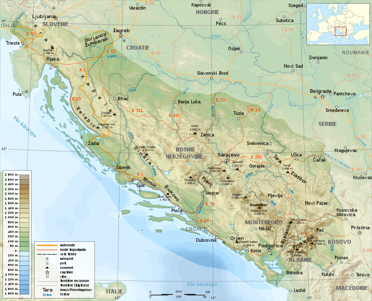
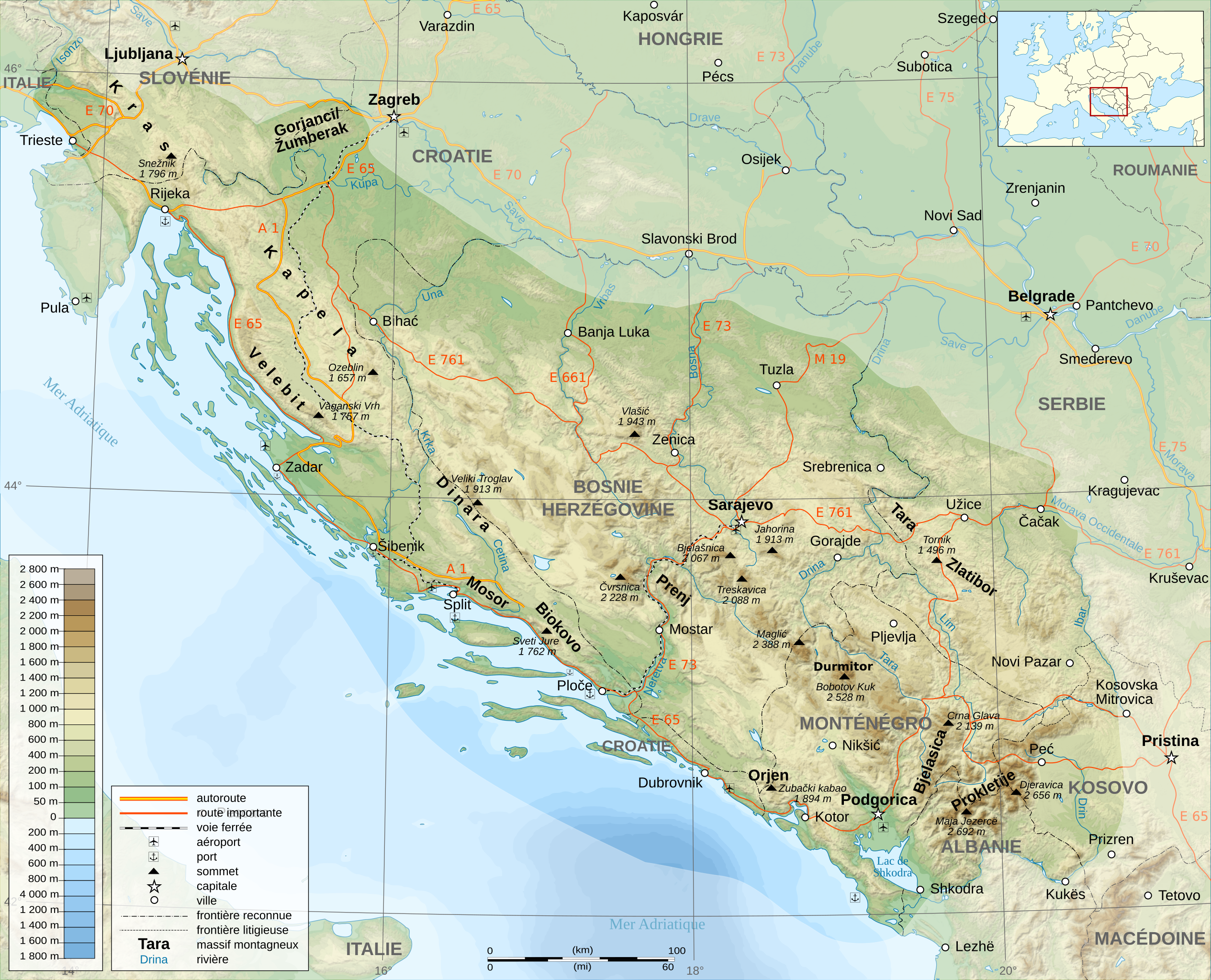
fayl, dinaric, alps, fayl, faylın, tarixçəsi, fayl, keçidləri, faylın, qlobal, istifadəsi, metaməlumatlarbu, faylın, formatındakı, görünüşünün, ölçüsü, piksel, digər, ölçülər, piksel, piksel, piksel, piksel, piksel, piksel, faylın, orijinalı, 8206, faylı, nomi. Fayl Faylin tarixcesi Fayl kecidleri Faylin qlobal istifadesi MetamelumatlarBu SVG faylin PNG formatindaki bu gorunusunun olcusu 741 600 piksel Diger olculer 297 240 piksel 593 480 piksel 949 768 piksel 1 265 1 024 piksel 2 530 2 048 piksel 1 857 1 503 piksel Faylin orijinali 8206 SVG fayli nominal olaraq 1 857 1 503 piksel faylin olcusu 3 63 MB Bu fayl Vikimedia Commons dadirve diger layihelerde istifade edile biler Faylin tesvir sehifesine get Xulase IzahDinaric Alps map fr svg English A general map of The Dinaric Alps in French Francais nbsp Un carte generale de la chaine des Le Alpes Dinariques Tarix 18 noyabr 2008 Menbe travail personnel own work Sources nbsp Background map nbsp NASA Shuttle Radar Topography Mission SRTM3 v 2 public domain Image Dinarisches Gebirge Topo png by FelixReimann under licence GFDL Bathymetry rivers borders cities roads nbsp Demis see the approval e mail and the Demis forum Locator map made from Blank map of Europe Atelier graphique colors svg created by Historicair under GFDL amp CC BY SA 2 5 Other things scale symbols from Image Maps template fr svg by Sting under GFDL amp CC BY SA 3 0 Softwares used NASA datas edited with 3DEM and Global Mapper 9 limited version by the United States Geological Survey USGS Demis data edited with Demis Mapper Vectorized with Inkscape Cartographic tutorials in french Others UTM map projection WGS84 geodetic system Shaded relief ligth direction nbsp altitude 80 azimuth 315 Font Liberation Sans amp Liberation Serif The background map is a raster image embedded in the SVG file Muellif Semhur Diger versiyalar Derivative works of this file Dinaric Alps map es svg Republika Srpska Topography Map Blank svgIstinad required by the license InfoField c Semhur nbsp nbsp Wikimedia Commons nbsp nbsp CC BY SA 3 0 or Free Art LicenseInfoField c Semhur nbsp nbsp Wikimedia Commons SVGInfoField nbsp W3C validity not checked nbsp This W3C unspecified vector image was created with Inkscape important This SVG file contains embedded text that can be translated into your language using any capable SVG editor text editor or the SVG Translate tool For more information see About translating SVG files Graphic LabInfoFieldBu xerite Qrafik emalatxanada fr yaradilmisdir Siz hemcinin tesvirin yaxsilasmasi ile bagli muraciet ede bilersiniz Camera location44 nbsp 00 nbsp 00 nbsp N 18 nbsp 00 nbsp 00 nbsp E nbsp View this and other nearby images on OpenStreetMap44 000000 18 000000 Lisenziya I the copyright holder of this work hereby publish it under the following licenses Copyleft This work of art is free you can redistribute it and or modify it according to terms of the Free Art License You will find a specimen of this license on the Copyleft Attitude site as well as on other sites http artlibre org licence lal en FAL Free Art License false trueThis file is licensed under the Creative Commons Attribution Share Alike 4 0 International 3 0 Unported 2 5 Generic 2 0 Generic and 1 0 Generic license Azadsiniz paylasmaq eseri kocurmek paylamaq ve oturmek ucun remiks etmek eseri adaptasiya etmek Asagidaki sertlere riayet etmekle istinad Muvafiq kredit vermelisiniz lisenziyaya bir kecid vermelisiniz ve deyisikliklerin olub olmadigini bildirmelisiniz Bunu her hansi bir aglabatan sekilde ede bilersiniz ancaq lisenziyalasdiricinin sizi ve ya istifadenizi tesdiqlemesini teklif eden bir sekilde deyil benzer paylasma Eseri remix edirsinizse deyisdirirsinizse ve ya uzerinde is aparirsinizsa oz tohfelerinizi orijinalda oldugu kimi eyni ve ya uygun lisenziya altinda yayimlamalisiniz https creativecommons org licenses by sa 4 0 CC BY SA 4 0 Creative Commons Attribution Share Alike 4 0 true trueIstediyiniz lisenziyani sece bilersiniz CaptionsazerbaycancaAdd a one line explanation of what this file representsitalyanAlpi DinaricheItems portrayed in this filetesvir ediryaradiciSome value without a Vikiverilenler itemURL nbsp ingilis https commons wikimedia org wiki user S C3 A9mhurWikimedia username nbsp ingilis Semhurobyektin rolu fotoqrafmuellifin qisa adi Semhurcopyright status nbsp ingiliscopyrighted nbsp ingilislisenziyaFree Art License nbsp ingilisCreative Commons Attribution ShareAlike 2 5 Generic nbsp ingilisCreative Commons Attribution ShareAlike 1 0 Generic nbsp ingilisCreative Commons Attribution ShareAlike 4 0 International nbsp ingilisCreative Commons Attribution ShareAlike 3 0 Unported nbsp ingilisCreative Commons Attribution ShareAlike 2 0 Generic nbsp ingilisyaranma tarixi18 noyabr 2008coordinates of the point of view nbsp ingilis44 N 18 E Faylin tarixcesi Faylin evvelki versiyasini gormek ucun gun tarix bolmesindeki tarixlere klikleyin Tarix VaxtKicik sekilOlculerIstifadeciSerh indiki15 38 23 noyabr 20081 857 1 503 3 63 MB SemhurCorrection autoroutes 21 52 18 noyabr 20081 857 1 503 3 75 MB SemhurBonne version 19 26 18 noyabr 20081 857 1 503 3 58 MB SemhurCorrection du nom d 039 une montagne 19 21 18 noyabr 20081 857 1 503 3 58 MB Semhur Information Description en 1 General map of Dinaric Alps in French fr 1 Carte generale de la chaine des Alpes Dinariques Source travail personnel own work Sources Background map htt Fayl kecidleri Bu fayli istifade eden sehife yoxdur Faylin qlobal istifadesi Bu fayl asagidaki vikilerde istifade olunur ca wikipedia org layihesinde istifadesi Alps Dinarics fr wikipedia org layihesinde istifadesi Alpes dinariques Utilisateur Gemini1980 Wikipedia Lumiere sur Alpes dinariques Wikipedia Atelier graphique Cartes Archives fevrier 2009 Wikipedia Selection Montagne Wikipedia Selection Croatie Wikipedia Lumiere sur Mars 2015 Wikipedia Lumiere sur Avril 2023 hu wikipedia org layihesinde istifadesi Dinari hegyseg it wikipedia org layihesinde istifadesi Alpi Dinariche Montagne della Bosnia ed Erzegovina la wikipedia org layihesinde istifadesi Alpes Illyricae nn wikipedia org layihesinde istifadesi SavaMetamelumatlar Bu faylda fotoaparat ve ya skanerle elave olunmus melumatlar var Eger fayl sonradan redakte olunubsa bezi parametrler bu sekilde gosterilenlerden ferqli ola biler Genislik1857Hundurluk1503 Menbe https az wikipedia org wiki Fayl Dinaric Alps map fr svg, wikipedia, oxu, kitab, kitabxana, axtar, tap, hersey,
ne axtarsan burda
, en yaxsi meqale sayti, meqaleler, kitablar, oyrenmek, wiki, bilgi, tarix, seks, porno, indir, yukle, sex, azeri sex, azeri, seks yukle, sex yukle, izle, seks izle, porno izle, mobil seks, telefon ucun, chat, azeri chat, tanisliq, tanishliq, azeri tanishliq, sayt, medeni, medeni saytlar, chatlar, mekan, tanisliq mekani, mekanlari, yüklə, pulsuz, pulsuz yüklə, mp3, video, mp4, 3gp, jpg, jpeg, gif, png, şəkil, muisiqi, mahnı, kino, film, kitab, oyun, oyunlar.