Bu fayl "Vikimedia Commons"dadır və digər layihələrdə istifadə edilə bilər.
Faylın təsvir səhifəsinə get
Xülasə
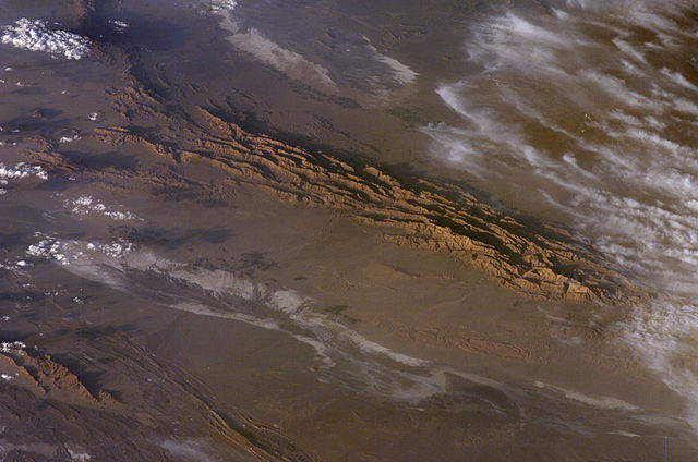
Winter in the Dasht-e-Lut Desert, eastern Iran
An International Space Station crew member took this striking photograph one evening in late February. The image takes advantage of the Sun’s low angle to reveal linear geological structures of the Iranian mountain range bordering the western edge of the basin known as Dasht-e-Lut. The range rises 1,818 meters (6,000 feet) above sea level and lies 750 kilometers (466 miles) north of the Persian Gulf. The convoluted appearance results from erosion of folded and faulted rocks—softer rocks erode away quickly, leaving more resistant rock to form linear ridges that are perpendicular to the direction of compression. While not a major oil-producing region like the Zagros Fold Belt to the southwest, the mountains of east-central Iran contain economically important deposits of copper and other metals.
Little vegetation can be seen from space in the arid interior basin of the Dasht-e-Lut. Iran is climatically part of the Afro-Asian belt of deserts that stretch from the Cape Verde islands off West Africa all the way to Mongolia near Beijing, China. The patchy, elongated, light-colored feature in the foreground (parallel to the mountain range) is the northernmost of the Dasht dry lakes that stretch southward 300 kilometers (186 miles). In near-tropical deserts, elevated areas capture most precipitation. Agricultural fields that depend on this precipitation appear as small dark patches in this image. They are located downslope, near the margin of the lake’s dry, salty soils.
Bu faylda fotoaparat və ya skanerlə əlavə olunmuş məlumatlar var. Əgər fayl sonradan redaktə olunubsa, bəzi parametrlər bu şəkildə göstərilənlərdən fərqli ola bilər.
_error
0
May 09, 2023
fayl, dasht, iran, 2006, iss012, 18779, fayl, faylın, tarixçəsi, fayl, keçidləri, faylın, qlobal, istifadəsi, metaməlumatlarsınaq, göstərişi, ölçüsü, piksel, digər, ölçülər, piksel, piksel, piksel, faylın, orijinalı, 8206, piksel, fayl, həcmi, mime, növü, imag. Fayl Faylin tarixcesi Fayl kecidleri Faylin qlobal istifadesi MetamelumatlarSinaq gosterisi olcusu 800 530 piksel Diger olculer 320 212 piksel 640 424 piksel 1 000 663 piksel Faylin orijinali 8206 1 000 663 piksel fayl hecmi 237 KB MIME novu image jpeg Bu fayl Vikimedia Commons dadirve diger layihelerde istifade edile biler Faylin tesvir sehifesine get Xulase Winter in the Dasht e Lut Desert eastern IranAn International Space Station crew member took this striking photograph one evening in late February The image takes advantage of the Sun s low angle to reveal linear geological structures of the Iranian mountain range bordering the western edge of the basin known as Dasht e Lut The range rises 1 818 meters 6 000 feet above sea level and lies 750 kilometers 466 miles north of the Persian Gulf The convoluted appearance results from erosion of folded and faulted rocks softer rocks erode away quickly leaving more resistant rock to form linear ridges that are perpendicular to the direction of compression While not a major oil producing region like the Zagros Fold Belt to the southwest the mountains of east central Iran contain economically important deposits of copper and other metals Little vegetation can be seen from space in the arid interior basin of the Dasht e Lut Iran is climatically part of the Afro Asian belt of deserts that stretch from the Cape Verde islands off West Africa all the way to Mongolia near Beijing China The patchy elongated light colored feature in the foreground parallel to the mountain range is the northernmost of the Dasht dry lakes that stretch southward 300 kilometers 186 miles In near tropical deserts elevated areas capture most precipitation Agricultural fields that depend on this precipitation appear as small dark patches in this image They are located downslope near the margin of the lake s dry salty soils Source http earthobservatory nasa gov Newsroom NewImages images php3 img id 17226 1 http eol jsc nasa gov scripts sseop photo pl mission ISS012 amp roll E amp frame 18779 Lisenziya Public domain Public domain false false This file is in the public domain in the United States because it was solely created by NASA NASA copyright policy states that NASA material is not protected by copyright unless noted See Template PD USGov NASA copyright policy page or JPL Image Use Policy Warnings Use of NASA logos insignia and emblems is restricted per U S law 14 CFR 1221 The NASA website hosts a large number of images from the Soviet Russian space agency and other non American space agencies These are not necessarily in the public domain Materials based on Hubble Space Telescope data may be copyrighted if they are not explicitly produced by the STScI 2 See also PD Hubble and Cc Hubble The SOHO ESA amp NASA joint project implies that all materials created by its probe are copyrighted and require permission for commercial non educational use 3 Images featured on the Astronomy Picture of the Day APOD web site may be copyrighted 4 The National Space Science Data Center NSSDC site has been known to host copyrighted content Its photo gallery FAQ states that all of the images in the photo gallery are in the public domain Unless otherwise noted Faylin tarixcesi Faylin evvelki versiyasini gormek ucun gun tarix bolmesindeki tarixlere klikleyin Tarix VaxtKicik sekilOlculerIstifadeciSerh indiki05 52 29 mart 20061 000 663 237 KB PmsyyzDasht e Lut a desert in Iran Fayl kecidleri Bu sekile olan kecidler Desti Lut Sehralarin dunyada sahesine gore siralamasi Faylin qlobal istifadesi Bu fayl asagidaki vikilerde istifade olunur ar wikipedia org layihesinde istifadesi قائمة الصحاري حسب المساحة bg wikipedia org layihesinde istifadesi Spisk na pustini po plosh Deshe Lut bn wikipedia org layihesinde istifadesi ব হত তম মর ভ ম র ত ল ক bs wikipedia org layihesinde istifadesi Spisak pustinja po povrsini Dast e Lut ca wikipedia org layihesinde istifadesi Erg ckb wikipedia org layihesinde istifadesi پێڕستی بیابانەکان بەپێی ڕووبەر cs wikipedia org layihesinde istifadesi Lut de wikipedia org layihesinde istifadesi Welterbe in Iran Dascht e Lut el wikipedia org layihesinde istifadesi Erhmos Loyt en wikipedia org layihesinde istifadesi List of deserts by area List of ergs es wikipedia org layihesinde istifadesi Desierto de Lut et wikipedia org layihesinde istifadesi Dasht e Lut Suurimate korbete loend eu wikipedia org layihesinde istifadesi Lut basamortua fa wikipedia org layihesinde istifadesi درگاه کرمان درگاه کرمان گردشگری درگاه کرمان گردشگری ۱ فهرست بیابان ها بر پایه مساحت fi wikipedia org layihesinde istifadesi Iso Hiekka aavikko Iran Luettelo aavikoista pinta alan mukaan fr wikipedia org layihesinde istifadesi Liste du patrimoine mondial en Iran Liste d ergs gd wikipedia org layihesinde istifadesi Dasht e Lut he wikipedia org layihesinde istifadesi מדבר לוט hu wikipedia org layihesinde istifadesi Dast e Lut hy wikipedia org layihesinde istifadesi Մասնակից GeoO UNESCO it wikipedia org layihesinde istifadesi Geografia dell Iran Dasht e Lut ja wikipedia org layihesinde istifadesi ルート砂漠 ka wikipedia org layihesinde istifadesi უდაბნოების სია ფართობის მიხედვით დაშთე ლუთი kk wikipedia org layihesinde istifadesi Aumagy bojynsha sholder tizimi kn wikipedia org layihesinde istifadesi ವ ಶ ವದ ಅತ ದ ಡ ಡ ಮರ ಭ ಮ ಗಳ ko wikipedia org layihesinde istifadesi 루트 사막 ky wikipedia org layihesinde istifadesi Deshte lut lfn wikipedia org layihesinde istifadesi Deserto lt wikipedia org layihesinde istifadesi Deste Lutas Sarasas Dykumos pagal plota meta wikimedia org layihesinde istifadesi UNESCO Challenge Wikidata list mk wikipedia org layihesinde istifadesi Spisok na pustini po povrshina Deshte Lut ml wikipedia org layihesinde istifadesi വ സ ത ർണ ണമന സര ച ച ള ള മര ഭ മ കള ട പട ട ക no wikipedia org layihesinde istifadesi Dasht e Lut pl wikipedia org layihesinde istifadesi Daszt e Lut pnb wikipedia org layihesinde istifadesi دشت لوط ps wikipedia org layihesinde istifadesi لوط دښته Bu faylin qlobal istifadesine baxin Metamelumatlar Bu faylda fotoaparat ve ya skanerle elave olunmus melumatlar var Eger fayl sonradan redakte olunubsa bezi parametrler bu sekilde gosterilenlerden ferqli ola biler error0 Menbe https az wikipedia org wiki Fayl Dasht e Lut Iran 2006 02 28 ISS012 E 18779 jpg, wikipedia, oxu, kitab, kitabxana, axtar, tap, hersey,
ne axtarsan burda
, en yaxsi meqale sayti, meqaleler, kitablar, oyrenmek, wiki, bilgi, tarix, seks, porno, indir, yukle, sex, azeri sex, azeri, seks yukle, sex yukle, izle, seks izle, porno izle, mobil seks, telefon ucun, chat, azeri chat, tanisliq, tanishliq, azeri tanishliq, sayt, medeni, medeni saytlar, chatlar, mekan, tanisliq mekani, mekanlari, yüklə, pulsuz, pulsuz yüklə, mp3, video, mp4, 3gp, jpg, jpeg, gif, png, şəkil, muisiqi, mahnı, kino, film, kitab, oyun, oyunlar.
![[1]](http://earthobservatory.nasa.gov/Newsroom/NewImages/Images/ISS012-E-18779_lrg.jpg)