Bu fayl "Vikimedia Commons"dadır və digər layihələrdə istifadə edilə bilər.
Faylın təsvir səhifəsinə get
Xülasə
İzahDasht-e Kavir.jpg
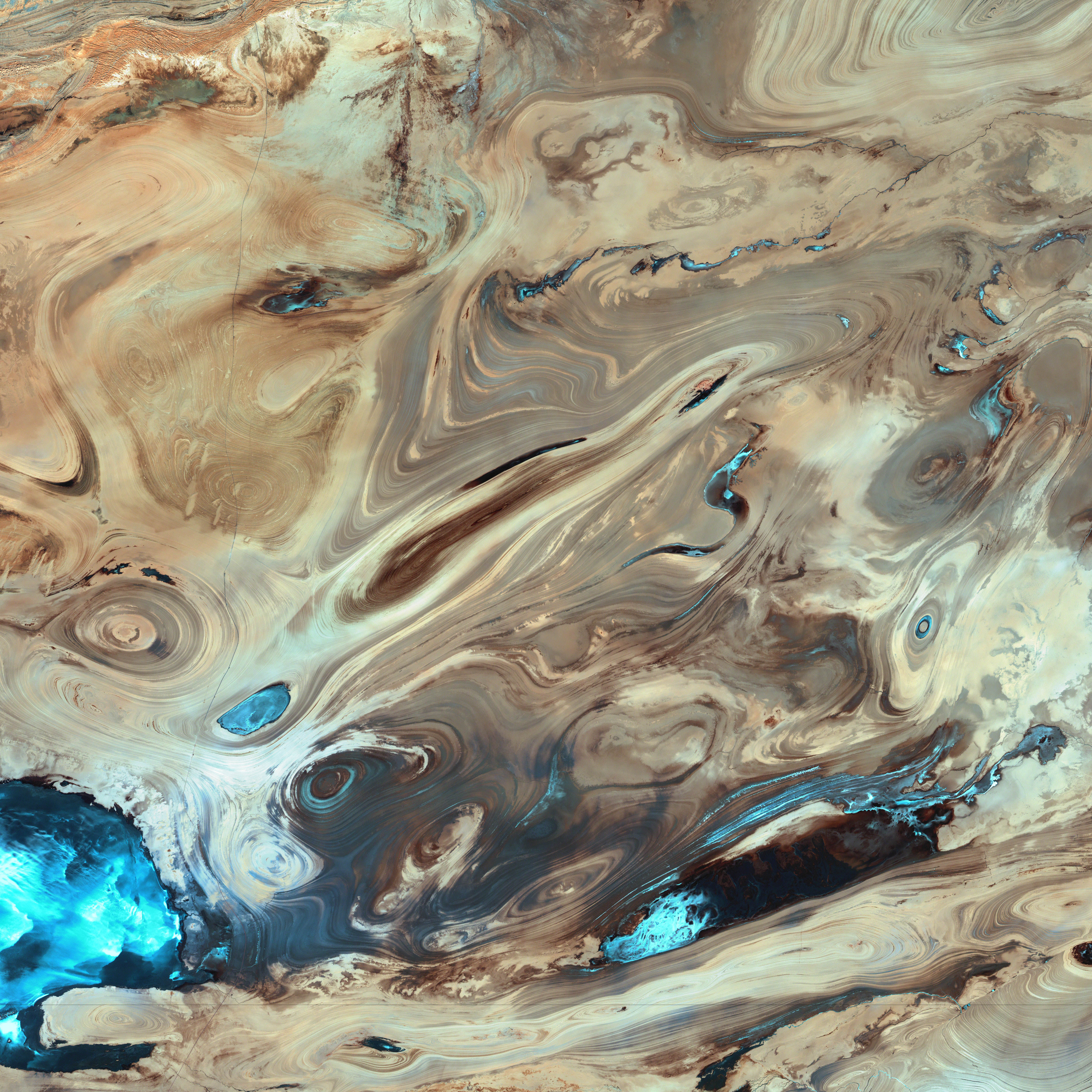
English: A satellite picture of the Dasht-e Kavir desert in Iran.
The patterns you see are formed by different geological layers that have been eroded over thousands of years by wind and sometimes (but not often) rain.
The patterns are formed from either horizontal geological layers cut through by topographic changes, or geological formations (folds, domes, etc) in relatively flat terrain.
Most of the colours are due to chemical differences in the rocks, whilst the intense blue colours could be due to a range of materials, possibly salt deposits, possibly vegetation, depending on which area of the EM spectrum is represented by blue. I suspect (but don't know, the satellite bands to displayed colours are not mentioned) that the blue colours are salt deposits, but they could equally be other materials too. To be certain, knowledge of the bands to display colours is essential.
The black line running horizontally across the image is a sensor drop-out and the data for that line or lines has been irrevocably lost. The linear (but not straight) line running vertically down the middle left is a road.
USGS/NASA description: The Dasht-e Kevir, or Great Salt Desert, is the largest desert in Iran. It is primarily uninhabited wasteland, composed of mud and salt marshes covered with crusts of salt that protect the meager moisture from completely evaporating. This image was acquired by Landsat 7’s Enhanced Thematic Mapper plus (ETM+) sensor on October 24, 2000. This is a false-color composite image made using infrared, green, and red wavelengths. The image has also been sharpened using the sensor’s panchromatic band.
فارسی: تصویر ماهوارهای از دشت کویر ایران. اکثر رنگهای موجود در نگاره و تفاوتهای شیدهای مختلف، به دلایل اختلافهای ترکیبات شیمیایی مواد تشکیل دهنده صخرهها و تپهها است که در کنار یکدیگر جلوهگر شدهاند. رنگهای تند آبی احتمالاً ناشی از رسوب نمکهای باقی مانده از رستنیها و گیاهان کویری است. البته این استنتاج بستگی مستقیم به طیف الکترومغناطیسی دارد که با رنگ آبی نمایش داده شدهاست.
Tarix
Mənbə
NASA Earth Observatory.
Müəllif
USGS EROS Data Center Satellite Systems Branch.
Object location
34° 45′ 18,82″ N, 54° 51′ 45,1″ E
View this and other nearby images on: OpenStreetMap
34.755228; 54.862528
(centre of image)
Lisenziya
Public domainPublic domainfalsefalse
Public domainPublic domainfalsefalse
This is a featured picture on Wikimedia Commons (Featured pictures) and is considered one of the finest images. This is a featured picture on the fars language Wikipedia (نگارههای برگزیده) and is considered one of the finest images.
If you have an image of similar quality that can be published under a suitable copyright license, be sure to upload it, tag it, and nominate it.
Annotations
InfoField
This image is annotated: View the annotations at Commons
10
5277
5773
155
5822
5820
sensor drop-out
1232
39
175
1630
5822
5820
section of road
Captions
Add a one-line explanation of what this file represents
False-color composite image of Dash-t Kevir desert in Iran, photographed by satellite.
Items portrayed in this file
təsvir edir
Dəşti-Kəbir
Commons quality assessment ingilis
Wikimedia Commons featured picture ingilis
yaranma tarixi
24 oktyabr 2000
coordinates of depicted place ingilis
34°45'18.821"N, 54°51'45.101"E
MIME type ingilis
image/jpeg
Faylın tarixçəsi
Faylın əvvəlki versiyasını görmək üçün gün/tarix bölməsindəki tarixlərə klikləyin.
Bu faylda fotoaparat və ya skanerlə əlavə olunmuş məlumatlar var. Əgər fayl sonradan redaktə olunubsa, bəzi parametrlər bu şəkildə göstərilənlərdən fərqli ola bilər.
_error
0
Yanvar 24, 2023
fayl, dasht, kavir, fayl, faylın, tarixçəsi, istifadə, edilən, səhifələr, faylın, qlobal, istifadəsi, metaməlumatlarsınaq, göstərişi, ölçüsü, piksel, digər, ölçülər, piksel, piksel, piksel, piksel, piksel, piksel, faylın, orijinalı, 8206, piksel, fayl, həcmi, . Fayl Faylin tarixcesi Istifade edilen sehifeler Faylin qlobal istifadesi MetamelumatlarSinaq gosterisi olcusu 600 600 piksel Diger olculer 240 240 piksel 480 480 piksel 768 768 piksel 1 024 1 024 piksel 2 049 2 048 piksel 5 822 5 820 piksel Faylin orijinali 8206 5 822 5 820 piksel fayl hecmi 3 5 MB MIME novu image jpeg Bu fayl Vikimedia Commons dadirve diger layihelerde istifade edile biler Faylin tesvir sehifesine get Xulase IzahDasht e Kavir jpg English A satellite picture of the Dasht e Kavir desert in Iran The patterns you see are formed by different geological layers that have been eroded over thousands of years by wind and sometimes but not often rain The patterns are formed from either horizontal geological layers cut through by topographic changes or geological formations folds domes etc in relatively flat terrain Most of the colours are due to chemical differences in the rocks whilst the intense blue colours could be due to a range of materials possibly salt deposits possibly vegetation depending on which area of the EM spectrum is represented by blue I suspect but don t know the satellite bands to displayed colours are not mentioned that the blue colours are salt deposits but they could equally be other materials too To be certain knowledge of the bands to display colours is essential The black line running horizontally across the image is a sensor drop out and the data for that line or lines has been irrevocably lost The linear but not straight line running vertically down the middle left is a road USGS NASA description The Dasht e Kevir or Great Salt Desert is the largest desert in Iran It is primarily uninhabited wasteland composed of mud and salt marshes covered with crusts of salt that protect the meager moisture from completely evaporating This image was acquired by Landsat 7 s Enhanced Thematic Mapper plus ETM sensor on October 24 2000 This is a false color composite image made using infrared green and red wavelengths The image has also been sharpened using the sensor s panchromatic band فارسی تصویر ماهواره ای از دشت کویر ایران اکثر رنگ های موجود در نگاره و تفاوت های شیدهای مختلف به دلایل اختلاف های ترکیبات شیمیایی مواد تشکیل دهنده صخره ها و تپه ها است که در کنار یکدیگر جلوه گر شده اند رنگ های تند آبی احتمالا ناشی از رسوب نمک های باقی مانده از رستنی ها و گیاهان کویری است البته این استنتاج بستگی مستقیم به طیف الکترومغناطیسی دارد که با رنگ آبی نمایش داده شده است Tarix 24 oktyabr 2000Menbe NASA Earth Observatory Muellif USGS EROS Data Center Satellite Systems Branch Object location34 45 18 82 N 54 51 45 1 E View this and other nearby images on OpenStreetMap34 755228 54 862528 centre of image Lisenziya Public domain Public domain false falseThis file is in the public domain in the United States because it was solely created by NASA NASA copyright policy states that NASA material is not protected by copyright unless noted See Template PD USGov NASA copyright policy page or JPL Image Use Policy Warnings Use of NASA logos insignia and emblems is restricted per U S law 14 CFR 1221 The NASA website hosts a large number of images from the Soviet Russian space agency and other non American space agencies These are not necessarily in the public domain Materials based on Hubble Space Telescope data may be copyrighted if they are not explicitly produced by the STScI 1 See also PD Hubble and Cc Hubble The SOHO ESA amp NASA joint project implies that all materials created by its probe are copyrighted and require permission for commercial non educational use 2 Images featured on the Astronomy Picture of the Day APOD web site may be copyrighted 3 The National Space Science Data Center NSSDC site has been known to host copyrighted content Its photo gallery FAQ states that all of the images in the photo gallery are in the public domain Unless otherwise noted Public domain Public domain false falseThis image is in the public domain in the United States because it only contains materials that originally came from the United States Geological Survey an agency of the United States Department of the Interior For more information see the official USGS copyright policy Bahasa Indonesia catala cestina Deutsch eesti English espanol francais galego italiano Nederlands portugues polski sicilianu suomi Tiếng Việt Turkce blgarski makedonski russkij മലയ ള 한국어 日本語 中文 中文 简体 中文 繁體 العربية فارسی This is a featured picture on Wikimedia Commons Featured pictures and is considered one of the finest images This is a featured picture on the fars language Wikipedia نگاره های برگزیده and is considered one of the finest images If you have an image of similar quality that can be published under a suitable copyright license be sure to upload it tag it and nominate it AnnotationsInfoFieldThis image is annotated View the annotations at Commons10 5277 5773 155 5822 5820 sensor drop out 1232 39 175 1630 5822 5820 section of roadCaptionsazerbaycancaAdd a one line explanation of what this file representsingilisFalse color composite image of Dash t Kevir desert in Iran photographed by satellite Items portrayed in this filetesvir edirDesti KebirCommons quality assessment ingilisWikimedia Commons featured picture ingilisyaranma tarixi24 oktyabr 2000coordinates of depicted place ingilis34 45 18 821 N 54 51 45 101 EMIME type ingilisimage jpeg Faylin tarixcesi Faylin evvelki versiyasini gormek ucun gun tarix bolmesindeki tarixlere klikleyin Tarix VaxtKicik sekilOlculerIstifadeciSerh indiki20 39 18 yanvar 20065 822 5 820 3 5 MB David Monniauxran it through jpegtran to output optimized non progressive jpeg 20 09 18 yanvar 20065 822 5 820 3 66 MB PalladinusDasht e Kavir desert in Iran Istifade edilen sehifeler Bu sekile olan kecidler Desti Kevir Faylin qlobal istifadesi Bu fayl asagidaki vikilerde istifade olunur als wikipedia org layihesinde istifadesi Iran ar wikipedia org layihesinde istifadesi صحراء كوير الحياة البرية في إيران azb wikipedia org layihesinde istifadesi ایران be wikipedia org layihesinde istifadesi Deshte Kevir bg wikipedia org layihesinde istifadesi Deshe Kevir bs wikipedia org layihesinde istifadesi Geomorfologija Irana ca wikipedia org layihesinde istifadesi Orient Mitja Daixt e Kavir cs wikipedia org layihesinde istifadesi Dast e Kavir de wikipedia org layihesinde istifadesi Iran Geographie Irans Liste von Wusten in Asien en wikipedia org layihesinde istifadesi User Phaedriel Soundtrack of Wikipedians User Passargea Favourite pictures Nature User Altenmann Wikipedia Featured picture candidates February 2013 Wikipedia Featured picture candidates Dasht e Kavir User Swazmo CarouselPics User Jemspar sandbox es wikipedia org layihesinde istifadesi Oriente Proximo Usuario Swazmo Carrusel de imagenes es wikibooks org layihesinde istifadesi Usuario Swazmo Carrusel de imagenes es wikisource org layihesinde istifadesi Usuario Swazmo Carrusel de imagenes et wikipedia org layihesinde istifadesi Geomorfoloogia Dasht e Kavir eu wikipedia org layihesinde istifadesi Kavir basamortua fa wikipedia org layihesinde istifadesi دشت کویر ویکی پدیا انتخاب نگاره هفته سال ۲۰۱۱ هفته ۱ ویکی پدیا انتخاب نگاره هفته سال ۲۰۱۱ هفته ۱ کویر مرکزی ایران ویکی پدیا نگاره های برگزیده پدیده های طبیعی ویکی پدیا نگاره های برگزیده علمی زمین شناسی ویکی پدیا گزیدن نگاره برگزیده فوریه ۲۰۱۲ ویکی پدیا نگاره روز ژوئن ۲۰۱۲ ویکی پدیا گزیدن نگاره برگزیده Dasht e Kavir jpg الگو نر 2012 06 21 الگو نر محافظت شده 2012 06 21 بحث کاربر Alborzagros بایگانی ۵ درگاه علوم زمین نگاره برگزیده ۲ درگاه علوم زمین نگاره برگزیده تصویربرداری ماهواره ای fr wikipedia org layihesinde istifadesi Wikipedia Le Bistro 6 fevrier 2023 gd wikipedia org layihesinde istifadesi Dasht e Kavir gl wikipedia org layihesinde istifadesi Oriente Medio hr wikipedia org layihesinde istifadesi Zemljopis Irana Dast e Kavir id wikipedia org layihesinde istifadesi Dasht e Kavir Pengguna Kenrick95 Sandbox Gambar 2012 incubator wikimedia org layihesinde istifadesi Template Wp bcc درگاه ڈگار زانت گیچینین اکس ۲ Category Wp bcc ڈگار زانت گیچینین اکس Bu faylin qlobal istifadesine baxin Metamelumatlar Bu faylda fotoaparat ve ya skanerle elave olunmus melumatlar var Eger fayl sonradan redakte olunubsa bezi parametrler bu sekilde gosterilenlerden ferqli ola biler error0 Menbe https az wikipedia org wiki Fayl Dasht e Kavir jpg, wikipedia, oxu, kitab, kitabxana, axtar, tap, hersey,
ne axtarsan burda
, en yaxsi meqale sayti, meqaleler, kitablar, oyrenmek, wiki, bilgi, tarix, seks, porno, indir, yukle, sex, azeri sex, azeri, seks yukle, sex yukle, izle, seks izle, porno izle, mobil seks, telefon ucun, chat, azeri chat, tanisliq, tanishliq, azeri tanishliq, sayt, medeni, medeni saytlar, chatlar, mekan, tanisliq mekani, mekanlari, yüklə, pulsuz, pulsuz yüklə, mp3, video, mp4, 3gp, jpg, jpeg, gif, png, şəkil, muisiqi, mahnı, kino, film, kitab, oyun, oyunlar.