Bu fayl "Vikimedia Commons"dadır və digər layihələrdə istifadə edilə bilər.
Faylın təsvir səhifəsinə get
Xülasə
Camera location
35° 20′ 00″ N, 25° 00′ 00″ E
View this and other nearby images on: OpenStreetMap
35.333333; 25.000000
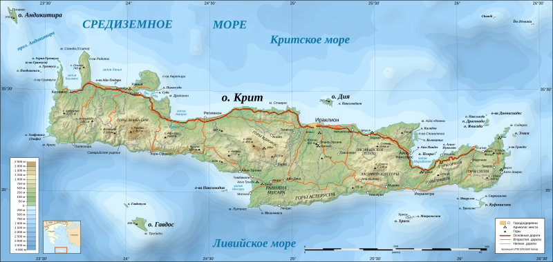
İzahCrete topographic map-ru.svg
Русский: Топографическая карта острова Крит (Греция) на русском языке.
English: Topographic map in Russian of Crete island, Greece.
UTM projection; WGS84 datum; shaded relief (composite image of N-W, W and N lightning positions) Approximate scales:
Topographic data and shore / lakes limits: 1:400,000 (accuracy: about 100 m) ;
Bathymetry: 1:14,800,000 (accuracy: about 3,700 m) ;
Note: The shaded relief is a raster image embedded in the SVG file.
Tarix
Mənbə
Own work;
Topography: NASA Shuttle Radar Topography Mission (SRTM3 v.2) data (public domain) edited with 3DEM and dlgv32 Pro and vectorized with Inkscape;
Bathymetry: USGS ETOPO2v2;
References used for the additional data:
Demis (see the approval e-mail and the Demis forum);
ViaMichelin;
Map from Castello Hotels.com;
Locator map: Image:Map_Greece_expansion_1832-1947-fr.svg (modified) created by Historicair;
Müəllif
Eric Gaba (Sting); User:Переход Артур (translation)
Digər versiyalar
Derivative works of this file:
Crete topographic map-ru.jpeg
Crete topographic map-uk.svg
[redaktə]
Topographic – SVG – French (original)
Topographic – SVG – Italian
Topographic – SVG – Russian
Topographic map of archaeological sites of Crete – SVG – Russian
Topographic – SVG – Ukranian
Topographic – raster – French
Topographic – raster – 日本語
Relief (raster background) – SVG - German
Relief (raster background) – raster - German
Relief (raster background) – SVG – French (original)
Relief (raster background) – SVG - Ukrainian
Relief (raster background) – SVG - Português
Archaeological map – French
Archaeological map – Russian
Only with shaded relief (same base map) - English
Macedonian
Greek
Hungarian
Urdu
This SVG file contains embedded text that can be translated into your language, using any capable SVG editor, text editor or the SVG Translate tool. For more information see: About translating SVG files.
Lisenziya
I, the copyright holder of this work, hereby publish it under the following licenses:
Bu sənədi GNU Azad Sənədləşdirmə Lisenziyası, Versiya 1.2 və ya Azad Proqram Fondu tərəfindən nəşr olunan hər hansı sonrakı versiya şərtlərinə əsasən dəyişməz bölmələr, ön qapaq mətnləri və arxa qapaq mətnləri olmadan köçürmək, yayımlamaq və / və ya dəyişdirmək üçün icazə verilir; Lisenziyanın bir nüsxəsi GNU Azad Sənədləşdirmə Lisenziyası adlı hissəyə daxil edilmişdir.http://www.gnu.org/copyleft/fdl.htmlGFDLGNU Free Documentation Licensetruetrue
This file is licensed under the Creative Commons Attribution-Share Alike 4.0 International, 3.0 Unported, 2.5 Generic, 2.0 Generic and 1.0 Generic license.
Azadsınız:
paylaşmaq – əsəri köçürmək, paylamaq və ötürmək üçün
remiks etmək – əsəri adaptasiya etmək
Aşağıdakı şərtlərə riayət etməklə:
istinad – Müvafiq kredit verməlisiniz, lisenziyaya bir keçid verməlisiniz və dəyişikliklərin olub olmadığını bildirməlisiniz. Bunu hər hansı bir ağlabatan şəkildə edə bilərsiniz, ancaq lisenziyalaşdırıcının sizi və ya istifadənizi təsdiqləməsini təklif edən bir şəkildə deyil.
bənzər paylaşma – Əsəri remix edirsinizsə, dəyişdirirsinizsə və ya üzərində iş aparırsınızsa, öz töhfələrinizi orijinalda olduğu kimi eyni və ya uyğun lisenziya altında yayımlamalısınız.
Bu faylda fotoaparat və ya skanerlə əlavə olunmuş məlumatlar var. Əgər fayl sonradan redaktə olunubsa, bəzi parametrlər bu şəkildə göstərilənlərdən fərqli ola bilər.
Genişlik
3370
Hündürlük
1600
Yanvar 16, 2023
fayl, crete, topographic, fayl, faylın, tarixçəsi, istifadə, edilən, səhifələr, faylın, qlobal, istifadəsi, metaməlumatlarbu, faylın, formatındakı, görünüşünün, ölçüsü, piksel, digər, ölçülər, piksel, piksel, piksel, piksel, piksel, piksel, faylın, orijinalı, . Fayl Faylin tarixcesi Istifade edilen sehifeler Faylin qlobal istifadesi MetamelumatlarBu SVG faylin PNG formatindaki bu gorunusunun olcusu 800 380 piksel Diger olculer 320 152 piksel 640 304 piksel 1 024 486 piksel 1 280 608 piksel 2 560 1 215 piksel 3 370 1 600 piksel Faylin orijinali 8206 SVG fayli nominal olaraq 3 370 1 600 piksel faylin olcusu 2 61 MB Bu fayl Vikimedia Commons dadirve diger layihelerde istifade edile biler Faylin tesvir sehifesine get Xulase Camera location35 20 00 N 25 00 00 E View this and other nearby images on OpenStreetMap35 333333 25 000000 IzahCrete topographic map ru svg Russkij Topograficheskaya karta ostrova Krit Greciya na russkom yazyke English Topographic map in Russian of Crete island Greece UTM projection WGS84 datum shaded relief composite image of N W W and N lightning positions Approximate scales Topographic data and shore lakes limits 1 400 000 accuracy about 100 m Bathymetry 1 14 800 000 accuracy about 3 700 m Note The shaded relief is a raster image embedded in the SVG file Tarix 11 oktyabr 2009Menbe Own work Topography NASA Shuttle Radar Topography Mission SRTM3 v 2 data public domain edited with 3DEM and dlgv32 Pro and vectorized with Inkscape Bathymetry USGS ETOPO2v2 References used for the additional data Demis see the approval e mail and the Demis forum ViaMichelin Map from Castello Hotels com Locator map Image Map Greece expansion 1832 1947 fr svg modified created by Historicair Muellif Eric Gaba Sting User Perehod Artur translation Diger versiyalar Derivative works of this file Crete topographic map ru jpeg Crete topographic map uk svg redakte Topographic SVG French original Topographic SVG Italian Topographic SVG Russian Topographic map of archaeological sites of Crete SVG Russian Topographic SVG Ukranian Topographic raster French Topographic raster 日本語Relief raster background SVG German Relief raster background raster German Relief raster background SVG French original Relief raster background SVG Ukrainian Relief raster background SVG PortuguesArchaeological map French Archaeological map RussianOnly with shaded relief same base map English Macedonian Greek Hungarian Urdu This SVG file contains embedded text that can be translated into your language using any capable SVG editor text editor or the SVG Translate tool For more information see About translating SVG files Lisenziya I the copyright holder of this work hereby publish it under the following licenses Bu senedi GNU Azad Senedlesdirme Lisenziyasi Versiya 1 2 ve ya Azad Proqram Fondu terefinden nesr olunan her hansi sonraki versiya sertlerine esasen deyismez bolmeler on qapaq metnleri ve arxa qapaq metnleri olmadan kocurmek yayimlamaq ve ve ya deyisdirmek ucun icaze verilir Lisenziyanin bir nusxesi GNU Azad Senedlesdirme Lisenziyasi adli hisseye daxil edilmisdir http www gnu org copyleft fdl html GFDL GNU Free Documentation License true trueThis file is licensed under the Creative Commons Attribution Share Alike 4 0 International 3 0 Unported 2 5 Generic 2 0 Generic and 1 0 Generic license Azadsiniz paylasmaq eseri kocurmek paylamaq ve oturmek ucun remiks etmek eseri adaptasiya etmek Asagidaki sertlere riayet etmekle istinad Muvafiq kredit vermelisiniz lisenziyaya bir kecid vermelisiniz ve deyisikliklerin olub olmadigini bildirmelisiniz Bunu her hansi bir aglabatan sekilde ede bilersiniz ancaq lisenziyalasdiricinin sizi ve ya istifadenizi tesdiqlemesini teklif eden bir sekilde deyil benzer paylasma Eseri remix edirsinizse deyisdirirsinizse ve ya uzerinde is aparirsinizsa oz tohfelerinizi orijinalda oldugu kimi eyni ve ya uygun lisenziya altinda yayimlamalisiniz https creativecommons org licenses by sa 4 0 CC BY SA 4 0 Creative Commons Attribution Share Alike 4 0 true trueIstediyiniz lisenziyani sece bilersiniz CaptionsazerbaycancaAdd a one line explanation of what this file representsItems portrayed in this filetesvir edircopyright status ingiliscopyrighted ingilislisenziyaGNU Free Documentation License version 1 2 or later ingilisCreative Commons Attribution ShareAlike 2 5 Generic ingilisCreative Commons Attribution ShareAlike 3 0 Unported ingilisCreative Commons Attribution ShareAlike 4 0 International ingilisCreative Commons Attribution ShareAlike 2 0 Generic ingilisCreative Commons Attribution ShareAlike 1 0 Generic ingilisyaranma tarixi11 oktyabr 2009coordinates of the point of view ingilis35 19 59 999 N 25 0 0 000 E Faylin tarixcesi Faylin evvelki versiyasini gormek ucun gun tarix bolmesindeki tarixlere klikleyin Tarix VaxtKicik sekilOlculerIstifadeciSerh indiki10 33 10 mart 20123 370 1 600 2 61 MB Insider proliv Andikitira 10 34 11 oktyabr 20093 370 1 600 2 6 MB Perehod Artur int filedesc Location 35 20 00 N 25 00 00 E scale 2000000 lt br gt Information Description ru Topograficheskaya karta ostrova ru Krit ru Greciya na russkom yazyke en Topograp Istifade edilen sehifeler Bu sekile olan kecidler Andikitira bogazi Faylin qlobal istifadesi Bu fayl asagidaki vikilerde istifade olunur mhr wikipedia org layihesinde istifadesi Krit ru wikipedia org layihesinde istifadesi Krit Kladu Evangeliya ru wiktionary org layihesinde istifadesi Krit tt wikipedia org layihesinde istifadesi KritMetamelumatlar Bu faylda fotoaparat ve ya skanerle elave olunmus melumatlar var Eger fayl sonradan redakte olunubsa bezi parametrler bu sekilde gosterilenlerden ferqli ola biler Genislik3370Hundurluk1600 Menbe https az wikipedia org wiki Fayl Crete topographic map ru svg, wikipedia, oxu, kitab, kitabxana, axtar, tap, hersey,
ne axtarsan burda
, en yaxsi meqale sayti, meqaleler, kitablar, oyrenmek, wiki, bilgi, tarix, seks, porno, indir, yukle, sex, azeri sex, azeri, seks yukle, sex yukle, izle, seks izle, porno izle, mobil seks, telefon ucun, chat, azeri chat, tanisliq, tanishliq, azeri tanishliq, sayt, medeni, medeni saytlar, chatlar, mekan, tanisliq mekani, mekanlari, yüklə, pulsuz, pulsuz yüklə, mp3, video, mp4, 3gp, jpg, jpeg, gif, png, şəkil, muisiqi, mahnı, kino, film, kitab, oyun, oyunlar.