Bu fayl "Vikimedia Commons"dadır və digər layihələrdə istifadə edilə bilər.
Faylın təsvir səhifəsinə get
Xülasə
İzahClimate maps of Iran (Köppen-Geiger).png
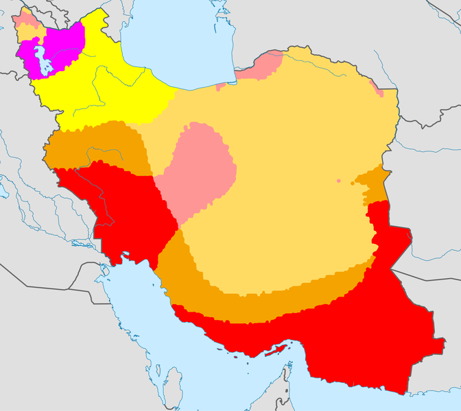
English: Climate map of Iran, using the Köppen-Geiger climate classification
Tarix
(UTC)
Mənbə
This file was derived from:
World Köppen Map.png:
Iran location map.svg:
Müəllif
World Köppen Map.png: Peel, M. C., Finlayson, B. L., and McMahon, T. A. (University of Melbourne)
Iran_location_map.svg: Uwe Dedering
derivative work: Underlying lk
BWh: Hot desert climate
Bwk: Cold desert climate
Bsh: Hot semi-arid climate
Bsk: Cold semi-arid climate
Csa: Hot summer mediterranean climate
Dsa: Hot dry summer continental climate/mediterranean continental climate
Lisenziya
Bu fayl Creative Commons Attribution-Share Alike 3.0 Sinqapur lisenziyası altında yayımlanır.
Azadsınız:
paylaşmaq – əsəri köçürmək, paylamaq və ötürmək üçün
remiks etmək – əsəri adaptasiya etmək
Aşağıdakı şərtlərə riayət etməklə:
istinad – Müvafiq kredit verməlisiniz, lisenziyaya bir keçid verməlisiniz və dəyişikliklərin olub olmadığını bildirməlisiniz. Bunu hər hansı bir ağlabatan şəkildə edə bilərsiniz, ancaq lisenziyalaşdırıcının sizi və ya istifadənizi təsdiqləməsini təklif edən bir şəkildə deyil.
bənzər paylaşma – Əsəri remix edirsinizsə, dəyişdirirsinizsə və ya üzərində iş aparırsınızsa, öz töhfələrinizi orijinalda olduğu kimi eyni və ya uyğun lisenziya altında yayımlamalısınız.
This image is a derivative work of the following images:
File:World Köppen Map.png licensed with Cc-by-sa-3.0
2011-03-13T12:13:30Z Maphobbyist 4231x2804 (1168443 Bytes) Painted the Caspian Sea as white as it should have been, because the Köppen system is based on the concept that climate types are correlated with the natural vegetation. Thus with Köppen, climate zone boundaries have been s
2010-03-05T23:41:54Z Aiyizo 4231x2804 (344162 Bytes) Cropped white space, compressed with pngout. I've also converted the image to indexed mode with an optimal 64 color palette. This introduces minor alaising effects to the region edges, but it gives a massive reduction in fi
2007-10-12T22:05:31Z Jeroen 6708x4443 (3366169 Bytes) Citation: '''Peel, M. C., Finlayson, B. L., and McMahon, T. A.: Updated world map of the Köppen-Geiger climate classification, Hydrol. Earth Syst. Sci., 11, 1633-1644, 2007.''' {{Information |Description= Updated world map
File:Iran_location_map.svg licensed with Cc-by-sa-3.0, GFDL
2013-04-15T17:55:21Z NordNordWest 1200x1071 (306314 Bytes) according to http://images.persianblog.ir/516041_B0b76ypr.jpg + Tabas -> South Khorasan province
2013-04-12T17:40:10Z Yamaha5 1200x1071 (655114 Bytes) Reverted to version as of 20:08, 11 July 2010
2013-04-12T17:38:55Z Yamaha5 1200x1071 (655114 Bytes) Reverted to version as of 20:08, 11 July 2010 in all maps khorasan is like past!
2010-07-11T20:08:23Z Uwe Dedering 1200x1071 (655114 Bytes) 31. province Alborz
2010-02-18T17:44:29Z Uwe Dedering 1200x1071 (721726 Bytes) Bahrain above water, no disputed countries
2010-02-18T13:00:48Z Uwe Dedering 1200x1071 (725716 Bytes) {{Information |Description={{en|1=Location map of Iran. Equirectangular projection. Strechted by 118.0%. Geographic limits of the map: * N: 40.0° N * S: 24.5° N * W: 43.5° E * E: 64.0° E Made with Natural Earth. Fre
Uploaded with derivativeFX
Captions
Add a one-line explanation of what this file represents
Items portrayed in this file
təsvir edir
copyright status ingilis
copyrighted ingilis
lisenziya
Creative Commons Attribution-ShareAlike 3.0 Unported ingilis
Faylın tarixçəsi
Faylın əvvəlki versiyasını görmək üçün gün/tarix bölməsindəki tarixlərə klikləyin.
Bu faylda fotoaparat və ya skanerlə əlavə olunmuş məlumatlar var. Əgər fayl sonradan redaktə olunubsa, bəzi parametrlər bu şəkildə göstərilənlərdən fərqli ola bilər.
Üfüqi xətt
28,35 dpc
Şaquli xətt
28,35 dpc
Aprel 26, 2023
fayl, climate, maps, iran, köppen, geiger, fayl, faylın, tarixçəsi, fayl, keçidləri, faylın, qlobal, istifadəsi, metaməlumatlarsınaq, göstərişi, ölçüsü, piksel, digər, ölçülər, piksel, piksel, piksel, piksel, piksel, faylın, orijinalı, 8206, piksel, fayl, həcm. Fayl Faylin tarixcesi Fayl kecidleri Faylin qlobal istifadesi MetamelumatlarSinaq gosterisi olcusu 672 600 piksel Diger olculer 269 240 piksel 538 480 piksel 861 768 piksel 1 147 1 024 piksel 2 000 1 785 piksel Faylin orijinali 8206 2 000 1 785 piksel fayl hecmi 312 KB MIME novu image png Bu fayl Vikimedia Commons dadirve diger layihelerde istifade edile biler Faylin tesvir sehifesine get Xulase IzahClimate maps of Iran Koppen Geiger png English Climate map of Iran using the Koppen Geiger climate classification Tarix 21 iyun 2013 20 36 UTC Menbe This file was derived from World Koppen Map png nbsp Iran location map svg nbsp Muellif World Koppen Map png Peel M C Finlayson B L and McMahon T A University of Melbourne Iran location map svg Uwe Dedering derivative work Underlying lk nbsp BWh Hot desert climate nbsp Bwk Cold desert climate nbsp Bsh Hot semi arid climate nbsp Bsk Cold semi arid climate nbsp Csa Hot summer mediterranean climate nbsp Dsa Hot dry summer continental climate mediterranean continental climate Lisenziya Bu fayl Creative Commons Attribution Share Alike 3 0 Sinqapur lisenziyasi altinda yayimlanir Azadsiniz paylasmaq eseri kocurmek paylamaq ve oturmek ucun remiks etmek eseri adaptasiya etmek Asagidaki sertlere riayet etmekle istinad Muvafiq kredit vermelisiniz lisenziyaya bir kecid vermelisiniz ve deyisikliklerin olub olmadigini bildirmelisiniz Bunu her hansi bir aglabatan sekilde ede bilersiniz ancaq lisenziyalasdiricinin sizi ve ya istifadenizi tesdiqlemesini teklif eden bir sekilde deyil benzer paylasma Eseri remix edirsinizse deyisdirirsinizse ve ya uzerinde is aparirsinizsa oz tohfelerinizi orijinalda oldugu kimi eyni ve ya uygun lisenziya altinda yayimlamalisiniz https creativecommons org licenses by sa 3 0 CC BY SA 3 0 Creative Commons Attribution Share Alike 3 0 true true Orijinal yukleme gundeliyi This image is a derivative work of the following images File World Koppen Map png licensed with Cc by sa 3 0 2011 03 13T12 13 30Z Maphobbyist 4231x2804 1168443 Bytes Painted the Caspian Sea as white as it should have been because the Koppen system is based on the concept that climate types are correlated with the natural vegetation Thus with Koppen climate zone boundaries have been s 2010 03 05T23 41 54Z Aiyizo 4231x2804 344162 Bytes Cropped white space compressed with pngout I ve also converted the image to indexed mode with an optimal 64 color palette This introduces minor alaising effects to the region edges but it gives a massive reduction in fi 2007 10 12T22 35 59Z Jeroen 4250x2815 2188412 Bytes 2007 10 12T22 05 31Z Jeroen 6708x4443 3366169 Bytes Citation Peel M C Finlayson B L and McMahon T A Updated world map of the Koppen Geiger climate classification Hydrol Earth Syst Sci 11 1633 1644 2007 Information Description Updated world map File Iran location map svg licensed with Cc by sa 3 0 GFDL 2013 04 15T17 55 21Z NordNordWest 1200x1071 306314 Bytes according to http images persianblog ir 516041 B0b76ypr jpg Tabas gt South Khorasan province 2013 04 12T17 40 10Z Yamaha5 1200x1071 655114 Bytes Reverted to version as of 20 08 11 July 2010 2013 04 12T17 38 55Z Yamaha5 1200x1071 655114 Bytes Reverted to version as of 20 08 11 July 2010 in all maps khorasan is like past 2013 03 17T11 30 56Z NordNordWest 1200x1071 301415 Bytes upd 2010 07 11T20 08 23Z Uwe Dedering 1200x1071 655114 Bytes 31 province Alborz 2010 02 18T17 44 29Z Uwe Dedering 1200x1071 721726 Bytes Bahrain above water no disputed countries 2010 02 18T13 00 48Z Uwe Dedering 1200x1071 725716 Bytes Information Description en 1 Location map of Iran Equirectangular projection Strechted by 118 0 Geographic limits of the map N 40 0 N S 24 5 N W 43 5 E E 64 0 E Made with Natural Earth Fre Uploaded with derivativeFXCaptionsazerbaycancaAdd a one line explanation of what this file representsItems portrayed in this filetesvir edircopyright status nbsp ingiliscopyrighted nbsp ingilislisenziyaCreative Commons Attribution ShareAlike 3 0 Unported nbsp ingilis Faylin tarixcesi Faylin evvelki versiyasini gormek ucun gun tarix bolmesindeki tarixlere klikleyin Tarix VaxtKicik sekilOlculerIstifadeciSerh indiki20 39 21 iyun 20132 000 1 785 312 KB Underlying lk int filedesc Information Description en 1 Climate map of Iran using the Koppen Geiger climate classification Source Derived from World Koppen Map png Iran location map svg display 50 Date 2013 06 21 20 36 UTC Author File Fayl kecidleri Bu sekile olan kecidler Iranin iqlimi Faylin qlobal istifadesi Bu fayl asagidaki vikilerde istifade olunur nn wikipedia org layihesinde istifadesi Iran Iransk geografi te wikipedia org layihesinde istifadesi ఇర న Metamelumatlar Bu faylda fotoaparat ve ya skanerle elave olunmus melumatlar var Eger fayl sonradan redakte olunubsa bezi parametrler bu sekilde gosterilenlerden ferqli ola biler Ufuqi xett28 35 dpcSaquli xett28 35 dpc Menbe https az wikipedia org wiki Fayl Climate maps of Iran Koppen Geiger png, wikipedia, oxu, kitab, kitabxana, axtar, tap, hersey,
ne axtarsan burda
, en yaxsi meqale sayti, meqaleler, kitablar, oyrenmek, wiki, bilgi, tarix, seks, porno, indir, yukle, sex, azeri sex, azeri, seks yukle, sex yukle, izle, seks izle, porno izle, mobil seks, telefon ucun, chat, azeri chat, tanisliq, tanishliq, azeri tanishliq, sayt, medeni, medeni saytlar, chatlar, mekan, tanisliq mekani, mekanlari, yüklə, pulsuz, pulsuz yüklə, mp3, video, mp4, 3gp, jpg, jpeg, gif, png, şəkil, muisiqi, mahnı, kino, film, kitab, oyun, oyunlar.