Bu fayl "Vikimedia Commons"dadır və digər layihələrdə istifadə edilə bilər.
təsvir səhifəsi
Faylın təsvir səhifəsinə get
Artist
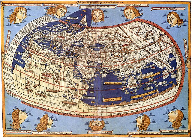
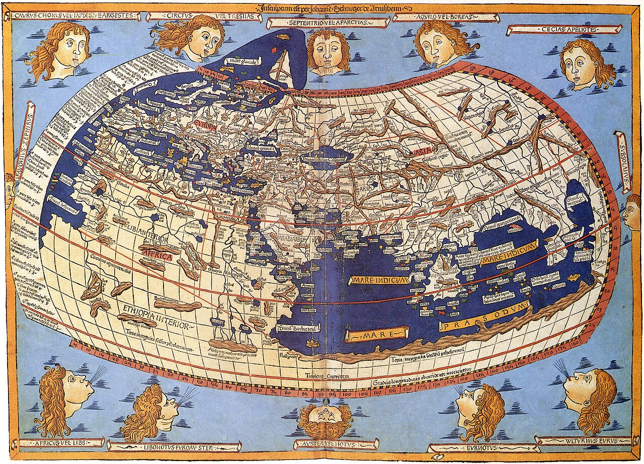
Lord Nicolas the German (Donnus Nicholas Germanus), cartographer Johann the Blockcutter of Armsheim (Johannes Schnitzer or Johannes de Armssheim), engraver
Müəllif
Ptolemy Jacobus Angelus, translator
İzah
English: The world map from Leinhart Holle's 1482 edition of Nicolaus Germanus's emendations to Jacobus Angelus's 1406 Latin translation of Maximus Planudes's late-13th century rediscovered Greek manuscripts of Ptolemy's 2nd-century Geography.
Tarix
1482
date QS:P571,+1482-00-00T00:00:00Z/9
Source/Photographer
Decorative Maps by Roderick Barron - ISBN 1851702989
İcazə (Faylın təkrar istifadəsi)
Public domainPublic domainfalsefalse
https://creativecommons.org/publicdomain/mark/1.0/PDMCreative Commons Public Domain Mark 1.0falsefalse
Digər versiyalar
Captions
Add a one-line explanation of what this file represents
A medieval depiction of the Ecumene
Una representación medieval del Ecúmene
Items portrayed in this file
təsvir edir
coğrafi xəritə
world map ingilis
MIME type ingilis
image/jpeg
Faylın tarixçəsi
Faylın əvvəlki versiyasını görmək üçün gün/tarix bölməsindəki tarixlərə klikləyin.
{{Information |Description=Claudius Ptolemy: The World |Source=Scanned by Scott Ehardt from Decorative Maps by Roderick Barron - ISBN 1851702989 |Date=1482 |Author=Johannes Schnitzer, engraver<br>Claudius Ptolemy, cartographer |Permissio
Bu faylda fotoaparat və ya skanerlə əlavə olunmuş məlumatlar var. Əgər fayl sonradan redaktə olunubsa, bəzi parametrlər bu şəkildə göstərilənlərdən fərqli ola bilər.
Müəllif
Picasa 2.6
Fevral 13, 2024
fayl, claudius, ptolemy, world, fayl, faylın, tarixçəsi, fayl, keçidləri, faylın, qlobal, istifadəsi, metaməlumatlarsınaq, göstərişi, ölçüsü, piksel, digər, ölçülər, piksel, piksel, piksel, piksel, piksel, piksel, faylın, orijinalı, 8206, piksel, fayl, həcmi, . Fayl Faylin tarixcesi Fayl kecidleri Faylin qlobal istifadesi MetamelumatlarSinaq gosterisi olcusu 800 576 piksel Diger olculer 320 230 piksel 640 461 piksel 1 024 737 piksel 1 280 922 piksel 2 560 1 843 piksel 8 073 5 813 piksel Faylin orijinali 8206 8 073 5 813 piksel fayl hecmi 18 03 MB MIME novu image jpeg Bu fayl Vikimedia Commons dadirve diger layihelerde istifade edile biler tesvir sehifesi Faylin tesvir sehifesine get Artist Lord Nicolas the German Donnus Nicholas Germanus cartographerJohann the Blockcutter of Armsheim Johannes Schnitzer or Johannes de Armssheim engraver Muellif PtolemyJacobus Angelus translator Izah English The world map from Leinhart Holle s 1482 edition of Nicolaus Germanus s emendations to Jacobus Angelus s 1406 Latin translation of Maximus Planudes s late 13th century rediscovered Greek manuscripts of Ptolemy s 2nd century Geography Tarix 1482date QS P571 1482 00 00T00 00 00Z 9 Source Photographer Decorative Maps by Roderick Barron ISBN nbsp 1851702989 Icaze Faylin tekrar istifadesi Public domain Public domain false false This work is in the public domain in its country of origin and other countries and areas where the copyright term is the author s life plus 100 years or fewer You must also include a United States public domain tag to indicate why this work is in the public domain in the United States This file has been identified as being free of known restrictions under copyright law including all related and neighboring rights https creativecommons org publicdomain mark 1 0 PDM Creative Commons Public Domain Mark 1 0 false false Diger versiyalarCaptionsazerbaycancaAdd a one line explanation of what this file representsingilisA medieval depiction of the EcumeneispanUna representacion medieval del EcumeneItems portrayed in this filetesvir edircografi xeriteworld map nbsp ingilisMIME type nbsp ingilisimage jpeg Faylin tarixcesi Faylin evvelki versiyasini gormek ucun gun tarix bolmesindeki tarixlere klikleyin Tarix VaxtKicik sekilOlculerIstifadeciSerh indiki08 26 31 oktyabr 20238 073 5 813 18 03 MB OnlySlightlyDampReverted to version as of 03 58 3 July 2007 UTC 08 08 22 oktyabr 20238 226 5 919 19 53 MB ShekishekieyReverted to version as of 03 54 3 July 2007 UTC 03 58 3 iyul 20078 073 5 813 18 03 MB SCEhardtcropped amp rotated 03 54 3 iyul 20078 226 5 919 19 53 MB SCEhardt Information Description Claudius Ptolemy The World Source Scanned by Scott Ehardt from Decorative Maps by Roderick Barron ISBN 1851702989 Date 1482 Author Johannes Schnitzer engraver lt br gt Claudius Ptolemy cartographer Permissio Fayl kecidleri Asagidaki sehife bu fayli istifade edir Oykumena Faylin qlobal istifadesi Bu fayl asagidaki vikilerde istifade olunur ar wikipedia org layihesinde istifadesi الجغرافية بطليموس be wikipedia org layihesinde istifadesi Ajkumena bg wikipedia org layihesinde istifadesi Veliki geografski otkritiya Karta na Ptolemej bh wikipedia org layihesinde istifadesi नक श प र ज क शन bn wikipedia org layihesinde istifadesi ম নচ ত র ঙ কনব দ য ম নচ ত র অভ ক ষ প br wikipedia org layihesinde istifadesi Kartennouriezh ca wikipedia org layihesinde istifadesi Claudi Ptolemeu Viquiprojecte ICC Analisi Tetrabiblos de wikipedia org layihesinde istifadesi Theorie der muslimischen Entdeckung Amerikas el wikipedia org layihesinde istifadesi Klaydios Ptolemaios en wikipedia org layihesinde istifadesi Cartography Ptolemy Terra Australis Map projection History of geodesy Ecumene Tetrabiblos User Peter Mercator Map gallery Mercator 1569 world map Ancient Greece Ancient India relations Portal Geodesy eo wikipedia org layihesinde istifadesi Jacques Cartier es wikipedia org layihesinde istifadesi Antartida Claudio Ptolomeo Tetrabiblos eu wikipedia org layihesinde istifadesi Euskal Herria erromatarren garaian fa wikipedia org layihesinde istifadesi نقشه نگاری سیستم تصویر نقشه یکمان fr wikipedia org layihesinde istifadesi Claude Ptolemee Discussion Antarctique Monde univers Antarctique Departement des cartes et plans de la Bibliotheque nationale de France Discussion Projet Monde polaire Archives Utilisateur Witcher of Izalith Galeries d Izalith fr wikiversity org layihesinde istifadesi Recherche Les abolitions des traites et des esclavages Annexe Chronologie Utilisateur Ambre Troizat L esclave amp son reflet fy wikipedia org layihesinde istifadesi Kartografy ga wikipedia org layihesinde istifadesi Teilgean learscaile hi wikipedia org layihesinde istifadesi म नच त रकल hu wikipedia org layihesinde istifadesi Terkepeszet hy wikipedia org layihesinde istifadesi Օյկումենա id wikipedia org layihesinde istifadesi Kartografi Oikumene incubator wikimedia org layihesinde istifadesi Wp rki တ လမ Ptolemaeus is wikipedia org layihesinde istifadesi Kortavorpun Bu faylin qlobal istifadesine baxin Metamelumatlar Bu faylda fotoaparat ve ya skanerle elave olunmus melumatlar var Eger fayl sonradan redakte olunubsa bezi parametrler bu sekilde gosterilenlerden ferqli ola biler MuellifPicasa 2 6 Menbe https az wikipedia org wiki Fayl Claudius Ptolemy The World jpg, wikipedia, oxu, kitab, kitabxana, axtar, tap, hersey,
ne axtarsan burda
, en yaxsi meqale sayti, meqaleler, kitablar, oyrenmek, wiki, bilgi, tarix, seks, porno, indir, yukle, sex, azeri sex, azeri, seks yukle, sex yukle, izle, seks izle, porno izle, mobil seks, telefon ucun, chat, azeri chat, tanisliq, tanishliq, azeri tanishliq, sayt, medeni, medeni saytlar, chatlar, mekan, tanisliq mekani, mekanlari, yüklə, pulsuz, pulsuz yüklə, mp3, video, mp4, 3gp, jpg, jpeg, gif, png, şəkil, muisiqi, mahnı, kino, film, kitab, oyun, oyunlar.