Bu fayl "Vikimedia Commons"dadır və digər layihələrdə istifadə edilə bilər.
təsvir səhifəsi
Faylın təsvir səhifəsinə get
Xülasə
İzahCape Cod - Landsat 7.jpg
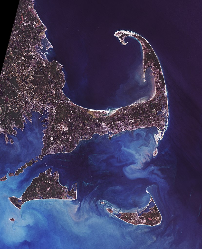
Landsat 7 image of Cape Cod, Massachusetts, 28.5 meter resolution. Based on Global Orthorectified Landsat dataset (ETM+); WRS_PATH 11, WRS_ROW 31. Generated using "true-color" combination of bands 3, 2, & 1 as R, G, B respectively. Color curves enhanced in the Gimp.
English: Cape Cod (or simply The Cape) is an arm-shaped peninsula forming the Easternmost portion of the Commonwealth of Massachusetts, USA, in the Northeastern United States. It is coextensive with Barnstable County. Although Cape Cod was originally connected to the mainland, the Cape Cod Canal, completed in 1914, effectively transformed Cape Cod into a large island.
Français : Le cap Cod (le cap aux morues), en anglais Cape Cod, est un cap ou une presqu'île sur la côte Est des États-Unis. Il se trouve dans le sud-est de l'État du Massachusetts.
Deutsch: Cape Cod (deutsch: Kap Kabeljau) ist eine 1.033 km² große Halbinsel im Südosten von Massachusetts in den USA. Im Jahre 1914 wurde ein Kanal gebaut. Die extrem langgestreckte Halbinsel wurde somit vom Festland getrennt, und die Durchfahrt vom Cape Cod Bay zum Atlantik erleichtert.
Nederlands: Cape Cod is oorspronkelijk een schiereiland aan de kust van Massachusetts. Eigenlijk is het nu een eiland omdat een kanaal het scheidt van het vasteland. Cape Cod betekent zoiets als 'kaap van de kabeljauw'. Het schiereiland kreeg deze naam al van de Europeanen in de vroege 17e eeuw toen er nog geen sprake van kolonisatie was. Er waren toen behalve bij Newfoundland ook al enorm rijke visgronden van kabeljauw bekend in de buurt van Cape Cod. Ieder jaar kwamen er grote vissersvloten uit Europa om hier te vissen. Later bleven sommige vissers het hele jaar aanwezig en vestigden zich ook op Cape Cod. Tegenwoordig is er nog steeds commerciële visserij maar die heeft het moeilijk omdat door overbevissing nog maar weinig kabeljauw is overgebleven op de eens zo rijke visgronden. Door zeebiologen wordt zelfs gevreesd dat de kabeljauw zich niet meer kan herstellen.
Norsk bokmål: Cape Cod (1033 km²) er en armformet halvøy som utgjør den østligste delen av staten Massachusetts, nordøst i Amerikas forente stater. Den er identisk med Barnstable County. Selv om Cape Cod opprinnelig hang sammen med fastlandet, ble den første Cape Cod-kanal fullført i 1914 og forandret Cape Cod i realiteten til en stor øy.
Polski: Cape Cod, przez miejscową ludność nazywany The Cape - półwysep w kształcie ramienia, położony w USA, w stanie Massachusetts w Nowej Anglii. Jego powierzchnia to 1033 km². Stanowi główną część hrabstwa Barnstable. Półwysep jest najbardziej na wschód wysuniętą częścią stanu Massachusetts. W roku 1914 ukończono budowę kanału, który oddzielił półwysep od stałego lądu. Słowo cod w języku angielskim znaczy dorsz, zaś cape - przylądek, a nazwę, nawiązującą do obfitości tych ryb w tym terenie, nadał mu podróżnik Bartholomew Gosnold w roku 1602
Slovenščina: Cape Cod je polotok v severovzhodni ameriški zvezni državi Massachusetts. Razteza se na površini 1033 km². Čeprav je bil prvotno povezan s kopnim, je leta 1914 po izgradnji kanala Cape Cod pravzaprav postal velik otok.
Svenska: Cape Cod är en långsmal halvö vid Atlantens kust i Massachusetts, USA.
{{de|'''Cape Cod''' (deutsch: ''Kap Kabeljau'') ist eine 1.033 km² große de:Halbinsel im Südosten von de:Massachusetts in den de:USA. Im Jahre de:1914 wurde ein Kanal gebaut. Die extrem langgestreckte H
fayl, cape, landsat, fayl, faylın, tarixçəsi, fayl, keçidləri, faylın, qlobal, istifadəsisınaq, göstərişi, ölçüsü, piksel, digər, ölçülər, piksel, piksel, piksel, piksel, piksel, piksel, faylın, orijinalı, 8206, piksel, fayl, həcmi, mime, növü, image, jpeg, fa. Fayl Faylin tarixcesi Fayl kecidleri Faylin qlobal istifadesiSinaq gosterisi olcusu 485 599 piksel Diger olculer 194 240 piksel 388 480 piksel 622 768 piksel 829 1 024 piksel 1 658 2 048 piksel 3 400 4 200 piksel Faylin orijinali 8206 3 400 4 200 piksel fayl hecmi 3 85 MB MIME novu image jpeg Bu fayl Vikimedia Commons dadirve diger layihelerde istifade edile biler tesvir sehifesi Faylin tesvir sehifesine get Xulase IzahCape Cod Landsat 7 jpg Landsat 7 image of Cape Cod Massachusetts 28 5 meter resolution Based on Global Orthorectified Landsat dataset ETM WRS PATH 11 WRS ROW 31 Generated using true color combination of bands 3 2 amp 1 as R G B respectively Color curves enhanced in the Gimp English Cape Cod or simply The Cape is an arm shaped peninsula forming the Easternmost portion of the Commonwealth of Massachusetts USA in the Northeastern United States It is coextensive with Barnstable County Although Cape Cod was originally connected to the mainland the Cape Cod Canal completed in 1914 effectively transformed Cape Cod into a large island Francais nbsp Le cap Cod le cap aux morues en anglais Cape Cod est un cap ou une presqu ile sur la cote Est des Etats Unis Il se trouve dans le sud est de l Etat du Massachusetts Deutsch Cape Cod deutsch Kap Kabeljau ist eine 1 033 km grosse Halbinsel im Sudosten von Massachusetts in den USA Im Jahre 1914 wurde ein Kanal gebaut Die extrem langgestreckte Halbinsel wurde somit vom Festland getrennt und die Durchfahrt vom Cape Cod Bay zum Atlantik erleichtert Nederlands Cape Cod is oorspronkelijk een schiereiland aan de kust van Massachusetts Eigenlijk is het nu een eiland omdat een kanaal het scheidt van het vasteland Cape Cod betekent zoiets als kaap van de kabeljauw Het schiereiland kreeg deze naam al van de Europeanen in de vroege 17e eeuw toen er nog geen sprake van kolonisatie was Er waren toen behalve bij Newfoundland ook al enorm rijke visgronden van kabeljauw bekend in de buurt van Cape Cod Ieder jaar kwamen er grote vissersvloten uit Europa om hier te vissen Later bleven sommige vissers het hele jaar aanwezig en vestigden zich ook op Cape Cod Tegenwoordig is er nog steeds commerciele visserij maar die heeft het moeilijk omdat door overbevissing nog maar weinig kabeljauw is overgebleven op de eens zo rijke visgronden Door zeebiologen wordt zelfs gevreesd dat de kabeljauw zich niet meer kan herstellen Norsk bokmal Cape Cod 1033 km er en armformet halvoy som utgjor den ostligste delen av staten Massachusetts nordost i Amerikas forente stater Den er identisk med Barnstable County Selv om Cape Cod opprinnelig hang sammen med fastlandet ble den forste Cape Cod kanal fullfort i 1914 og forandret Cape Cod i realiteten til en stor oy Polski Cape Cod przez miejscowa ludnosc nazywany The Cape polwysep w ksztalcie ramienia polozony w USA w stanie Massachusetts w Nowej Anglii Jego powierzchnia to 1033 km Stanowi glowna czesc hrabstwa Barnstable Polwysep jest najbardziej na wschod wysunieta czescia stanu Massachusetts W roku 1914 ukonczono budowe kanalu ktory oddzielil polwysep od stalego ladu Slowo cod w jezyku angielskim znaczy dorsz zas cape przyladek a nazwe nawiazujaca do obfitosci tych ryb w tym terenie nadal mu podroznik Bartholomew Gosnold w roku 1602 Slovenscina Cape Cod je polotok v severovzhodni ameriski zvezni drzavi Massachusetts Razteza se na povrsini 1033 km Ceprav je bil prvotno povezan s kopnim je leta 1914 po izgradnji kanala Cape Cod pravzaprav postal velik otok Svenska Cape Cod ar en langsmal halvo vid Atlantens kust i Massachusetts USA 中文 鳕鱼角 是 美国东北部马萨诸塞州伸入大西洋的一个半岛 面积1033平方公里 1914年 美国在该半岛与大陆连接处开掘鳕鱼角运河 使鳕鱼角实际上成为了一个岛屿 This summary was created using Commons SumItUp de Cape Cod en Cape Cod fr Cap Cod nl Cape Cod no Cape Cod pl Cape Cod sl Cape Cod sv Cape Cod zh 鳕鱼角 Tarix Data acquisition 1999 09 18 Orthorectified version produced 2002 12 29 Image created 2007 02 06 Menbe Data from USGS GloVis server http glovis usgs gov Landsat Orthorectified data generated through NASA s Commercial Remote Sensing Program Muellif Data NASA Image Dave Pape Icaze Faylin tekrar istifadesi Original data PD NASA any copyright that exists from my creation of this image is dedicated to the public domain PD SELF Camera location41 nbsp 48 nbsp 00 nbsp N 70 nbsp 14 nbsp 00 nbsp W nbsp View this and other nearby images on OpenStreetMap41 800000 70 233333 Lisenziya Public domain Public domain false false This file is in the public domain in the United States because it was solely created by NASA NASA copyright policy states that NASA material is not protected by copyright unless noted See Template PD USGov NASA copyright policy page or JPL Image Use Policy Warnings Use of NASA logos insignia and emblems is restricted per U S law 14 CFR 1221 The NASA website hosts a large number of images from the Soviet Russian space agency and other non American space agencies These are not necessarily in the public domain Materials based on Hubble Space Telescope data may be copyrighted if they are not explicitly produced by the STScI 1 See also PD Hubble and Cc Hubble The SOHO ESA amp NASA joint project implies that all materials created by its probe are copyrighted and require permission for commercial non educational use 2 Images featured on the Astronomy Picture of the Day APOD web site may be copyrighted 3 The National Space Science Data Center NSSDC site has been known to host copyrighted content Its photo gallery FAQ states that all of the images in the photo gallery are in the public domain Unless otherwise noted Public domain Public domain false false This work is based on a work in the public domain It has been digitally enhanced and or modified This derivative work has been or is hereby released into the public domain by its author Davepape This applies worldwide In some countries this may not be legally possible if so Davepape grants anyone the right to use this work for any purpose without any conditions unless such conditions are required by law CaptionsazerbaycancaAdd a one line explanation of what this file representsItems portrayed in this filetesvir edircopyright status nbsp ingiliscopyrighted dedicated to the public domain by copyright holder nbsp ingilislisenziyareleased into the public domain by the copyright holder nbsp ingiliscoordinates of the point of view nbsp ingilis41 48 0 000 N 70 13 59 999 WMIME type nbsp ingilisimage jpegchecksum nbsp ingilis094f3418406f88115fea122487a39eb270702319teyinetme usulu SHA 1 nbsp ingilisdata size nbsp ingilis4 038 119 Baythundurluyu boyu4 200 pikseleni3 400 piksel Faylin tarixcesi Faylin evvelki versiyasini gormek ucun gun tarix bolmesindeki tarixlere klikleyin Tarix VaxtKicik sekilOlculerIstifadeciSerh indiki17 44 6 fevral 20073 400 4 200 3 85 MB Davepape de 039 039 039 Cape Cod 039 039 039 deutsch 039 039 Kap Kabeljau 039 039 ist eine 1 033 km grosse de Halbinsel im Sudosten von de Massachusetts in den de USA Im Jahre de 1914 wurde ein Kanal gebaut Die extrem langgestreckte H Fayl kecidleri Asagidaki sehife bu fayli istifade edir Burun cografiya Faylin qlobal istifadesi Bu fayl asagidaki vikilerde istifade olunur ar wikipedia org layihesinde istifadesi قائمة أشباه الجزر bn wikipedia org layihesinde istifadesi অন তর প cs wikipedia org layihesinde istifadesi Lod Fortune 1621 da wikipedia org layihesinde istifadesi Kap geografi de wikipedia org layihesinde istifadesi Geographie der Vereinigten Staaten en wikipedia org layihesinde istifadesi Talk Cranberry Talk Guglielmo Marconi Talk John F Kennedy Talk Judy Blume Talk Lucretia Mott List of peninsulas Talk Vinland Talk Pilgrims Plymouth Colony Talk Nantucket Talk Hillary Clinton Talk Kim Deal Talk Joss Whedon Talk Joshua Slocum Talk John Smith explorer Talk Lymantria dispar Talk Shawn Fanning Talk Walter Cronkite Talk Judy Garland Talk George H W Bush Talk Barnstable County Massachusetts Talk Dukes County Massachusetts Talk Meg Ryan Talk RMS Olympic Talk Joseph P Kennedy Sr Talk Henry David Thoreau Talk Jacqueline Kennedy Onassis Talk Giovanni da Verrazzano Talk Minke whale Talk Samuel de Champlain Talk Moby Dick Talk Naushon Island Talk Wampanoag people Talk Patrick Bouvier Kennedy Talk Mary Jo Kopechne Talk Massachusett language Talk Cape Cod Talk Teresa Heinz Talk Humpback whale Talk Larry David Talk Fox Mulder Talk Jack Kerouac Talk Hurricane Bob Talk Mike Wallace Talk Essex whaleship Talk Jessica Dubroff Bu faylin qlobal istifadesine baxin Menbe https az wikipedia org wiki Fayl Cape Cod Landsat 7 jpg, wikipedia, oxu, kitab, kitabxana, axtar, tap, hersey,
ne axtarsan burda
, en yaxsi meqale sayti, meqaleler, kitablar, oyrenmek, wiki, bilgi, tarix, seks, porno, indir, yukle, sex, azeri sex, azeri, seks yukle, sex yukle, izle, seks izle, porno izle, mobil seks, telefon ucun, chat, azeri chat, tanisliq, tanishliq, azeri tanishliq, sayt, medeni, medeni saytlar, chatlar, mekan, tanisliq mekani, mekanlari, yüklə, pulsuz, pulsuz yüklə, mp3, video, mp4, 3gp, jpg, jpeg, gif, png, şəkil, muisiqi, mahnı, kino, film, kitab, oyun, oyunlar.