Bu fayl "Vikimedia Commons"dadır və digər layihələrdə istifadə edilə bilər.
Faylın təsvir səhifəsinə get
Xülasə
İzahC71188s5 Ant.Map Cape Adare.jpg
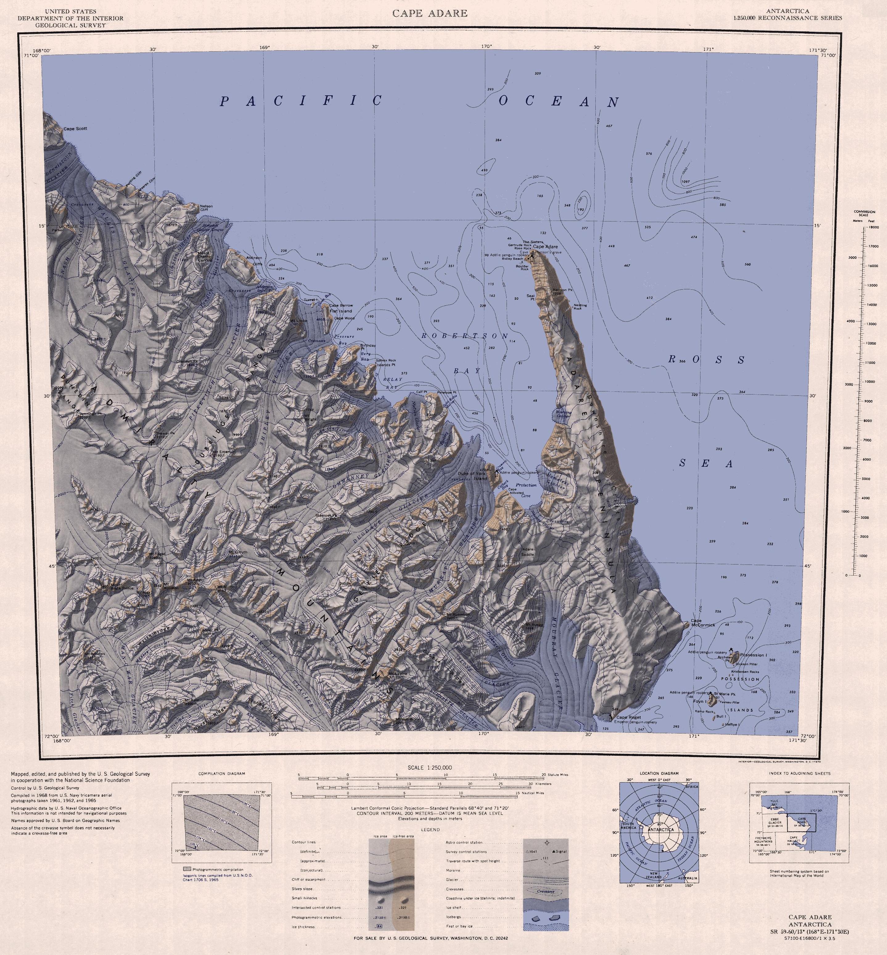
English: 1:250,000-scale topographic reconnaissance map of the Cape Adare region in Antarctica (168°E - 171°30'E, 71°S - 72°S). Mapped, edited and published by the U.S. Geological Survey in cooperation with the National Science Foundation.
Map of Antarctica by the United States Antarctic Ressource Center of the US Geological Society. {{PD-US}} Copyrights and Trademarks USGS-authored or produced data and information are in the public domain. While the content of most USGS web pages is in th
fayl, c71188s5, cape, adare, fayl, faylın, tarixçəsi, fayl, keçidləri, faylın, qlobal, istifadəsisınaq, göstərişi, ölçüsü, piksel, digər, ölçülər, piksel, piksel, piksel, piksel, piksel, piksel, faylın, orijinalı, 8206, piksel, fayl, həcmi, mime, növü, image, . Fayl Faylin tarixcesi Fayl kecidleri Faylin qlobal istifadesiSinaq gosterisi olcusu 557 599 piksel Diger olculer 223 240 piksel 446 480 piksel 714 768 piksel 952 1 024 piksel 1 903 2 048 piksel 2 877 3 096 piksel Faylin orijinali 8206 2 877 3 096 piksel fayl hecmi 1 53 MB MIME novu image jpeg Bu fayl Vikimedia Commons dadirve diger layihelerde istifade edile biler Faylin tesvir sehifesine get Xulase IzahC71188s5 Ant Map Cape Adare jpg English 1 250 000 scale topographic reconnaissance map of the Cape Adare region in Antarctica 168 E 171 30 E 71 S 72 S Mapped edited and published by the U S Geological Survey in cooperation with the National Science Foundation Tarix 1968 Menbe http usarc usgs gov drg dload shtml Muellif United States Geological Survey Icaze Faylin tekrar istifadesi Public domain Public domain false false This image is in the public domain in the United States because it only contains materials that originally came from the United States Geological Survey an agency of the United States Department of the Interior For more information see the official USGS copyright policy Bahasa Indonesia nbsp catala nbsp cestina nbsp Deutsch nbsp eesti nbsp English nbsp espanol nbsp francais nbsp galego nbsp italiano nbsp Nederlands nbsp portugues nbsp polski nbsp sicilianu nbsp suomi nbsp Tiếng Việt nbsp Turkce nbsp blgarski nbsp makedonski nbsp russkij nbsp മലയ ള nbsp 한국어 nbsp 日本語 nbsp 中文 nbsp 中文 简体 nbsp 中文 繁體 nbsp العربية nbsp فارسی nbsp Diger versiyalar Derivative works of this file Adare Peninsula map jpg Possession Islands map jpgCaptionsazerbaycancaAdd a one line explanation of what this file representsItems portrayed in this filetesvir ediryaranma tarixi1968 Faylin tarixcesi Faylin evvelki versiyasini gormek ucun gun tarix bolmesindeki tarixlere klikleyin Tarix VaxtKicik sekilOlculerIstifadeciSerh indiki12 47 26 noyabr 20152 877 3 096 1 53 MB ValeriyShObrizka zajvogo polya 16 43 3 aprel 20053 506 3 260 1 67 MB Achim RaschkaMap of Antarctica by the United States Antarctic Ressource Center of the US Geological Society PD US Copyrights and Trademarks USGS authored or produced data and information are in the public domain While the content of most USGS web pages is in th Fayl kecidleri Bu sekile olan kecidler Ader burnu Faylin qlobal istifadesi Bu fayl asagidaki vikilerde istifade olunur ar wikipedia org layihesinde istifadesi خليج روبرتسون كيب أدار ast wikipedia org layihesinde istifadesi Cabu Adare be wikipedia org layihesinde istifadesi Ader mys bg wikipedia org layihesinde istifadesi Bryag Penel Admiralti planina ceb wikipedia org layihesinde istifadesi Adare punta de wikipedia org layihesinde istifadesi Admiralitatsberge Mount Minto Dunedin Range Pennell Kuste Pressure Bay Relay Bay Mount Sabine Meares Kliff Ponting Kliff en wikipedia org layihesinde istifadesi Cape Adare Dugdale Glacier eo wikipedia org layihesinde istifadesi Kabo Adare es wikipedia org layihesinde istifadesi Carsten Borchgrevink Expedicion Southern Cross Cabo Adare fr wikipedia org layihesinde istifadesi Expedition Southern Cross Baie de Robertson Wikipedia Atelier graphique Cartes Archives mai 2015 he wikipedia org layihesinde istifadesi כף אדייר id wikipedia org layihesinde istifadesi Tanjung Adare it wikipedia org layihesinde istifadesi Capo Adare Costa di Pennell Monti dell Ammiragliato Ghiacciaio Man o War Ghiacciaio Fitch Ghiacciaio Deming Ghiacciaio Massey Ghiacciaio Moubray Ghiacciaio Slone Ghiacciaio DeAngelo Ghiacciaio Fowlie Ghiacciaio Fendley Ghiacciaio Pitkevitch Ghiacciaio Shipley Ghiacciaio Crume Ghiacciaio Ommanney Ghiacciaio Murray Isola del Duca di York Antartide Isola Flat Isola Turret Ghiacciaio Nielsen Ghiacciaio Egeberg Ghiacciaio Scott Keltie Bu faylin qlobal istifadesine baxin Menbe https az wikipedia org wiki Fayl C71188s5 Ant Map Cape Adare jpg, wikipedia, oxu, kitab, kitabxana, axtar, tap, hersey,
ne axtarsan burda
, en yaxsi meqale sayti, meqaleler, kitablar, oyrenmek, wiki, bilgi, tarix, seks, porno, indir, yukle, sex, azeri sex, azeri, seks yukle, sex yukle, izle, seks izle, porno izle, mobil seks, telefon ucun, chat, azeri chat, tanisliq, tanishliq, azeri tanishliq, sayt, medeni, medeni saytlar, chatlar, mekan, tanisliq mekani, mekanlari, yüklə, pulsuz, pulsuz yüklə, mp3, video, mp4, 3gp, jpg, jpeg, gif, png, şəkil, muisiqi, mahnı, kino, film, kitab, oyun, oyunlar.