Bu fayl "Vikimedia Commons"dadır və digər layihələrdə istifadə edilə bilər.
Faylın təsvir səhifəsinə get
Xülasə
İzahBasin of Lop Nur 90.25E, 40.10N, Kum Tagh and Astin Tagh.jpg
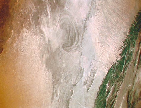
English: China, Xinjiang, desert Lop Nur. Satellite picture of the Basin of the formerly sea Lop Nur in the Desert of Lop Nur. In the foreground Kuruktagh, in the background Kumtagh and Astintagh.
Deutsch: China, Xinjiang, Wüste Lop Nor. Satellitenaufnahme von dem mittleren Teil des Seebeckens Lop Nor und der Wüste Lop Nor. Links im Vordergrund sieht man einen Teil des Gebirges Kuruktagh mit Kratern des Kernwaffentestgeländes, im Hintergrund die Hänge des Kumtagh und die Hochebene des Astintagh. Blick von Nordwesten Richtung Südosten.
Tarix
Mənbə
NASA Mission: STS047 Roll: 217 Frame: 33 Mission ID on the Film or image: STS47. File name: STS047-217-33.JPG [1]
Müəllif
NASA. Color adjusting of this image (using Adobe Photoshop 6.0): Michael Gaebler, 02. March 2006, own work, all rights released (Public domain). de: Zugrunde liegt ein noch nicht farbrichtiges Astronauten-Foto der NASA. Diese Fotografie wurde von Michael Gaebler am 02. März 2006 im RGB-Modus mit Adobe Photoshop 6.0 mit Farb- und Tonwertkorrekturen überarbeitet.
İcazə (Faylın təkrar istifadəsi)
PD-USGov-NASA
This image or video was catalogued by one of the centers of the United States National Aeronautics and Space Administration (NASA) under Photo ID: STS047-217-33.
This tag does not indicate the copyright status of the attached work. A normal copyright tag is still required.See Commons:Licensing.العربية ∙ беларуская (тарашкевіца) ∙ български ∙ català ∙ čeština ∙ dansk ∙ Deutsch ∙ English ∙ español ∙ فارسی ∙ français ∙ galego ∙ magyar ∙ հայերեն ∙ Bahasa Indonesia ∙ italiano ∙ 日本語 ∙ македонски ∙ മലയാളം ∙ Nederlands ∙ polski ∙ português ∙ русский ∙ sicilianu ∙ slovenščina ∙ Türkçe ∙ українська ∙ 简体中文 ∙ 繁體中文 ∙ +/−
Lisenziya
Public domainPublic domainfalsefalse
Captions
Add a one-line explanation of what this file represents
Items portrayed in this file
təsvir edir
yaranma tarixi
sentyabr 1992
Faylın tarixçəsi
Faylın əvvəlki versiyasını görmək üçün gün/tarix bölməsindəki tarixlərə klikləyin.
{{Information| |Description = en: China, Xinjiang, desert Lop Nur. Satellite picture of the Basin of the formerly sea Lop Nur in the desert of Lop. In the foreground Kuruktagh, in the background Kumtagh and Astintagh. de: China, Xinjiang, W�
Bu faylda fotoaparat və ya skanerlə əlavə olunmuş məlumatlar var. Əgər fayl sonradan redaktə olunubsa, bəzi parametrlər bu şəkildə göstərilənlərdən fərqli ola bilər.
Üfüqi xətt
72 dpi
Şaquli xətt
72 dpi
Aprel 05, 2023
fayl, basin, tagh, astin, tagh, fayl, faylın, tarixçəsi, fayl, keçidləri, faylın, qlobal, istifadəsi, metaməlumatlardaha, yüksək, versiyası, yoxdur, basin, tagh, astin, tagh, 8206, piksel, fayl, həcmi, mime, növü, image, jpeg, fayl, vikimedia, commons, dadırvə. Fayl Faylin tarixcesi Fayl kecidleri Faylin qlobal istifadesi MetamelumatlarDaha yuksek versiyasi yoxdur Basin of Lop Nur 90 25E 40 10N Kum Tagh and Astin Tagh jpg 8206 576 441 piksel fayl hecmi 176 KB MIME novu image jpeg Bu fayl Vikimedia Commons dadirve diger layihelerde istifade edile biler Faylin tesvir sehifesine get Xulase IzahBasin of Lop Nur 90 25E 40 10N Kum Tagh and Astin Tagh jpg English China Xinjiang desert Lop Nur Satellite picture of the Basin of the formerly sea Lop Nur in the Desert of Lop Nur In the foreground Kuruktagh in the background Kumtagh and Astintagh Deutsch China Xinjiang Wuste Lop Nor Satellitenaufnahme von dem mittleren Teil des Seebeckens Lop Nor und der Wuste Lop Nor Links im Vordergrund sieht man einen Teil des Gebirges Kuruktagh mit Kratern des Kernwaffentestgelandes im Hintergrund die Hange des Kumtagh und die Hochebene des Astintagh Blick von Nordwesten Richtung Sudosten Tarix sentyabr 1992 Menbe NASA Mission STS047 Roll 217 Frame 33 Mission ID on the Film or image STS47 File name STS047 217 33 JPG 1 Muellif NASA Color adjusting of this image using Adobe Photoshop 6 0 Michael Gaebler 02 March 2006 own work all rights released Public domain de Zugrunde liegt ein noch nicht farbrichtiges Astronauten Foto der NASA Diese Fotografie wurde von Michael Gaebler am 02 Marz 2006 im RGB Modus mit Adobe Photoshop 6 0 mit Farb und Tonwertkorrekturen uberarbeitet Icaze Faylin tekrar istifadesi PD USGov NASA This image or video was catalogued by one of the centers of the United States National Aeronautics and Space Administration NASA nbsp under Photo nbsp ID STS047 217 33 This tag does not indicate the copyright status of the attached work A normal copyright tag is still required See Commons Licensing العربية nbsp belaruskaya tarashkevica nbsp blgarski nbsp catala nbsp cestina nbsp dansk nbsp Deutsch nbsp English nbsp espanol nbsp فارسی nbsp francais nbsp galego nbsp magyar nbsp հայերեն nbsp Bahasa Indonesia nbsp italiano nbsp 日本語 nbsp makedonski nbsp മലയ ള nbsp Nederlands nbsp polski nbsp portugues nbsp russkij nbsp sicilianu nbsp slovenscina nbsp Turkce nbsp ukrayinska nbsp 简体中文 nbsp 繁體中文 nbsp Lisenziya Public domain Public domain false false This file is in the public domain in the United States because it was solely created by NASA NASA copyright policy states that NASA material is not protected by copyright unless noted See Template PD USGov NASA copyright policy page or JPL Image Use Policy Warnings Use of NASA logos insignia and emblems is restricted per U S law 14 CFR 1221 The NASA website hosts a large number of images from the Soviet Russian space agency and other non American space agencies These are not necessarily in the public domain Materials based on Hubble Space Telescope data may be copyrighted if they are not explicitly produced by the STScI 2 See also PD Hubble and Cc Hubble The SOHO ESA amp NASA joint project implies that all materials created by its probe are copyrighted and require permission for commercial non educational use 3 Images featured on the Astronomy Picture of the Day APOD web site may be copyrighted 4 The National Space Science Data Center NSSDC site has been known to host copyrighted content Its photo gallery FAQ states that all of the images in the photo gallery are in the public domain Unless otherwise noted CaptionsazerbaycancaAdd a one line explanation of what this file representsItems portrayed in this filetesvir ediryaranma tarixisentyabr 1992 Faylin tarixcesi Faylin evvelki versiyasini gormek ucun gun tarix bolmesindeki tarixlere klikleyin Tarix VaxtKicik sekilOlculerIstifadeciSerh indiki15 57 23 dekabr 2012576 441 176 KB RotatebotBot Image rotated by 90 00 42 6 mart 2006441 585 178 KB Michael Gabler Information Description en China Xinjiang desert Lop Nur Satellite picture of the Basin of the formerly sea Lop Nur in the desert of Lop In the foreground Kuruktagh in the background Kumtagh and Astintagh de China Xinjiang W Fayl kecidleri Bu sekile olan kecidler Lobnor golu Lop sehrasi Faylin qlobal istifadesi Bu fayl asagidaki vikilerde istifade olunur ar wikipedia org layihesinde istifadesi صحراء لوب بحيرة لوب نور bg wikipedia org layihesinde istifadesi Lobnor ca wikipedia org layihesinde istifadesi Lob Nor de wikipedia org layihesinde istifadesi Lop Nor en wikipedia org layihesinde istifadesi Lop Desert en wikivoyage org layihesinde istifadesi Nuclear tourism eo wikipedia org layihesinde istifadesi Lop Nor es wikipedia org layihesinde istifadesi Desierto de Lop Nor et wikipedia org layihesinde istifadesi Lop Nur gd wikipedia org layihesinde istifadesi Fasach Lop he wikipedia org layihesinde istifadesi לופ נור he wikivoyage org layihesinde istifadesi דרך המשי hi wikipedia org layihesinde istifadesi ल प न र hu wikipedia org layihesinde istifadesi Lop nor hy wikipedia org layihesinde istifadesi Լոբնոր id wikipedia org layihesinde istifadesi Gurun Lop it wikipedia org layihesinde istifadesi Deserto di Lop ka wikipedia org layihesinde istifadesi ლოპის უდაბნო kk wikipedia org layihesinde istifadesi Lobnor Sagalyk kol ko wikipedia org layihesinde istifadesi 크로라이나 lt wikipedia org layihesinde istifadesi Lobnoro dykuma mk wikipedia org layihesinde istifadesi Lop pustina nl wikipedia org layihesinde istifadesi Lob Nuur pt wikipedia org layihesinde istifadesi Deserto de Lop ru wikipedia org layihesinde istifadesi Lobnor Lop pustynya sh wikipedia org layihesinde istifadesi Lop Nor sl wikipedia org layihesinde istifadesi Lop Nor te wikipedia org layihesinde istifadesi ల ప న ర ug wikipedia org layihesinde istifadesi لوپنۇر www wikidata org layihesinde istifadesi Q319412 zh wikivoyage org layihesinde istifadesi 巴音郭楞Metamelumatlar Bu faylda fotoaparat ve ya skanerle elave olunmus melumatlar var Eger fayl sonradan redakte olunubsa bezi parametrler bu sekilde gosterilenlerden ferqli ola biler Ufuqi xett72 dpiSaquli xett72 dpi Menbe https az wikipedia org wiki Fayl Basin of Lop Nur 90 25E 40 10N Kum Tagh and Astin Tagh jpg, wikipedia, oxu, kitab, kitabxana, axtar, tap, hersey,
ne axtarsan burda
, en yaxsi meqale sayti, meqaleler, kitablar, oyrenmek, wiki, bilgi, tarix, seks, porno, indir, yukle, sex, azeri sex, azeri, seks yukle, sex yukle, izle, seks izle, porno izle, mobil seks, telefon ucun, chat, azeri chat, tanisliq, tanishliq, azeri tanishliq, sayt, medeni, medeni saytlar, chatlar, mekan, tanisliq mekani, mekanlari, yüklə, pulsuz, pulsuz yüklə, mp3, video, mp4, 3gp, jpg, jpeg, gif, png, şəkil, muisiqi, mahnı, kino, film, kitab, oyun, oyunlar.