Bu fayl "Vikimedia Commons"dadır və digər layihələrdə istifadə edilə bilər.
təsvir səhifəsi
Faylın təsvir səhifəsinə get
Xülasə
İzahBabilonia durante la dinastía Casitas Siglo XIII adC ES.svg
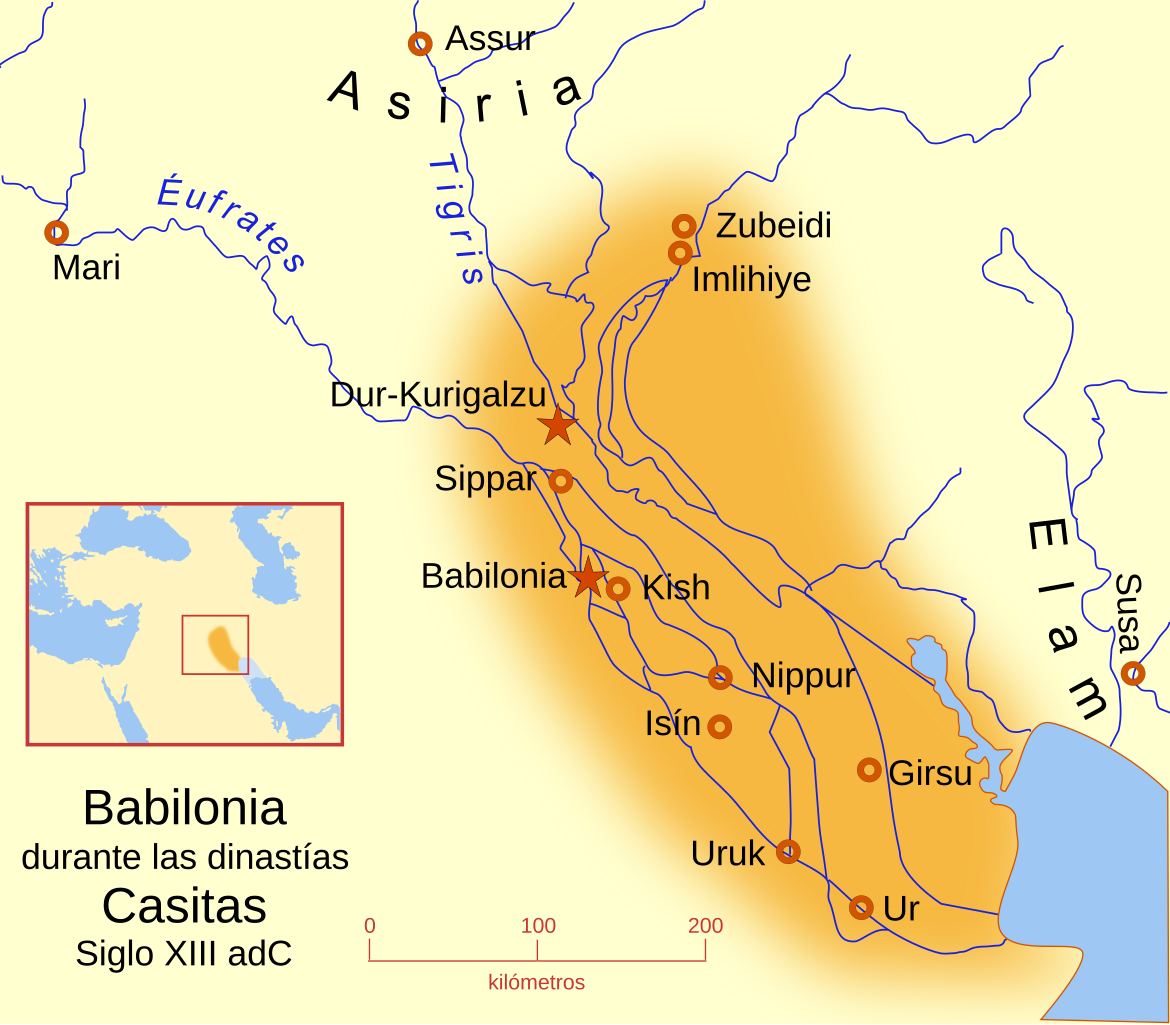
Español: Babilonia durante la dinastía Casita. Siglo XIII a. C. A map of the Babylonian Empire during the time of the Kassites, roughly the 13th century BC. This map shows the probable river courses and coastline at that time.
Tarix
Mənbə
Öz işi
Müəllif
MapMaster
Digər versiyalar
magyar
Other versions
English
Locator map
Español
Similar maps
Hammurabi's Babylonia Locator map
Hammurabi's Babylonia - English
Hammurabi's Babylonia - Català
References
Roaf, M. (1990) Cultural Atlas of Mesopotamia and the ancient Near East, Oxford: Facts on File. (In general, the basis for the ancient river courses and ancient coastline).
Lisenziya
I, the copyright holder of this work, hereby publish it under the following licenses:
Bu sənədi GNU Azad Sənədləşdirmə Lisenziyası, Versiya 1.2 və ya Azad Proqram Fondu tərəfindən nəşr olunan hər hansı sonrakı versiya şərtlərinə əsasən dəyişməz bölmələr, ön qapaq mətnləri və arxa qapaq mətnləri olmadan köçürmək, yayımlamaq və / və ya dəyişdirmək üçün icazə verilir; Lisenziyanın bir nüsxəsi GNU Azad Sənədləşdirmə Lisenziyası adlı hissəyə daxil edilmişdir.http://www.gnu.org/copyleft/fdl.htmlGFDLGNU Free Documentation Licensetruetrue
This file is licensed under the Creative Commons Attribution-Share Alike 4.0 International, 3.0 Unported, 2.5 Generic, 2.0 Generic and 1.0 Generic license.
Azadsınız:
paylaşmaq – əsəri köçürmək, paylamaq və ötürmək üçün
remiks etmək – əsəri adaptasiya etmək
Aşağıdakı şərtlərə riayət etməklə:
istinad – Müvafiq kredit verməlisiniz, lisenziyaya bir keçid verməlisiniz və dəyişikliklərin olub olmadığını bildirməlisiniz. Bunu hər hansı bir ağlabatan şəkildə edə bilərsiniz, ancaq lisenziyalaşdırıcının sizi və ya istifadənizi təsdiqləməsini təklif edən bir şəkildə deyil.
bənzər paylaşma – Əsəri remix edirsinizsə, dəyişdirirsinizsə və ya üzərində iş aparırsınızsa, öz töhfələrinizi orijinalda olduğu kimi eyni və ya uyğun lisenziya altında yayımlamalısınız.
{{Information |Description='''es''': Babilonia durante la dinastía Casitas Siglo XIII adC<br> A map of the Babylonian Empire during the time of the Kassites, roughly the 13th century BC. This map shows the probable river courses and co
fayl, babilonia, durante, dinastía, casitas, siglo, xiii, fayl, faylın, tarixçəsi, fayl, keçidləri, faylın, qlobal, istifadəsibu, faylın, formatındakı, görünüşünün, ölçüsü, piksel, digər, ölçülər, piksel, piksel, piksel, piksel, piksel, faylın, orijinalı, 8206. Fayl Faylin tarixcesi Fayl kecidleri Faylin qlobal istifadesiBu SVG faylin PNG formatindaki bu gorunusunun olcusu 658 576 piksel Diger olculer 274 240 piksel 548 480 piksel 877 768 piksel 1 170 1 024 piksel 2 340 2 048 piksel Faylin orijinali 8206 SVG fayli nominal olaraq 658 576 piksel faylin olcusu 173 KB Bu fayl Vikimedia Commons dadirve diger layihelerde istifade edile biler tesvir sehifesi Faylin tesvir sehifesine get Mundericat 1 Xulase 2 Other versions 3 Similar maps 4 References 5 Lisenziya Xulase IzahBabilonia durante la dinastia Casitas Siglo XIII adC ES svg Espanol Babilonia durante la dinastia Casita Siglo XIII nbsp a nbsp C A map of the Babylonian Empire during the time of the Kassites roughly the 13th century BC This map shows the probable river courses and coastline at that time Tarix 3 mart 2008 Menbe Oz isi Muellif MapMaster Diger versiyalar magyar Other versions English Locator map Espanol Similar maps Hammurabi s Babylonia Locator map Hammurabi s Babylonia English Hammurabi s Babylonia Catala References Roaf M 1990 Cultural Atlas of Mesopotamia and the ancient Near East Oxford Facts on File In general the basis for the ancient river courses and ancient coastline Lisenziya I the copyright holder of this work hereby publish it under the following licenses Bu senedi GNU Azad Senedlesdirme Lisenziyasi Versiya 1 2 ve ya Azad Proqram Fondu terefinden nesr olunan her hansi sonraki versiya sertlerine esasen deyismez bolmeler on qapaq metnleri ve arxa qapaq metnleri olmadan kocurmek yayimlamaq ve ve ya deyisdirmek ucun icaze verilir Lisenziyanin bir nusxesi GNU Azad Senedlesdirme Lisenziyasi adli hisseye daxil edilmisdir http www gnu org copyleft fdl html GFDL GNU Free Documentation License true trueThis file is licensed under the Creative Commons Attribution Share Alike 4 0 International 3 0 Unported 2 5 Generic 2 0 Generic and 1 0 Generic license Azadsiniz paylasmaq eseri kocurmek paylamaq ve oturmek ucun remiks etmek eseri adaptasiya etmek Asagidaki sertlere riayet etmekle istinad Muvafiq kredit vermelisiniz lisenziyaya bir kecid vermelisiniz ve deyisikliklerin olub olmadigini bildirmelisiniz Bunu her hansi bir aglabatan sekilde ede bilersiniz ancaq lisenziyalasdiricinin sizi ve ya istifadenizi tesdiqlemesini teklif eden bir sekilde deyil benzer paylasma Eseri remix edirsinizse deyisdirirsinizse ve ya uzerinde is aparirsinizsa oz tohfelerinizi orijinalda oldugu kimi eyni ve ya uygun lisenziya altinda yayimlamalisiniz https creativecommons org licenses by sa 4 0 CC BY SA 4 0 Creative Commons Attribution Share Alike 4 0 true trueIstediyiniz lisenziyani sece bilersiniz CaptionsazerbaycancaAdd a one line explanation of what this file representsItems portrayed in this filetesvir ediryaradicisome valueobyektin rolu fotoqrafWikimedia username nbsp ingilis MapMasterURL https commons wikimedia org wiki user MapMastermuellifin qisa adi MapMastercopyright status nbsp ingiliscopyrighted nbsp ingilislisenziyaCreative Commons Attribution ShareAlike 2 5 Generic nbsp ingilisCreative Commons Attribution ShareAlike 4 0 International nbsp ingilisCreative Commons Attribution ShareAlike 2 0 Generic nbsp ingilisGNU Free Documentation License version 1 2 or later nbsp ingilisCreative Commons Attribution ShareAlike 1 0 Generic nbsp ingilisCreative Commons Attribution ShareAlike 3 0 Unported nbsp ingilissource of file nbsp ingilisoriginal creation by uploader nbsp ingilisyaranma tarixi3 mart 2008MIME type nbsp ingilisimage svg xmlchecksum nbsp ingilis77e0eabfebebf0e2a567ed10b6a2f0875edfc432teyinetme usulu SHA 1 nbsp ingilisdata size nbsp ingilis177 545 Baythundurluyu boyu576 pikseleni658 piksel Faylin tarixcesi Faylin evvelki versiyasini gormek ucun gun tarix bolmesindeki tarixlere klikleyin Tarix VaxtKicik sekilOlculerIstifadeciSerh indiki20 46 17 yanvar 2009658 576 173 KB Phirosiberia Information Description Source Date Author Permission other versions 05 19 4 mart 2008661 580 177 KB MapMaster Information Description 039 039 039 es 039 039 039 Babilonia durante la dinastia Casitas Siglo XIII adC lt br gt A map of the Babylonian Empire during the time of the Kassites roughly the 13th century BC This map shows the probable river courses and co Fayl kecidleri Bu sekile olan kecidler Kis Sumer Faylin qlobal istifadesi Bu fayl asagidaki vikilerde istifade olunur arz wikipedia org layihesinde istifadesi كيش مدينه ضايعه فى بابل ca wikipedia org layihesinde istifadesi Kix Imperi paleobabilonic diq wikipedia org layihesinde istifadesi Kis Sumer en wikipedia org layihesinde istifadesi User Ryanmhorne pleiades List en wikivoyage org layihesinde istifadesi Ancient Mesopotamia Hillah eo wikipedia org layihesinde istifadesi Kiŝ es wikipedia org layihesinde istifadesi Babilonia reino Kish Isin Casitas Sippar Usuario MuchosMapas Renacimiento sumerio Kadashman Enlil II Piedra Michaux Imperio paleobabilonico Anexo Imperios por superficie Dinastia Casita Dur Kurigalzu eu wikipedia org layihesinde istifadesi Kish Kasita gl wikipedia org layihesinde istifadesi Isin Imperio Babilonico hy wikipedia org layihesinde istifadesi Աշխարհի պատմության խոշորագույն տերությունների կայսրությունների ցանկ Քիշ Շումեր ja wikipedia org layihesinde istifadesi 帝国の最大領域一覧 ku wikipedia org layihesinde istifadesi Kis ro wikipedia org layihesinde istifadesi Kiș Sumer ru wikipedia org layihesinde istifadesi Spisok krupnejshih gosudarstv v istorii uk wikipedia org layihesinde istifadesi Kish Shumer www wikidata org layihesinde istifadesi Q132272 Menbe https az wikipedia org wiki Fayl Babilonia durante la dinastia Casitas Siglo XIII adC ES svg, wikipedia, oxu, kitab, kitabxana, axtar, tap, hersey,
ne axtarsan burda
, en yaxsi meqale sayti, meqaleler, kitablar, oyrenmek, wiki, bilgi, tarix, seks, porno, indir, yukle, sex, azeri sex, azeri, seks yukle, sex yukle, izle, seks izle, porno izle, mobil seks, telefon ucun, chat, azeri chat, tanisliq, tanishliq, azeri tanishliq, sayt, medeni, medeni saytlar, chatlar, mekan, tanisliq mekani, mekanlari, yüklə, pulsuz, pulsuz yüklə, mp3, video, mp4, 3gp, jpg, jpeg, gif, png, şəkil, muisiqi, mahnı, kino, film, kitab, oyun, oyunlar.