Bu fayl "Vikimedia Commons"dadır və digər layihələrdə istifadə edilə bilər.
Faylın təsvir səhifəsinə get
Xülasə
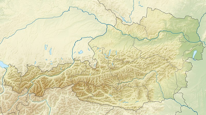
İzahAustria relief location map.jpg
English: Location map of Austria
Equirectangular projection, N/S stretching 150 %. Geographic limits of the map:
N: 49.2° N
S: 46.3° N
W: 9.4° E
E: 17.2° E
Made with Natural Earth. Free vector and raster map data @ naturalearthdata.com.
Tarix
Mənbə
Öz işi
Müəllif
Uwe Dedering
Digər versiyalar
Derivative works of this file: ÖRF 2011.png
Equivalent political map
Lisenziya
I, the copyright holder of this work, hereby publish it under the following licenses:
Bu fayl Creative Commons Attribution-Share Alike 3.0 Sinqapur lisenziyası altında yayımlanır.
Azadsınız:
paylaşmaq – əsəri köçürmək, paylamaq və ötürmək üçün
remiks etmək – əsəri adaptasiya etmək
Aşağıdakı şərtlərə riayət etməklə:
istinad – Müvafiq kredit verməlisiniz, lisenziyaya bir keçid verməlisiniz və dəyişikliklərin olub olmadığını bildirməlisiniz. Bunu hər hansı bir ağlabatan şəkildə edə bilərsiniz, ancaq lisenziyalaşdırıcının sizi və ya istifadənizi təsdiqləməsini təklif edən bir şəkildə deyil.
bənzər paylaşma – Əsəri remix edirsinizsə, dəyişdirirsinizsə və ya üzərində iş aparırsınızsa, öz töhfələrinizi orijinalda olduğu kimi eyni və ya uyğun lisenziya altında yayımlamalısınız.
Bu sənədi GNU Azad Sənədləşdirmə Lisenziyası, Versiya 1.2 və ya Azad Proqram Fondu tərəfindən nəşr olunan hər hansı sonrakı versiya şərtlərinə əsasən dəyişməz bölmələr, ön qapaq mətnləri və arxa qapaq mətnləri olmadan köçürmək, yayımlamaq və / və ya dəyişdirmək üçün icazə verilir; Lisenziyanın bir nüsxəsi GNU Azad Sənədləşdirmə Lisenziyası adlı hissəyə daxil edilmişdir.http://www.gnu.org/copyleft/fdl.htmlGFDLGNU Free Documentation Licensetruetrue
İstədiyiniz lisenziyanı seçə bilərsiniz.
This map image could be re-created using vector graphics as an SVG file. This has several advantages; see Commons:Media for cleanup for more information. If an SVG form of this image is available, please upload it and afterwards replace this template with {{vector version available|new image name}}. It is recommended to name the SVG file "Austria relief location map.svg" – then the template Vector version available (or Vva) does not need the new image name parameter.
This map image was uploaded in the JPEG format even though it consists of non-photographic data. This information could be stored more efficiently or accurately in the PNG or SVG format. If possible, please upload a PNG or SVG version of this image without compression artifacts, derived from a non-JPEG source (or with existing artifacts removed). After doing so, please tag the JPEG version with {{Superseded|NewImage.ext}} and remove this tag. This tag should not be applied to photographs or scans. For more information, see {{BadJPEG}}.
Captions
Add a one-line explanation of what this file represents
{{Information |Description={{en|1=Location map of Austria}} Equirectangular projection, N/S stretching 150 %. Geographic limits of the map: * N: 49.2° N * S: 46.3° N * W: 9.4° E * E: 17.2° E Made with Natural Earth. Free
fayl, austria, relief, location, fayl, faylın, tarixçəsi, fayl, keçidləri, faylın, qlobal, istifadəsisınaq, göstərişi, ölçüsü, piksel, digər, ölçülər, piksel, piksel, piksel, faylın, orijinalı, 8206, piksel, fayl, həcmi, mime, növü, image, jpeg, fayl, vikimedi. Fayl Faylin tarixcesi Fayl kecidleri Faylin qlobal istifadesiSinaq gosterisi olcusu 800 446 piksel Diger olculer 320 178 piksel 640 357 piksel 1 256 700 piksel Faylin orijinali 8206 1 256 700 piksel fayl hecmi 677 KB MIME novu image jpeg Bu fayl Vikimedia Commons dadirve diger layihelerde istifade edile biler Faylin tesvir sehifesine get Xulase IzahAustria relief location map jpg English Location map of Austria Equirectangular projection N S stretching 150 nbsp Geographic limits of the map N 49 2 N S 46 3 N W 9 4 E E 17 2 E Made with Natural Earth Free vector and raster map data naturalearthdata com Tarix 24 aprel 2010 Menbe Oz isi Muellif Uwe Dedering Diger versiyalar Derivative works of this file nbsp ORF 2011 png Equivalent political map Lisenziya I the copyright holder of this work hereby publish it under the following licenses Bu fayl Creative Commons Attribution Share Alike 3 0 Sinqapur lisenziyasi altinda yayimlanir Azadsiniz paylasmaq eseri kocurmek paylamaq ve oturmek ucun remiks etmek eseri adaptasiya etmek Asagidaki sertlere riayet etmekle istinad Muvafiq kredit vermelisiniz lisenziyaya bir kecid vermelisiniz ve deyisikliklerin olub olmadigini bildirmelisiniz Bunu her hansi bir aglabatan sekilde ede bilersiniz ancaq lisenziyalasdiricinin sizi ve ya istifadenizi tesdiqlemesini teklif eden bir sekilde deyil benzer paylasma Eseri remix edirsinizse deyisdirirsinizse ve ya uzerinde is aparirsinizsa oz tohfelerinizi orijinalda oldugu kimi eyni ve ya uygun lisenziya altinda yayimlamalisiniz https creativecommons org licenses by sa 3 0 CC BY SA 3 0 Creative Commons Attribution Share Alike 3 0 true true Bu senedi GNU Azad Senedlesdirme Lisenziyasi Versiya 1 2 ve ya Azad Proqram Fondu terefinden nesr olunan her hansi sonraki versiya sertlerine esasen deyismez bolmeler on qapaq metnleri ve arxa qapaq metnleri olmadan kocurmek yayimlamaq ve ve ya deyisdirmek ucun icaze verilir Lisenziyanin bir nusxesi GNU Azad Senedlesdirme Lisenziyasi adli hisseye daxil edilmisdir http www gnu org copyleft fdl html GFDL GNU Free Documentation License true trueIstediyiniz lisenziyani sece bilersiniz This map image could be re created using vector graphics as an SVG file This has several advantages see nbsp Commons Media for cleanup for more information If nbsp an nbsp SVG nbsp form nbsp of nbsp this nbsp image is available please upload it and afterwards replace this template with vector version available i new image name i It is recommended to name the SVG file Austria relief location map svg then the template Vector version available or Vva does not need the new image name parameter This map image was uploaded in the JPEG format even though it consists of non photographic data This information could be stored more efficiently or accurately in the PNG or SVG format If possible please upload a PNG or SVG version of this image without compression artifacts derived from a non JPEG source or with existing artifacts removed After doing so please tag the JPEG version with Superseded NewImage ext and remove this tag This tag should not be applied to photographs or scans For more information see BadJPEG CaptionsazerbaycancaAdd a one line explanation of what this file representsingilisLocation map of AustriaItems portrayed in this filetesvir edirAvstriyayaradiciSome value without a Vikiverilenler itemobyektin rolu fotoqrafmuellifin qisa adi Uwe DederingWikimedia username nbsp ingilis Uwe DederingURL nbsp ingilis http commons wikimedia org wiki User Uwe Dederingcopyright status nbsp ingiliscopyrighted nbsp ingilislisenziyaGNU Free Documentation License version 1 2 or later nbsp ingilisCreative Commons Attribution ShareAlike 3 0 Unported nbsp ingilisyaranma tarixi24 aprel 2010source of file nbsp ingilisoriginal creation by uploader nbsp ingilisMIME type nbsp ingilisimage jpeg Faylin tarixcesi Faylin evvelki versiyasini gormek ucun gun tarix bolmesindeki tarixlere klikleyin Tarix VaxtKicik sekilOlculerIstifadeciSerh indiki09 14 28 iyun 20101 256 700 677 KB Uwe Dederingvery little border change 12 24 26 aprel 20101 256 700 677 KB Uwe Dederingrhine 12 54 24 aprel 20101 256 700 676 KB Uwe Dedering Information Description en 1 Location map of Austria Equirectangular projection N S stretching 150 Geographic limits of the map N 49 2 N S 46 3 N W 9 4 E E 17 2 E Made with Natural Earth Free Fayl kecidleri Bu sekile olan kecidler Arlberq Hockeynig dagi Kalkalpen Milli Parki Koralpe Krimler selalesi Leoqanq daglari Lyolnbreyn su anbari Noyzidler golu Qrosvenediger Spannagel magarasi Tennen daglari Vaysenzee golu Venediger daglari Zabot su anbari Irott ko Sablon Yer xeritesi Avstriya Faylin qlobal istifadesi Bu fayl asagidaki vikilerde istifade olunur ab wikipedia org layihesinde istifadesi Amodul Location map data Austria Amodul Location map data Austria doc als wikipedia org layihesinde istifadesi Vorlage Positionskarte Osterreich Vorlage Positionskarte Osterreich Tirol am wikipedia org layihesinde istifadesi መለጠፊያ Location map ኦስትሪያ an wikipedia org layihesinde istifadesi Heutal ar wikipedia org layihesinde istifadesi قالب خريطة مواقع النمسا ليينز المركز الإسلامي في فيينا قائمة مدن وبلدات النمسا arz wikipedia org layihesinde istifadesi قالب Location map Austria قالب Location map Austria doc ast wikipedia org layihesinde istifadesi Modulu Minimapa data Austria Modulu Minimapa data Austria usu as wikipedia org layihesinde istifadesi স চ Location map Austria azb wikipedia org layihesinde istifadesi وین شابلون اوتریش خریطه سی ban wikipedia org layihesinde istifadesi Taman Nasional Gesause Taman Nasional Kalkalpen ba wikipedia org layihesinde istifadesi Ҡalyp PozKarta Avstriya be tarask wikipedia org layihesinde istifadesi Dyya be wikipedia org layihesinde istifadesi Grosglokner Shablon Na karce Aystryya Nojzidler Venski Les Cugshpice Ahenskae vozera Zamina Tantalava pyachora Vysoki Tayern Ens Milshteter Ze Gorny hrybet Arlberg bh wikipedia org layihesinde istifadesi Module Location map data Austria Module Location map data Austria doc bn wikipedia org layihesinde istifadesi ট মপ ল ট অবস থ ন ম নচ ত র Austria মড উল অবস থ ন ম নচ ত র উপ ত ত অস ট র য মড উল অবস থ ন ম নচ ত র উপ ত ত অস ট র য নথ bs wikipedia org layihesinde istifadesi Nacionalni park Gesause Sablon Lokacijska karta Austrija Spisak gradova u Austriji Grossglockner Leoganske planine Becka suma ca wikipedia org layihesinde istifadesi Llista de ciutats i viles d Austria Modul Location map data Austria Modul Location map data Austria us ceb wikipedia org layihesinde istifadesi Plantilya Location map Austria Weissensee lanaw sa Ostriya Karnten ce wikipedia org layihesinde istifadesi Kuckep Mettigan karta Avstri Bu faylin qlobal istifadesine baxin Menbe https az wikipedia org wiki Fayl Austria relief location map jpg, wikipedia, oxu, kitab, kitabxana, axtar, tap, hersey,
ne axtarsan burda
, en yaxsi meqale sayti, meqaleler, kitablar, oyrenmek, wiki, bilgi, tarix, seks, porno, indir, yukle, sex, azeri sex, azeri, seks yukle, sex yukle, izle, seks izle, porno izle, mobil seks, telefon ucun, chat, azeri chat, tanisliq, tanishliq, azeri tanishliq, sayt, medeni, medeni saytlar, chatlar, mekan, tanisliq mekani, mekanlari, yüklə, pulsuz, pulsuz yüklə, mp3, video, mp4, 3gp, jpg, jpeg, gif, png, şəkil, muisiqi, mahnı, kino, film, kitab, oyun, oyunlar.