Bu faylda fotoaparat və ya skanerlə əlavə olunmuş məlumatlar var. Əgər fayl sonradan redaktə olunubsa, bəzi parametrlər bu şəkildə göstərilənlərdən fərqli ola bilər.
_error
0
Dekabr 28, 2022
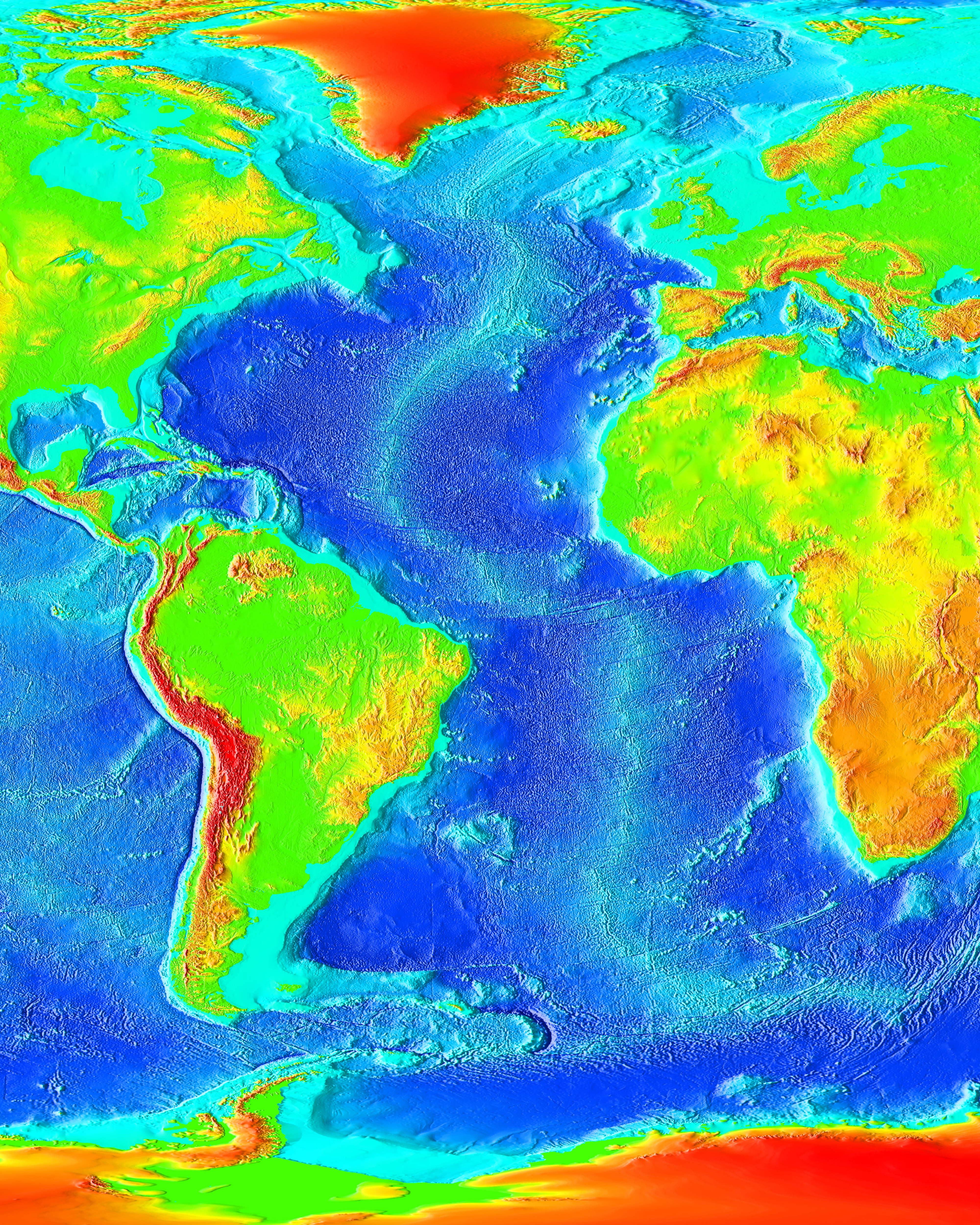
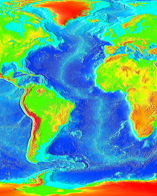
fayl, atlantic, bathymetry, fayl, faylın, tarixçəsi, istifadə, edilən, səhifələr, faylın, qlobal, istifadəsi, metaməlumatlarsınaq, göstərişi, ölçüsü, piksel, digər, ölçülər, piksel, piksel, piksel, piksel, piksel, faylın, orijinalı, 8206, piksel, fayl, həcmi, . Fayl Faylin tarixcesi Istifade edilen sehifeler Faylin qlobal istifadesi MetamelumatlarSinaq gosterisi olcusu 547 599 piksel Diger olculer 219 240 piksel 438 480 piksel 701 768 piksel 934 1 024 piksel 1 825 2 000 piksel Faylin orijinali 8206 1 825 2 000 piksel fayl hecmi 450 KB MIME novu image jpeg Bu fayl Vikimedia Commons dadirve diger layihelerde istifade edile biler Faylin tesvir sehifesine get IzahAtlantic bathymetry jpg English The Atlantic Ocean Menbe http www ngdc noaa gov mgg image 2minrelief htmlMuellif NOAA Public domain Public domain false falseThis image is in the public domain because it contains materials that originally came from the U S National Oceanic and Atmospheric Administration taken or made as part of an employee s official duties العربي ة cestina Deutsch Zazaki English espanol eesti suomi francais magyar italiano 日本語 한국어 makedonski മലയ ള Plattduutsch Nederlands polski portugues romană russkij sicilianu slovenscina Turkce tiếng Việt 中文 中文 简体 CaptionsazerbaycancaAdd a one line explanation of what this file representsingilisA bathymetric map of the Mid Atlantic RidgeItems portrayed in this filetesvir edirOrta Atlantika silsilesi Faylin tarixcesi Faylin evvelki versiyasini gormek ucun gun tarix bolmesindeki tarixlere klikleyin Tarix VaxtKicik sekilOlculerIstifadeciSerh indiki19 20 27 noyabr 20061 825 2 000 450 KB KorriganRetablissement de la version precedente 11 21 14 noyabr 2006547 599 97 KB Ludo29The Atlantic Ocean Source http www ngdc noaa gov mgg image 2minrelief html Recupere depuis Wikipedia en avec le meme nom 02 08 15 mart 20061 825 2 000 450 KB Interiot commonswikichange framing 02 03 15 mart 20061 491 2 000 372 KB Interiot commonswiki Summary The Atlantic Ocean Source http www ngdc noaa gov mgg image 2minrelief html Licensing PD USGov Category Ocean topography Istifade edilen sehifeler Bu sekile olan kecidler Atlantik okean Faylin qlobal istifadesi Bu fayl asagidaki vikilerde istifade olunur af wikipedia org layihesinde istifadesi Mid Atlantiese Rug ar wikipedia org layihesinde istifadesi المحيط الأطلسي ast wikipedia org layihesinde istifadesi Dosal mesoatlantica az wiktionary org layihesinde istifadesi Kateqoriya Atlantik okean Azerbaycan dili bat smg wikipedia org layihesinde istifadesi Atlanta ondenins ba wikipedia org layihesinde istifadesi Geografiya Atlantik okean beta wikiversity org layihesinde istifadesi ਵ ਦ ਅਕ ਮ ਡ ਆ ਜ ਗਰ ਕਤ ਅਭ ਆਨ ਭ ਗ ਲ ਐਟਲਸ POTD 1 be wikipedia org layihesinde istifadesi Atlantychny akiyan bn wikipedia org layihesinde istifadesi আটল ন ট ক মহ স গর মধ য আটল ন ট ক শ লশ র ca wikipedia org layihesinde istifadesi Ocea Atlantic co wikipedia org layihesinde istifadesi Oceanu Atlanticu crh wikipedia org layihesinde istifadesi Atlantik okean cy wikipedia org layihesinde istifadesi Cefnfor yr Iwerydd de wikipedia org layihesinde istifadesi Atlantischer Ozean Benutzer Daniel FR Insel Benutzer NatiSythen Karten de wikinews org layihesinde istifadesi Portal Ozeane de wiktionary org layihesinde istifadesi oceano Atlantico diq wikipedia org layihesinde istifadesi Okyanuso Atlantik en wikipedia org layihesinde istifadesi Atlantic Ocean Mid Atlantic Ridge Category Fish of the Atlantic Ocean List of fracture zones User XxThatPhatGuyxX sandbox Portal Oceans en wikibooks org layihesinde istifadesi High School Earth Science Seafloor Spreading en wikiversity org layihesinde istifadesi Educational Media Awareness Campaign Geography Atlases POTD 1 Educational Media Awareness Campaign Geography POTD Educational Media Awareness Campaign Geography Draft Location hypotheses of Atlantis Draft talk Location hypotheses of Atlantis Draft Keynote lectures Hydromorphology User RAYLEIGH22 sandbox User RAYLEIGH22 sandbox2 eo wikipedia org layihesinde istifadesi Atlantiko Oceanografio es wikipedia org layihesinde istifadesi Oceano Atlantico Dorsal mesoatlantica Categoria Peces del oceano Atlantico ext wikipedia org layihesinde istifadesi Oceanu Alanticu fi wikipedia org layihesinde istifadesi Atlantin valtameri fr wikipedia org layihesinde istifadesi Discussion Ocean Atlantique fr wikiversity org layihesinde istifadesi Volcanisme oceanique Presentation gd wikipedia org layihesinde istifadesi Cuan Siar gl wikipedia org layihesinde istifadesi Oceano Atlantico he wikipedia org layihesinde istifadesi פורטל גאולוגיה חדשות ארכיון 2011 חינוך גאוגרפי hi wikipedia org layihesinde istifadesi अटल ट क मह स गर Bu faylin qlobal istifadesine baxin Metamelumatlar Bu faylda fotoaparat ve ya skanerle elave olunmus melumatlar var Eger fayl sonradan redakte olunubsa bezi parametrler bu sekilde gosterilenlerden ferqli ola biler error0 Menbe https az wikipedia org wiki Fayl Atlantic bathymetry jpg, wikipedia, oxu, kitab, kitabxana, axtar, tap, hersey,
ne axtarsan burda
, en yaxsi meqale sayti, meqaleler, kitablar, oyrenmek, wiki, bilgi, tarix, seks, porno, indir, yukle, sex, azeri sex, azeri, seks yukle, sex yukle, izle, seks izle, porno izle, mobil seks, telefon ucun, chat, azeri chat, tanisliq, tanishliq, azeri tanishliq, sayt, medeni, medeni saytlar, chatlar, mekan, tanisliq mekani, mekanlari, yüklə, pulsuz, pulsuz yüklə, mp3, video, mp4, 3gp, jpg, jpeg, gif, png, şəkil, muisiqi, mahnı, kino, film, kitab, oyun, oyunlar.