Bu fayl "Vikimedia Commons"dadır və digər layihələrdə istifadə edilə bilər.
Faylın təsvir səhifəsinə get
This locator map image could be re-created using vector graphics as an SVG file. This has several advantages; see Commons:Media for cleanup for more information. If an SVG form of this image is available, please upload it and afterwards replace this template with {{vector version available|new image name}}. It is recommended to name the SVG file "Arnhem land locator.svg" – then the template Vector version available (or Vva) does not need the new image name parameter.
Xülasə
İzahArnhem land locator.png
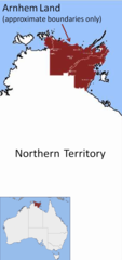
English: Location map showing approximate boundaries of Arnhem Land, Northern Territory, Australia
Tarix
Mənbə
Öz işi
Müəllif
Glen Dillon
Note: boundaries are approximate only. Also - Groote Eylandt and Goulburn Island are also part of Arnhem Land.
Lisenziya
Public domainPublic domainfalsefalse
Captions
Add a one-line explanation of what this file represents
{{Information |Description={{en|1=Location map showing approximate boundaries of Anrhem Land, Northern Territory, Australia}} |Source=Own work by uploader |Author=Glen Dillon |Date=9 September 2008 |Permission=see below |other_version
Fayl keçidləri
Bu faylı istifadə edən səhifə yoxdur.
Faylın qlobal istifadəsi
Bu fayl aşağıdakı vikilərdə istifadə olunur:
User:Glen Dillon
May 17, 2023
fayl, arnhem, land, locator, fayl, faylın, tarixçəsi, fayl, keçidləri, faylın, qlobal, istifadəsisınaq, göstərişi, ölçüsü, piksel, digər, ölçülər, piksel, piksel, faylın, orijinalı, 8206, piksel, fayl, həcmi, mime, növü, image, fayl, vikimedia, commons, dadırv. Fayl Faylin tarixcesi Fayl kecidleri Faylin qlobal istifadesiSinaq gosterisi olcusu 282 600 piksel Diger olculer 113 240 piksel 489 1 040 piksel Faylin orijinali 8206 489 1 040 piksel fayl hecmi 227 KB MIME novu image png Bu fayl Vikimedia Commons dadirve diger layihelerde istifade edile biler Faylin tesvir sehifesine get This locator map image could be re created using vector graphics as an SVG file This has several advantages see nbsp Commons Media for cleanup for more information If nbsp an nbsp SVG nbsp form nbsp of nbsp this nbsp image is available please upload it and afterwards replace this template with vector version available i new image name i It is recommended to name the SVG file Arnhem land locator svg then the template Vector version available or Vva does not need the new image name parameter Xulase IzahArnhem land locator png English Location map showing approximate boundaries of Arnhem Land Northern Territory Australia Tarix 9 sentyabr 2008 Menbe Oz isi Muellif Glen Dillon Note boundaries are approximate only Also Groote Eylandt and Goulburn Island are also part of Arnhem Land Lisenziya Public domain Public domain false false Men bu eserin muellif huquqlarinin sahibi kimi eseri ictimai mulkiyyete verirem Bu icaze butun dunyada quvvededir In some countries this may not be legally possible if so Bunun qanunla mumkun olmadigi hallarda Istenilen sexse istenilen meqsed ucun qanunlar terefinden qadagan edilmeyince hec bir sert qoymadan bu isden istifade haqqini bagislayiram CaptionsazerbaycancaAdd a one line explanation of what this file representsItems portrayed in this filetesvir ediryaradiciSome value without a Vikiverilenler itemmuellifin qisa adi Glen DillonWikimedia username nbsp ingilis Glen DillonURL nbsp ingilis http commons wikimedia org wiki User Glen Dilloncopyright status nbsp ingiliscopyrighted dedicated to the public domain by copyright holder nbsp ingilislisenziyareleased into the public domain by the copyright holder nbsp ingilisyaranma tarixi9 sentyabr 2008source of file nbsp ingilisoriginal creation by uploader nbsp ingilis Faylin tarixcesi Faylin evvelki versiyasini gormek ucun gun tarix bolmesindeki tarixlere klikleyin Tarix VaxtKicik sekilOlculerIstifadeciSerh indiki05 10 9 sentyabr 2008489 1 040 227 KB Glen Dillon Information Description en 1 Location map showing approximate boundaries of Anrhem Land Northern Territory Australia Source Own work by uploader Author Glen Dillon Date 9 September 2008 Permission see below other version Fayl kecidleri Bu fayli istifade eden sehife yoxdur Faylin qlobal istifadesi Bu fayl asagidaki vikilerde istifade olunur ar wikipedia org layihesinde istifadesi أرض أرنهيم en wikipedia org layihesinde istifadesi Arnhem Land User Glen Dillon et wikipedia org layihesinde istifadesi Arnhemi maa pfl wikipedia org layihesinde istifadesi Arnhemland pt wikipedia org layihesinde istifadesi Terra de Arnhem simple wikipedia org layihesinde istifadesi Arnhem Land Menbe https az wikipedia org wiki Fayl Arnhem land locator png, wikipedia, oxu, kitab, kitabxana, axtar, tap, hersey,
ne axtarsan burda
, en yaxsi meqale sayti, meqaleler, kitablar, oyrenmek, wiki, bilgi, tarix, seks, porno, indir, yukle, sex, azeri sex, azeri, seks yukle, sex yukle, izle, seks izle, porno izle, mobil seks, telefon ucun, chat, azeri chat, tanisliq, tanishliq, azeri tanishliq, sayt, medeni, medeni saytlar, chatlar, mekan, tanisliq mekani, mekanlari, yüklə, pulsuz, pulsuz yüklə, mp3, video, mp4, 3gp, jpg, jpeg, gif, png, şəkil, muisiqi, mahnı, kino, film, kitab, oyun, oyunlar.