Bu fayl "Vikimedia Commons"dadır və digər layihələrdə istifadə edilə bilər.
təsvir səhifəsi
Faylın təsvir səhifəsinə get
Xülasə
İzahAntarctica 6400px from Blue Marble.jpg
العربية: القارَّة القُطبيَّة الجنوبيَّة (أنتاركتيكا). صورة ساتليَّة تابعة لِوكالة ناسا، من ضمن بيانات الگُلَّة الزرقاء المُرسلة عبر الأقمار الاصطناعيَّة (من على بُعد كيلومترٍ واحد من العدسة الساتليَّة المُستخدمة). "تمَّ مزج بينات "MODIS" المُخصصة لِدراسة حالة الجليد القطبي مع تلك الخاصَّة بالإدارة القوميَّة لِدراسة المُحيطات والمُناخ—التي تمَّ الحصول عليها عبر الراديومتر الأكثر تطوُّرًا." تمَّ توليد الصورة باستخدام برنامج C مُخصص للتعامل مع صور وبيانات الگُلَّة الزرقاء، كما تمَّ الحصول على مُعادلات الإسقاط الشاقولي من موقع عالم الرِّياضيَّات. مُلاحظة: تمَّ تعديل هذه الصورة يدويًّا في سبيل ملء بعض المناطق ذات العُنصورات (الپكسلات) السوداء، في الرُبعيَّة العُليا اليُمنى. يُعتقد بأنَّ تلك العُنصورات السوداء ظهرت نتيجة فُقدان بعض البيانات الخاصَّة بغطاء الأرض \ البحر المُستعملة في صناعة صورة الگُلَّة الزرقاء الأصليَّة.
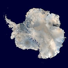
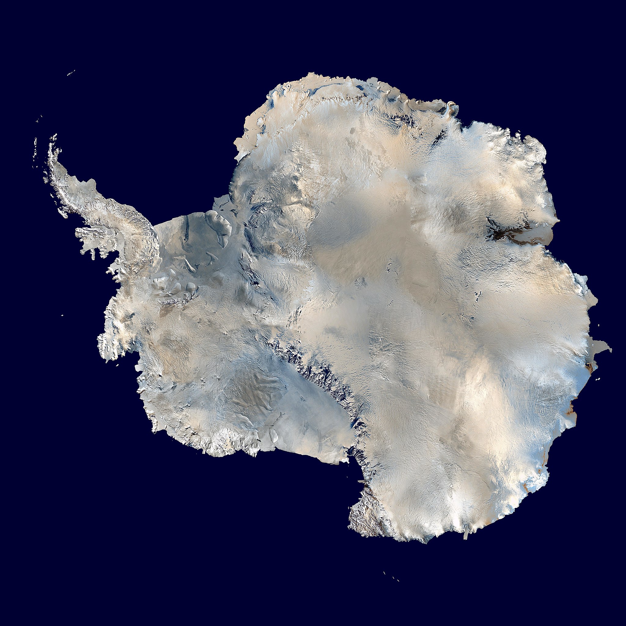
English: Antarctica. An orthographic projection of NASA's Blue Marble data set (1 km resolution global satellite composite). "MODIS observations of polar sea ice were combined with observations of Antarctica made by the National Oceanic and Atmospheric Administration’s AVHRR sensor—the Advanced Very High Resolution Radiometer." Image was generated using a custom C program for handling the Blue Marble files, with orthographic projection formulas from MathWorld. Note: this image has been manually modified to fill in an area of black pixels in the ocean, in the upper right quadrant. The black pixels are presumed to be due to missing data in the land/sea mask used in making the original Blue Marble image.
Español: El continente antártico. La imagen es una proyección ortogonal creada a partir del conjunto de datos satelitales Blue Marble de la NASA con una resolución de un kilómetro.
Français : Le continent Antarctique. L’image est construite en projection orthographique à partir des données satellites « Blue Marble » de la NASA, ayant une résolution d’un kilomètre. Les images de la banquise, prises par MODIS, ont été combinées avec celles du radiomètre avancé à très haute résolution de la National Oceanic and Atmospheric Administration pour former celle-ci. Elle a été générée en utilisant le logiciel MathWorld. Note : cette image a été modifiée manuellement pour remplir une zone de pixels noir dans l’océan, dans le coin en haut à droite. Ces pixels manquants sont supposés être dus à des données manquantes dans le masque terre-mer utilisé pour construire l'image original de Blue Marble.
Napulitano: Antartide, vista d’ ’o cielo.
Polski: Antarktyda. Odwzorowanie prostokątne opublikowanego w 2002 roku przez NASA zestawu danych Blue Marble.
مصرى: انتاركتيكا
فارسی: جنوبگان
Українська: Антарктида в ортографічній проекції з роздільною здатністю 1 км, на основі даних супутника MODIS.
Derivative works of this file: Antarctic Peninsula satellite image.jpgImage:Antarctica satellite globe.jpg
Assessment
This file was a finalist in Picture of the Year 2013. This file was the picture of the day on oktyabr 05, 2014. This is a featured picture on Wikimedia Commons (Featured pictures) and is considered one of the finest images.
Vikipediya
This is a featured picture on the ərəb language Wikipedia (صور مختارة) and is considered one of the finest images. This is a featured picture on the ingilis language Wikipedia (Featured pictures) and is considered one of the finest images. This is a featured picture on the fars language Wikipedia (نگارههای برگزیده) and is considered one of the finest images. This is a featured picture on the türk language Wikipedia (Seçkin resimler) and is considered one of the finest images.
If you have an image of similar quality that can be published under a suitable copyright license, be sure to upload it, tag it, and nominate it.
This image was selected as picture of the day on Wikimedia Commons for 5 October 2014. It was captioned as follows:
English: Antarctica. An orthographic projection of NASA's Blue Marble data set.
Other languages:
Bosanski: Antarktika. Ortografska projekcija NASA-inog Blue Marble podatkovnog seta.
Čeština: Antarktida v ortografické projekci ze souboru dat a fotografií NASA - NASA's Blue Marble data set.
English: Antarctica. An orthographic projection of NASA's Blue Marble data set.
Français : Le continent Antarctique, image construite en projection orthographique à partir des données satellites « Blue Marble » de la NASA.
Italiano: Proiezione ortogonale dell'Antartide della serie Blue Marble Next Generation della NASA, scattate con strumenti MODIS.
Magyar: A NASA MODIS (Moderate-resolution Imaging Spectroradiometer) műszerével készült műholdkép az Antarktisz földrajzi zónában elhelyezkedő Antarktika kontinensről
Nederlands: Een orthografische projectie van Antarctica uit de Blue Marble-serie.
Polski: Antarktyda. Odwzorowanie prostokątne opublikowanego w 2002 roku przez NASA zestawu danych Blue Marble.
Русский: Спутниковая фотография Антарктиды.
한국어: 남극 대륙. 미항공우주국 블루 마블 데이터 세트의 정사영.
中文: 南极洲正投影,来自NASA中分辨率成像光谱仪捕获的数据集。
Annotations
InfoField
This image is annotated: View the annotations at Commons
3147
3168
96
96
6400
6400
العربية: القُطب الجنوبي حوالي سنة 2014
English: South Pole as of about 2014
Captions
Add a one-line explanation of what this file represents
{{Information |Description=Antarctica. An orthographic projection of NASA's Blue Marble data set (1 km resolution global satellite composite). "MODIS observations of polar sea ice were combined with observations of Antarctica made by th
Bu faylda fotoaparat və ya skanerlə əlavə olunmuş məlumatlar var. Əgər fayl sonradan redaktə olunubsa, bəzi parametrlər bu şəkildə göstərilənlərdən fərqli ola bilər.
_error
0
İyul 11, 2023
fayl, antarctica, 6400px, from, blue, marble, fayl, faylın, tarixçəsi, fayl, keçidləri, faylın, qlobal, istifadəsi, metaməlumatlarsınaq, göstərişi, ölçüsü, piksel, digər, ölçülər, piksel, piksel, piksel, piksel, piksel, piksel, faylın, orijinalı, 8206, piksel,. Fayl Faylin tarixcesi Fayl kecidleri Faylin qlobal istifadesi MetamelumatlarSinaq gosterisi olcusu 600 600 piksel Diger olculer 240 240 piksel 480 480 piksel 768 768 piksel 1 024 1 024 piksel 2 048 2 048 piksel 6 400 6 400 piksel Faylin orijinali 8206 6 400 6 400 piksel fayl hecmi 3 31 MB MIME novu image jpeg Bu fayl Vikimedia Commons dadirve diger layihelerde istifade edile biler tesvir sehifesi Faylin tesvir sehifesine get Xulase IzahAntarctica 6400px from Blue Marble jpg العربية القار ة الق طبي ة الجنوبي ة أنتاركتيكا صورة ساتلي ة تابعة ل وكالة ناسا من ضمن بيانات الگ ل ة الزرقاء الم رسلة عبر الأقمار الاصطناعي ة من على ب عد كيلومتر واحد من العدسة الساتلي ة الم ستخدمة تم مزج بينات MODIS الم خصصة ل دراسة حالة الجليد القطبي مع تلك الخاص ة بالإدارة القومي ة ل دراسة الم حيطات والم ناخ التي تم الحصول عليها عبر الراديومتر الأكثر تطو ر ا تم توليد الصورة باستخدام برنامج C م خصص للتعامل مع صور وبيانات الگ ل ة الزرقاء كما تم الحصول على م عادلات الإسقاط الشاقولي من موقع عالم الر ياضي ات م لاحظة تم تعديل هذه الصورة يدوي ا في سبيل ملء بعض المناطق ذات الع نصورات الپكسلات السوداء في الر بعي ة الع ليا الي منى ي عتقد بأن تلك الع نصورات السوداء ظهرت نتيجة ف قدان بعض البيانات الخاص ة بغطاء الأرض البحر الم ستعملة في صناعة صورة الگ ل ة الزرقاء الأصلي ة English Antarctica An orthographic projection of NASA s Blue Marble data set 1 km resolution global satellite composite MODIS observations of polar sea ice were combined with observations of Antarctica made by the National Oceanic and Atmospheric Administration s AVHRR sensor the Advanced Very High Resolution Radiometer Image was generated using a custom C program for handling the Blue Marble files with orthographic projection formulas from MathWorld Note this image has been manually modified to fill in an area of black pixels in the ocean in the upper right quadrant The black pixels are presumed to be due to missing data in the land sea mask used in making the original Blue Marble image Espanol El continente antartico La imagen es una proyeccion ortogonal creada a partir del conjunto de datos satelitales Blue Marble de la NASA con una resolucion de un kilometro Francais nbsp Le continent Antarctique L image est construite en projection orthographique a partir des donnees satellites nbsp Blue Marble nbsp de la NASA ayant une resolution d un kilometre Les images de la banquise prises par MODIS ont ete combinees avec celles du radiometre avance a tres haute resolution de la National Oceanic and Atmospheric Administration pour former celle ci Elle a ete generee en utilisant le logiciel MathWorld Note nbsp cette image a ete modifiee manuellement pour remplir une zone de pixels noir dans l ocean dans le coin en haut a droite Ces pixels manquants sont supposes etre dus a des donnees manquantes dans le masque terre mer utilise pour construire l image original de Blue Marble Napulitano Antartide vista d o cielo Polski Antarktyda Odwzorowanie prostokatne opublikowanego w 2002 roku przez NASA zestawu danych Blue Marble مصرى انتاركتيكا فارسی جنوبگان Ukrayinska Antarktida v ortografichnij proekciyi z rozdilnoyu zdatnistyu 1 km na osnovi danih suputnika MODIS Tarix 5 oktyabr 2006 Menbe Own work using 2002 Blue Marble data http visibleearth nasa gov view rec php id 2433 Muellif Dave Pape Icaze Faylin tekrar istifadesi Public domain Public domain false false This work has been released into the public domain by its author Davepape This applies worldwide In some countries this may not be legally possible if so Davepape grants anyone the right to use this work for any purpose without any conditions unless such conditions are required by law Diger versiyalar Derivative works of this file nbsp Antarctic Peninsula satellite image jpgImage Antarctica satellite globe jpg Assessment This file was a finalist in Picture of the Year 2013 This file was the picture of the day on oktyabr 05 2014 This is a featured picture on Wikimedia Commons Featured pictures and is considered one of the finest images Vikipediya nbsp This is a featured picture on the ereb language Wikipedia صور مختارة and is considered one of the finest images nbsp This is a featured picture on the ingilis language Wikipedia Featured pictures and is considered one of the finest images nbsp This is a featured picture on the fars language Wikipedia نگاره های برگزیده and is considered one of the finest images nbsp This is a featured picture on the turk language Wikipedia Seckin resimler and is considered one of the finest images If you have an image of similar quality that can be published under a suitable copyright license be sure to upload it tag it and nominate it This image was selected as picture of the day on Wikimedia Commons for 5 October 2014 It was captioned as follows English Antarctica An orthographic projection of NASA s Blue Marble data set Other languages Bosanski Antarktika Ortografska projekcija NASA inog Blue Marble podatkovnog seta Cestina Antarktida v ortograficke projekci ze souboru dat a fotografii NASA NASA s Blue Marble data set English Antarctica An orthographic projection of NASA s Blue Marble data set Francais Le continent Antarctique image construite en projection orthographique a partir des donnees satellites nbsp Blue Marble nbsp de la NASA Italiano Proiezione ortogonale dell Antartide della serie Blue Marble Next Generation della NASA scattate con strumenti MODIS Magyar A NASA MODIS Moderate resolution Imaging Spectroradiometer muszerevel keszult muholdkep az Antarktisz foldrajzi zonaban elhelyezkedo Antarktika kontinensrolNederlands Een orthografische projectie van Antarctica uit de Blue Marble serie Polski Antarktyda Odwzorowanie prostokatne opublikowanego w 2002 roku przez NASA zestawu danych Blue Marble Russkij Sputnikovaya fotografiya Antarktidy 한국어 남극 대륙 미항공우주국 블루 마블 데이터 세트의 정사영 中文 南极洲正投影 来自NASA中分辨率成像光谱仪捕获的数据集 AnnotationsInfoFieldThis image is annotated View the annotations at Commons3147 3168 96 96 6400 6400 العربية الق طب الجنوبي حوالي سنة 2014 English South Pole as of about 2014CaptionsazerbaycancaAdd a one line explanation of what this file representsingilisThe continent of Antarctica circa 2006 almanDer arktische Kontinent ca 2006indoneziyaAntartikafransizRegion antarctiqueturkAntartika Kitasi 2006 civarlariItems portrayed in this filetesvir edirAntarktidayaradicisome valuemuellifin qisa adi Dave PapeURL https commons wikimedia org wiki user Davepapeobyektin rolu fotoqrafWikimedia username nbsp ingilis Davepapecopyright status nbsp ingiliscopyrighted dedicated to the public domain by copyright holder nbsp ingilislisenziyareleased into the public domain by the copyright holder nbsp ingilisCommons quality assessment nbsp ingilisWikimedia Commons featured picture nbsp ingilisyaranma tarixi5 oktyabr 2006MIME type nbsp ingilisimage jpeg Faylin tarixcesi Faylin evvelki versiyasini gormek ucun gun tarix bolmesindeki tarixlere klikleyin Tarix VaxtKicik sekilOlculerIstifadeciSerh indiki14 21 5 oktyabr 20066 400 6 400 3 31 MB Davepapetouched up part with missing data 07 49 5 oktyabr 20066 400 6 400 3 31 MB Davepape Information Description Antarctica An orthographic projection of NASA 039 s Blue Marble data set 1 km resolution global satellite composite MODIS observations of polar sea ice were combined with observations of Antarctica made by th Fayl kecidleri Bu sekile olan kecidler Buzlaq ortuyu Sehralarin dunyada sahesine gore siralamasi Portal Cografiya Faylin qlobal istifadesi Bu fayl asagidaki vikilerde istifade olunur ace wikipedia org layihesinde istifadesi Antartika Templat Gamba Peunileh 1 Kategori Antartika ady wikipedia org layihesinde istifadesi Antarktike af wikipedia org layihesinde istifadesi Wikipedia Uitgesoekte herdenkings Januarie Wikipedia Uitgesoekte herdenkings 30 Januarie Antarktika Yskap Wikipedia Beeld van die week 2014 Wikipedia Voorbladbeeld week 41 2014 Antarktiese Verdrag als wikipedia org layihesinde istifadesi Antarktis ang wikipedia org layihesinde istifadesi Wikipǣdia Gecorene gemynddagas 30 AEfterra Geola Wikipǣdia Gecorene gemynddagas AEfterra Geola Antarctica Flocc Antarctica anp wikipedia org layihesinde istifadesi अ ट र कट क ar wikipedia org layihesinde istifadesi القارة القطبية الجنوبية قائمة الصحاري حسب المساحة مستخدم Almountasir بوابة القارة القطبية الجنوبية مشاريع ويكي مستخدم لينيوس العربي مستخدم عمرو ميسرة مستخدم Ahmad jbr مستخدم عمرو كاملة ويكيبيديا ترشيحات الصور المختارة صورة بالقمر الصناعي للقارة القطبية الجنوبية مستخدم ديفيد صور ساهمت في جعلها مختارة مستخدم محمد نصار 1 مستخدم الحسن55 ويكيبيديا صور مختارة الفضاء والكون نظرة إلى الخلف ويكيبيديا صورة اليوم المختارة أكتوبر 2015 قالب صورة اليوم المختارة 2015 10 08 صفيحة القارة القطبية الجنوبية الجليدية ويكيبيديا صورة اليوم المختارة يناير 2017 قالب صورة اليوم المختارة 2017 01 01 مستخدم صندوق مستخدم مستخدم مشروع ويكي أنتاركتيكا ويكيبيديا صورة اليوم المختارة أكتوبر 2018 قالب صورة اليوم المختارة 2018 10 31 ويكيبيديا صورة اليوم المختارة أبريل 2020 قالب صورة اليوم المختارة 2020 04 22 ويكيبيديا صورة اليوم المختارة مارس 2023 قالب صورة اليوم المختارة 2023 03 03 برنامج نيوزيلندا لأبحاث القطب الجنوبي arz wikipedia org layihesinde istifadesi انتاركتيكا بحر سوموف بحر ماوسن ast wikipedia org layihesinde istifadesi L Antartida Neon Genesis Evangelion as wikipedia org layihesinde istifadesi এণ ট ৰ কট ক ক ম ৰ Bu faylin qlobal istifadesine baxin Metamelumatlar Bu faylda fotoaparat ve ya skanerle elave olunmus melumatlar var Eger fayl sonradan redakte olunubsa bezi parametrler bu sekilde gosterilenlerden ferqli ola biler error0 Menbe https az wikipedia org wiki Fayl Antarctica 6400px from Blue Marble jpg, wikipedia, oxu, kitab, kitabxana, axtar, tap, hersey,
ne axtarsan burda
, en yaxsi meqale sayti, meqaleler, kitablar, oyrenmek, wiki, bilgi, tarix, seks, porno, indir, yukle, sex, azeri sex, azeri, seks yukle, sex yukle, izle, seks izle, porno izle, mobil seks, telefon ucun, chat, azeri chat, tanisliq, tanishliq, azeri tanishliq, sayt, medeni, medeni saytlar, chatlar, mekan, tanisliq mekani, mekanlari, yüklə, pulsuz, pulsuz yüklə, mp3, video, mp4, 3gp, jpg, jpeg, gif, png, şəkil, muisiqi, mahnı, kino, film, kitab, oyun, oyunlar.