Bu fayl "Vikimedia Commons"dadır və digər layihələrdə istifadə edilə bilər.
Faylın təsvir səhifəsinə get
This map image could be re-created using vector graphics as an SVG file. This has several advantages; see Commons:Media for cleanup for more information. If an SVG form of this image is available, please upload it and afterwards replace this template with {{vector version available|new image name}}. It is recommended to name the SVG file "Africa relief location map.svg" – then the template Vector version available (or Vva) does not need the new image name parameter.
This map image was uploaded in the JPEG format even though it consists of non-photographic data. This information could be stored more efficiently or accurately in the PNG or SVG format. If possible, please upload a PNG or SVG version of this image without compression artifacts, derived from a non-JPEG source (or with existing artifacts removed). After doing so, please tag the JPEG version with {{Superseded|NewImage.ext}} and remove this tag. This tag should not be applied to photographs or scans. For more information, see {{BadJPEG}}.
Xülasə
İzahAfrica relief location map.jpg
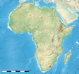
English: Blank physical map of political Africa, for geo-location purposes. Borders as in July 2011.
Français : Carte physique vierge de l'Afrique politique, destinée à la géolocalisation. Frontières telles qu'en juillet 2011.
Lambert azimutal equal-area projection, WGS84 datum
Standard meridian: 15°E
Standard parallel: 0°
Scale: 1:23,420,000 (precision: 5,855 km)
Tarix
Mənbə
Based upon File:Africa_map_blank.svg created by myself Sources of data:
VMap-0
Sudan/South Sudan 2011-07 border: Map Library (data of 2011-07-09)
NGDC World Data Bank II
CleanTOPO2
SRTM30 Plus
Müəllif
Eric Gaba (Sting - fr:Sting)
İcazə (Faylın təkrar istifadəsi)
Attribution and Share-Alike required
Any use of this map can be made as long as you credit me (Eric Gaba – Wikimedia Commons user: Sting) as the author and distribute the copies and derivative works under the same license(s) that the one(s) stated below. A message with a reply address would also be greatly appreciated.
Digər versiyalar
Same map but without international boundaries
Equivalent land cover map
Equivalent administrative map
Equivalent administrative map without rivers
Camera location
0° 00′ 00″ N, 15° 00′ 00″ E
View this and other nearby images on: OpenStreetMap
0.000000; 15.000000
Bu xəritə Qrafik emalatxanada (fr) yaradılmışdır. Siz həmçinin təsvirin yaxşılaşması ilə bağlı müraciət edə bilərsiniz.
Lisenziya
Eric Gaba, Wikimedia Commons user Sting, the copyright holder of this work, hereby publishes it under the following licenses:
Bu sənədi GNU Azad Sənədləşdirmə Lisenziyası, Versiya 1.2 və ya Azad Proqram Fondu tərəfindən nəşr olunan hər hansı sonrakı versiya şərtlərinə əsasən dəyişməz bölmələr, ön qapaq mətnləri və arxa qapaq mətnləri olmadan köçürmək, yayımlamaq və / və ya dəyişdirmək üçün icazə verilir; Lisenziyanın bir nüsxəsi GNU Azad Sənədləşdirmə Lisenziyası adlı hissəyə daxil edilmişdir.http://www.gnu.org/copyleft/fdl.htmlGFDLGNU Free Documentation Licensetruetrue
Bu fayl Creative Commons Attribution-Share Alike 3.0 Sinqapur lisenziyası altında yayımlanır.
İstinad: Eric Gaba, Wikimedia Commons user Sting
Azadsınız:
paylaşmaq – əsəri köçürmək, paylamaq və ötürmək üçün
remiks etmək – əsəri adaptasiya etmək
Aşağıdakı şərtlərə riayət etməklə:
istinad – Müvafiq kredit verməlisiniz, lisenziyaya bir keçid verməlisiniz və dəyişikliklərin olub olmadığını bildirməlisiniz. Bunu hər hansı bir ağlabatan şəkildə edə bilərsiniz, ancaq lisenziyalaşdırıcının sizi və ya istifadənizi təsdiqləməsini təklif edən bir şəkildə deyil.
bənzər paylaşma – Əsəri remix edirsinizsə, dəyişdirirsinizsə və ya üzərində iş aparırsınızsa, öz töhfələrinizi orijinalda olduğu kimi eyni və ya uyğun lisenziya altında yayımlamalısınız.
Bu faylda fotoaparat və ya skanerlə əlavə olunmuş məlumatlar var. Əgər fayl sonradan redaktə olunubsa, bəzi parametrlər bu şəkildə göstərilənlərdən fərqli ola bilər.
Orientasiya
Normal
Üfüqi xətt
89,9922 dpi
Şaquli xətt
89,9922 dpi
Proqram təminatı
Adobe Photoshop CS5 Windows
Faylın dəyişməsi tarixi və vaxtı
15:33, 14 iyul 2011
Rəng sahəsi
sRGB
Tarix və vaxt rəqəmləşdirilir
11:02, 14 iyul 2011
Date metadata was last modified
12:33, 14 iyul 2011
Unique ID of original document
xmp.did:9E8CD3E746AEE011BF06D6CCD47BECCC
Yanvar 08, 2023
fayl, africa, relief, location, fayl, faylın, tarixçəsi, istifadə, edilən, səhifələr, faylın, qlobal, istifadəsi, metaməlumatlarsınaq, göstərişi, ölçüsü, piksel, digər, ölçülər, piksel, piksel, piksel, piksel, piksel, faylın, orijinalı, 8206, piksel, fayl, həc. Fayl Faylin tarixcesi Istifade edilen sehifeler Faylin qlobal istifadesi MetamelumatlarSinaq gosterisi olcusu 635 600 piksel Diger olculer 254 240 piksel 508 480 piksel 813 768 piksel 1 084 1 024 piksel 1 525 1 440 piksel Faylin orijinali 8206 1 525 1 440 piksel fayl hecmi 522 KB MIME novu image jpeg Bu fayl Vikimedia Commons dadirve diger layihelerde istifade edile biler Faylin tesvir sehifesine get This map image could be re created using vector graphics as an SVG file This has several advantages see Commons Media for cleanup for more information If an SVG form of this image is available please upload it and afterwards replace this template with vector version available i new image name i It is recommended to name the SVG file Africa relief location map svg then the template Vector version available or Vva does not need the new image name parameter This map image was uploaded in the JPEG format even though it consists of non photographic data This information could be stored more efficiently or accurately in the PNG or SVG format If possible please upload a PNG or SVG version of this image without compression artifacts derived from a non JPEG source or with existing artifacts removed After doing so please tag the JPEG version with Superseded NewImage ext and remove this tag This tag should not be applied to photographs or scans For more information see BadJPEG Xulase IzahAfrica relief location map jpg English Blank physical map of political Africa for geo location purposes Borders as in July 2011 Francais Carte physique vierge de l Afrique politique destinee a la geolocalisation Frontieres telles qu en juillet 2011 Lambert azimutal equal area projection WGS84 datum Standard meridian 15 E Standard parallel 0 Scale 1 23 420 000 precision 5 855 km Tarix iyul 2010Menbe Based upon File Africa map blank svg created by myself Sources of data VMap 0 Sudan South Sudan 2011 07 border Map Library data of 2011 07 09 NGDC World Data Bank II CleanTOPO2 SRTM30 PlusMuellif Eric Gaba Sting fr Sting Icaze Faylin tekrar istifadesi Attribution and Share Alike requiredAny use of this map can be made as long as you credit me Eric Gaba Wikimedia Commons user Sting as the author and distribute the copies and derivative works under the same license s that the one s stated below A message with a reply address would also be greatly appreciated Diger versiyalar Same map but without international boundaries Equivalent land cover map Equivalent administrative map Equivalent administrative map without rivers Camera location0 00 00 N 15 00 00 E View this and other nearby images on OpenStreetMap0 000000 15 000000Bu xerite Qrafik emalatxanada fr yaradilmisdir Siz hemcinin tesvirin yaxsilasmasi ile bagli muraciet ede bilersiniz Lisenziya Eric Gaba Wikimedia Commons user Sting the copyright holder of this work hereby publishes it under the following licenses Bu senedi GNU Azad Senedlesdirme Lisenziyasi Versiya 1 2 ve ya Azad Proqram Fondu terefinden nesr olunan her hansi sonraki versiya sertlerine esasen deyismez bolmeler on qapaq metnleri ve arxa qapaq metnleri olmadan kocurmek yayimlamaq ve ve ya deyisdirmek ucun icaze verilir Lisenziyanin bir nusxesi GNU Azad Senedlesdirme Lisenziyasi adli hisseye daxil edilmisdir http www gnu org copyleft fdl html GFDL GNU Free Documentation License true trueBu fayl Creative Commons Attribution Share Alike 3 0 Sinqapur lisenziyasi altinda yayimlanir Istinad Eric Gaba Wikimedia Commons user StingAzadsiniz paylasmaq eseri kocurmek paylamaq ve oturmek ucun remiks etmek eseri adaptasiya etmek Asagidaki sertlere riayet etmekle istinad Muvafiq kredit vermelisiniz lisenziyaya bir kecid vermelisiniz ve deyisikliklerin olub olmadigini bildirmelisiniz Bunu her hansi bir aglabatan sekilde ede bilersiniz ancaq lisenziyalasdiricinin sizi ve ya istifadenizi tesdiqlemesini teklif eden bir sekilde deyil benzer paylasma Eseri remix edirsinizse deyisdirirsinizse ve ya uzerinde is aparirsinizsa oz tohfelerinizi orijinalda oldugu kimi eyni ve ya uygun lisenziya altinda yayimlamalisiniz https creativecommons org licenses by sa 3 0 CC BY SA 3 0 Creative Commons Attribution Share Alike 3 0 true trueIstediyiniz lisenziyani sece bilersiniz CaptionsazerbaycancaAdd a one line explanation of what this file representsfransizCarte physique vierge de d AfriquealmanPhysische Karte AfrikasItems portrayed in this filetesvir edirAfrikacopyright status ingiliscopyrighted ingilislisenziyaCreative Commons Attribution ShareAlike 3 0 Unported ingilisGNU Free Documentation License version 1 2 or later ingilisyaranma tarixiiyul 2010coordinates of the point of view ingilis0 0 0 000 N 15 0 0 000 EMIME type ingilisimage jpeg Faylin tarixcesi Faylin evvelki versiyasini gormek ucun gun tarix bolmesindeki tarixlere klikleyin en yeni en evvelki Goster 10 daha yeni 10 daha kohne 10 20 50 100 250 500 Tarix VaxtKicik sekilOlculerIstifadeciSerh indiki12 27 18 iyul 20221 525 1 440 522 KB M BittonReverted to version as of 21 54 5 May 2022 UTC per COM OVERWRITE 11 29 18 iyul 20221 627 1 536 472 KB Jacob300Reverted to version as of 15 02 5 May 2022 UTC 21 54 5 may 20221 525 1 440 522 KB M BittonReverted to version as of 19 03 14 July 2011 UTC per COM OVERWRITE 15 02 5 may 20221 627 1 536 472 KB Jacob300Reverted to version as of 17 16 9 January 2022 UTC 18 23 9 yanvar 20221 525 1 440 522 KB M BittonReverted to version as of 19 03 14 July 2011 UTC per COM OVERWRITE 17 16 9 yanvar 20221 627 1 536 472 KB Jacob300Reverted to version as of 01 08 19 October 2021 UTC 23 16 19 oktyabr 20211 525 1 440 522 KB M BittonReverted to version as of 19 03 14 July 2011 UTC per COM OVERWRITE 01 08 19 oktyabr 20211 627 1 536 472 KB GebageboAdded dotted line to indicate Somaliland 19 03 14 iyul 20111 525 1 440 522 KB StingSudan South Sudan 07 2011 border update 13 31 19 iyul 20101 525 1 440 424 KB StingColor profile en yeni en evvelki Goster 10 daha yeni 10 daha kohne 10 20 50 100 250 500 Istifade edilen sehifeler Bu sekile olan kecidler Almadi burnu Blanko burnu Boyuk Sehra Cozil bogazi Keyp Kross yarimadasi Keyp Poynt burnu Konqo cokekliyi Liviya sehrasi Lopes burnu Mozambik bogazi Qran Kanariya Samburu tebiet qorugu Sanqa mesesi Serengeti Tenere Umid burnu Ierro Iqidi sehra Iyne burnu Sablon Sehra Sablon Sehra doc Sablon Yer xeritesi Afrika Faylin qlobal istifadesi Bu fayl asagidaki vikilerde istifade olunur als wikipedia org layihesinde istifadesi Victoriasee Tanganjikasee Vorlage Positionskarte Afrika Malawisee Vorlage Positionskarte Reunion Vorlage Positionskarte Mayotte ar wikipedia org layihesinde istifadesi جبال تيبستي قالب خريطة مواقع أفريقيا وحدة Location map data Africa وحدة Location map data Africa شرح معبر بنقردان رأس جدير زرافات دابوس غابات الكونغو المطيرة ast wikipedia org layihesinde istifadesi Modulu Minimapa data Africa usu Modulu Minimapa data Africa av wikipedia org layihesinde istifadesi Afrika Nil Shablon BakIKarta Afrika Halip BakӀKarta Afrika Kilimandzharo megӀer azb wikipedia org layihesinde istifadesi قاهیره مانروویا داکار بیسائو کینشاسا آنتاناناریوو آکرا موشی شهر تانقا تانزانیا عنابه لوساکا اقصر کاکامقا کنیا الجزیره موروقورو هرجیسا نیامی تونس شهر وهران الجزاییر العیون آبوجا کامپالا یائونده دارالسلام تانزانیا رباط مراکش لوآندا انجامنا موقادیشو لیبرویل دودوما Bu faylin qlobal istifadesine baxin Metamelumatlar Bu faylda fotoaparat ve ya skanerle elave olunmus melumatlar var Eger fayl sonradan redakte olunubsa bezi parametrler bu sekilde gosterilenlerden ferqli ola biler OrientasiyaNormalUfuqi xett89 9922 dpiSaquli xett89 9922 dpiProqram teminatiAdobe Photoshop CS5 WindowsFaylin deyismesi tarixi ve vaxti15 33 14 iyul 2011Reng sahesisRGBTarix ve vaxt reqemlesdirilir11 02 14 iyul 2011Date metadata was last modified12 33 14 iyul 2011Unique ID of original documentxmp did 9E8CD3E746AEE011BF06D6CCD47BECCC Menbe https az wikipedia org wiki Fayl Africa relief location map jpg, wikipedia, oxu, kitab, kitabxana, axtar, tap, hersey,
ne axtarsan burda
, en yaxsi meqale sayti, meqaleler, kitablar, oyrenmek, wiki, bilgi, tarix, seks, porno, indir, yukle, sex, azeri sex, azeri, seks yukle, sex yukle, izle, seks izle, porno izle, mobil seks, telefon ucun, chat, azeri chat, tanisliq, tanishliq, azeri tanishliq, sayt, medeni, medeni saytlar, chatlar, mekan, tanisliq mekani, mekanlari, yüklə, pulsuz, pulsuz yüklə, mp3, video, mp4, 3gp, jpg, jpeg, gif, png, şəkil, muisiqi, mahnı, kino, film, kitab, oyun, oyunlar.