Bu fayl "Vikimedia Commons"dadır və digər layihələrdə istifadə edilə bilər.
Faylın təsvir səhifəsinə get
Artist
Matthaus Seutter (1678–1757)
Alternativ adlar
Matthäus Seutter der Ältere; Matthias Seutter
İzah
German cartographer, engraver və publisher
Doğum/ölüm tarixi
20 sentyabr 1678
mart 1757
Doğum/ölüm yeri
Auqsburq
Auqsburq
Yaradıcılıq məkanı
Auqsburq
Normativ yoxlama
: Q1364039
VIAF: 19982225
ISNI: 0000 0001 2277 2413
Open Library: OL5762443A
LCCN: n83052694
GND: 118613537
WorldCat
artist QS:P170,Q1364039
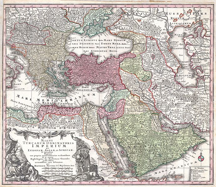
Başlıq
MAGNI TURCARUM DOMINATORIS IMPERIUM per EUROPAM, ASIAM ET AFRICAM, se extendens Regiones tam proprias, quan tributarias et clientelares ut et omnes Beglerbegatus sive Praefecturas Generales oculis sistens accuratissima cura delineatum per MATTHAEUM SEUTTER, S.C. Maj. Geogr. Aug.
İzah
English: A spectacular c. 1730 map of the Ottoman Empire, including Greece, Turkey, Persia, Egypt and Arabia, by the important Augsburg map publisher Gerog Matthaus Seutter. Depicts from Italy eastward to the Caspian Sea, which is depicted in its entirety. Includes Crimea and the Caucuses: Georgia, Circassia and Armenia. Extends south to include all of Arabia and the northern tip of the Horn of Africa. Generally accurate with a few cartographic anomalies. The Dead Sea is over-large and misshapen. A large and nonexistent lake appears just west of the Nile Delta. In the lower left hand quadrant there is a large decorative title cartouche attributed to the Augsburg silversmith Abraham Drentwet. Depicts the ottoman Emperor gloriously robed with and enthroned. On the ground before him two men bow and offer hum treasures. The images on the right of the title offer a more allegorical references and include an European holding a globe, a lion, the Rod of Asclepius, a Medusa head shield and s spear. Angels with trumpets look on from above. A map key appears in the lower right quadrant. Cartographically similar to Visscher's 1690 map of the same area. This is a rather unusual state of the map and one of the few examples wherein S.G. Maj Geogr. Aug follows Seutter's name in the title cartouche. The only comparable example we have found is in the British Museum.
Tarix
circa 1730
date QS:P571,+1730-00-00T00:00:00Z/9,P1480,Q5727902
This file was provided to Wikimedia Commons by Geographicus Rare Antique Maps, a specialist dealer in rare maps and other cartography of the 15th, 16th, 17th, 18th and 19th centuries, as part of a cooperation project.
العربيَّة | Deutsch | English | suomi | français | македонски | Nederlands | polski | +/−
İcazə (Faylın təkrar istifadəsi)
Bu şəkil, təsviri incəsənət əsərinin orijinal ikiölçülü dəqiq fotoqrafiya reproduksiyasıdır. Təsviri incəsənətin bu əsəri öz-özlüyündə aşağıdakı səbəblərdən ictimai varidat sayılır:
Public domainPublic domainfalsefalse
https://creativecommons.org/publicdomain/mark/1.0/PDMCreative Commons Public Domain Mark 1.0falsefalse
"Vikimedia Fondu" tutduğu rəsmi mövqe ondan ibarətdir ki, "ictimai varidat olan təsviri incəsənət əsərlərinin ikiölçülü dəqiq reproduksiyaları da ictimai varidat sayılır". Ətraflı məlumat almaq üçün Commons:When to use the PD-Art tag məqaləsinə baxın. Beləliklə bu fotoqrafiya reproduksiyası ictimai varidat hesab edilir. Xahiş edirik nəzərə alın ki, yerli qanunvericilikdən asılı olaraq bu məzmunun təkrar istifadəsi qadağandır və ya sizin yurisdiksiyanızda bu məzmun məhdudlaşdırılmış ola bilər. Commons:Reuse of PD-Art photographs məqaləsinə baxın.
Captions
Add a one-line explanation of what this file represents
زنده باد ایران
ایران همیشه قوی تر و بالا تر از ترکیه بوده و میماند ترکیه همیشه نادم پشیمان از جنگهایی که با ایران کرده است زنده باد ایران ایرانیی
Items portrayed in this file
təsvir edir
saxlanıldığı kolleksiya
Geographicus Rare Antique Maps ingilis
MIME type ingilis
image/jpeg
checksum ingilis
69bb9d07125f5ad8bd95aae0119b9104872ac854
determination method ingilis: SHA-1 ingilis
data size ingilis
5.528.210 Bayt
hündürlüyü/boyu
4.339 piksel
eni
5.000 piksel
Faylın tarixçəsi
Faylın əvvəlki versiyasını görmək üçün gün/tarix bölməsindəki tarixlərə klikləyin.
{{subst:User:Multichill/Geographicus |link=http://www.geographicus.com/P/AntiqueMap/MagniTurcarum-seutter-1740 |product_name=1730 Seutter Map of Turkey (Ottoman Empire), Persia and Arabia |map_title=MAGNI TURCARUM DOMINATORIS IMPERIUM per EUROPAM, ASIAM E
fayl, 1730, seutter, turkey, ottoman, empire, persia, arabia, geographicus, magniturcarum, seutter, 1740, fayl, faylın, tarixçəsi, fayl, keçidləri, faylın, qlobal, istifadəsisınaq, göstərişi, ölçüsü, piksel, digər, ölçülər, piksel, piksel, piksel, piksel, piks. Fayl Faylin tarixcesi Fayl kecidleri Faylin qlobal istifadesiSinaq gosterisi olcusu 691 600 piksel Diger olculer 277 240 piksel 553 480 piksel 885 768 piksel 1 180 1 024 piksel 2 360 2 048 piksel 5 000 4 339 piksel Faylin orijinali 8206 5 000 4 339 piksel fayl hecmi 5 27 MB MIME novu image jpeg Bu fayl Vikimedia Commons dadirve diger layihelerde istifade edile biler Faylin tesvir sehifesine get Artist Matthaus Seutter nbsp 1678 1757 nbsp nbsp nbsp Alternativ adlar Matthaus Seutter der Altere Matthias Seutter Izah German cartographer engraver ve publisher Dogum olum tarixi 20 sentyabr 1678 nbsp mart 1757 nbsp Dogum olum yeri AuqsburqAuqsburq Yaradiciliq mekani Auqsburq nbsp Normativ yoxlama Q1364039 VIAF 19982225 ISNI 0000 0001 2277 2413 Open Library OL5762443A LCCN n83052694 GND 118613537 WorldCat artist QS P170 Q1364039 Basliq MAGNI TURCARUM DOMINATORIS IMPERIUM per EUROPAM ASIAM ET AFRICAM se extendens Regiones tam proprias quan tributarias et clientelares ut et omnes Beglerbegatus sive Praefecturas Generales oculis sistens accuratissima cura delineatum per MATTHAEUM SEUTTER S C Maj Geogr Aug Izah English A spectacular c 1730 map of the Ottoman Empire including Greece Turkey Persia Egypt and Arabia by the important Augsburg map publisher Gerog Matthaus Seutter Depicts from Italy eastward to the Caspian Sea which is depicted in its entirety Includes Crimea and the Caucuses Georgia Circassia and Armenia Extends south to include all of Arabia and the northern tip of the Horn of Africa Generally accurate with a few cartographic anomalies The Dead Sea is over large and misshapen A large and nonexistent lake appears just west of the Nile Delta In the lower left hand quadrant there is a large decorative title cartouche attributed to the Augsburg silversmith Abraham Drentwet Depicts the ottoman Emperor gloriously robed with and enthroned On the ground before him two men bow and offer hum treasures The images on the right of the title offer a more allegorical references and include an European holding a globe a lion the Rod of Asclepius a Medusa head shield and s spear Angels with trumpets look on from above A map key appears in the lower right quadrant Cartographically similar to Visscher s 1690 map of the same area This is a rather unusual state of the map and one of the few examples wherein S G Maj Geogr Aug follows Seutter s name in the title cartouche The only comparable example we have found is in the British Museum Tarix circa 1730 date QS P571 1730 00 00T00 00 00Z 9 P1480 Q5727902 undated Olculer Hundurluk 20 duym 50 8 sm eni 23 duym 58 4 sm dimensions QS P2048 20U218593dimensions QS P2049 23U218593 Accession number Geographicus link MagniTurcarum seutter 1740 Source Photographer Atlas Novus Matthaeso Seutter 1730 This file was provided to Wikimedia Commons by Geographicus Rare Antique Maps a specialist dealer in rare maps and other cartography of the 15th 16th 17th 18th and 19th centuries as part of a cooperation project العربي ة nbsp Deutsch nbsp English nbsp suomi nbsp francais nbsp makedonski nbsp Nederlands nbsp polski nbsp Icaze Faylin tekrar istifadesi Bu sekil tesviri incesenet eserinin orijinal ikiolculu deqiq fotoqrafiya reproduksiyasidir Tesviri incesenetin bu eseri oz ozluyunde asagidaki sebeblerden ictimai varidat sayilir Public domain Public domain false false This work is in the public domain in its country of origin and other countries and areas where the copyright term is the author s life plus 100 years or fewer You must also include a United States public domain tag to indicate why this work is in the public domain in the United States This file has been identified as being free of known restrictions under copyright law including all related and neighboring rights https creativecommons org publicdomain mark 1 0 PDM Creative Commons Public Domain Mark 1 0 false false Vikimedia Fondu tutdugu resmi movqe ondan ibaretdir ki ictimai varidat olan tesviri incesenet eserlerinin ikiolculu deqiq reproduksiyalari da ictimai varidat sayilir Etrafli melumat almaq ucun Commons When to use the PD Art tag meqalesine baxin Belelikle bu fotoqrafiya reproduksiyasi ictimai varidat hesab edilir Xahis edirik nezere alin ki yerli qanunvericilikden asili olaraq bu mezmunun tekrar istifadesi qadagandir ve ya sizin yurisdiksiyanizda bu mezmun mehdudlasdirilmis ola biler Commons Reuse of PD Art photographs meqalesine baxin CaptionsazerbaycancaAdd a one line explanation of what this file representsingilisزنده باد ایرانfarsایران همیشه قوی تر و بالا تر از ترکیه بوده و می ماند ترکیه همیشه نادم پشیمان از جنگهایی که با ایران کرده است زنده باد ایران ایرانییItems portrayed in this filetesvir edirsaxlanildigi kolleksiyaGeographicus Rare Antique Maps nbsp ingilisMIME type nbsp ingilisimage jpegchecksum nbsp ingilis69bb9d07125f5ad8bd95aae0119b9104872ac854determination method nbsp ingilis SHA 1 nbsp ingilisdata size nbsp ingilis5 528 210 Baythundurluyu boyu4 339 pikseleni5 000 piksel Faylin tarixcesi Faylin evvelki versiyasini gormek ucun gun tarix bolmesindeki tarixlere klikleyin Tarix VaxtKicik sekilOlculerIstifadeciSerh indiki16 08 16 mart 20115 000 4 339 5 27 MB BotMultichill subst User Multichill Geographicus link http www geographicus com P AntiqueMap MagniTurcarum seutter 1740 product name 1730 Seutter Map of Turkey Ottoman Empire Persia and Arabia map title MAGNI TURCARUM DOMINATORIS IMPERIUM per EUROPAM ASIAM E Fayl kecidleri Bu sekile olan kecidler Osmanli Suriyasi Faylin qlobal istifadesi Bu fayl asagidaki vikilerde istifade olunur ar wikipedia org layihesinde istifadesi العراق العثماني قائمة إيالات الدولة العثمانية azb wikipedia org layihesinde istifadesi ایشلدن Amir a57 bn wikipedia org layihesinde istifadesi এয ল ত ckb wikipedia org layihesinde istifadesi ورمێ en wikipedia org layihesinde istifadesi Eyalet Talk Armenian highlands Ottoman Syria Ottoman Iraq Talk Mutasarrifate of Jerusalem Talk Persian Gulf naming dispute Archive 4 fa wikipedia org layihesinde istifadesi کاربر Amir a57 ارومیه تاریخ ارومیه تقسیمات کشوری در امپراتوری عثمانی fr wikipedia org layihesinde istifadesi Observations sur la religion les lois le gouvernement et les mœurs des Turcs it wikipedia org layihesinde istifadesi Eyalet Iraq ottomano Siria ottomana Disputa sul nome del Golfo Persico ko wikipedia org layihesinde istifadesi 오스만령 이라크 페르시아만의 이름에 대한 논쟁 ms wikipedia org layihesinde istifadesi Eyalet pnb wikipedia org layihesinde istifadesi عثمانی شام ru wikipedia org layihesinde istifadesi Spisok glav gosudarstv v 1735 godu sl wikipedia org layihesinde istifadesi Ejalet sq wikipedia org layihesinde istifadesi Ejaleti tr wikipedia org layihesinde istifadesi Turkiye Turkmenleri Osmanli Irak i Urmiye Kusatmasi 1731 Revan Kusatmasi 1731 uk wikipedia org layihesinde istifadesi Administrativnij podil Osmanskoyi imperiyi ur wikipedia org layihesinde istifadesi عثمانی شام zh wikipedia org layihesinde istifadesi 省 奥斯曼帝国 Menbe https az wikipedia org wiki Fayl 1730 Seutter Map of Turkey Ottoman Empire Persia and Arabia Geographicus MagniTurcarum seutter 1740 jpg, wikipedia, oxu, kitab, kitabxana, axtar, tap, hersey,
ne axtarsan burda
, en yaxsi meqale sayti, meqaleler, kitablar, oyrenmek, wiki, bilgi, tarix, seks, porno, indir, yukle, sex, azeri sex, azeri, seks yukle, sex yukle, izle, seks izle, porno izle, mobil seks, telefon ucun, chat, azeri chat, tanisliq, tanishliq, azeri tanishliq, sayt, medeni, medeni saytlar, chatlar, mekan, tanisliq mekani, mekanlari, yüklə, pulsuz, pulsuz yüklə, mp3, video, mp4, 3gp, jpg, jpeg, gif, png, şəkil, muisiqi, mahnı, kino, film, kitab, oyun, oyunlar.